
The Back River, formerly Backs River, is the 20th longest Canadian river and is located in the Northwest Territories and Nunavut. It rises at an unnamed lake in the North Slave Region of the Northwest Territories and flows more than 974 km (605 mi) mostly through the Kivalliq Region, Nunavut, to its mouth at the Arctic Ocean in the Kitikmeot Region of Nunavut.

Northern Canada, colloquially the North or the Territories, is the vast northernmost region of Canada, variously defined by geography and politics. Politically, the term refers to the three territories of Canada: Yukon, Northwest Territories and Nunavut. This area covers about 48 per cent of Canada's total land area, but has less than 0.5 per cent of Canada's population.

The Kivalliq Region is an administrative region of Nunavut, Canada. It consists of the portion of the mainland to the west of Hudson Bay together with Southampton Island and Coats Island. The regional centre is Rankin Inlet. The population was 11,045 in the 2021 Canadian census, an increase of 6.1% from the 2016 Census.

John Hornby (1880–1927) was an English explorer, best known for his expeditions in the Arctic region of northern Canada, notably in the "Barren Lands" in the Northwest Territories of Canada.

The Thelon River stretches 900 kilometres (560 mi) across northern Canada. Its source is Whitefish Lake in the Northwest Territories, and it flows east to Baker Lake in Nunavut. The Thelon ultimately drains into Hudson Bay at Chesterfield Inlet.

Whale Cove, is a hamlet located 74 km (46 mi) south southwest of Rankin Inlet, 145 km (90 mi) northeast of Arviat, in the Kivalliq Region, Nunavut, Canada, on the western shore of Hudson Bay.

Bathurst Inlet, is a small Inuit community located in Bathurst Inlet in the Kitikmeot Region of Nunavut, Canada.

Ennadai Lake is a lake in the Kivalliq Region, Nunavut, Canada. It is 84 km (52 mi) long, and 4.8 to 22.5 km wide. It is drained to the north by the Kazan River. A 615 km (382 mi) section of the Kazan River from the outlet of Ennadai Lake to Baker Lake, was designated as a part of the Canadian Heritage Rivers System in 1990.
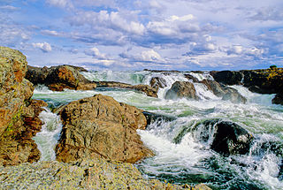
The Kazan River, is a Canadian Heritage River located in Nunavut, Canada. The Dene name for the river was Kasba-tue meaning "white partridge river." The name was apparently changed to Kazan in the late 19th century due to the influence of Order of Mary Immaculate missionaries. The river headwaters are in northern Saskatchewan at Kasba Lake, and it flows north for about 1,000 kilometres (620 mi) before emptying into Baker Lake, on the opposite side of the mouth of the Thelon River. Along its course the river flows through several lakes, including Ennadai Lake and Yathkyed Lake, over the Kazan Falls, down a red sandstone gorge and through both boreal forest and tundra. It is the last section of the river, below Ennadai Lake, that is above the timber line and is designated a Canadian Heritage River.

The barren-ground caribou is a subspecies of the reindeer that is found in the Canadian territories of Nunavut and the Northwest Territories, in northern Alaska and in south-western Greenland. It includes the Porcupine caribou of Yukon and Alaska. The barren-ground caribou is a medium-sized caribou, smaller and lighter-colored than the boreal woodland caribou, with the females weighing around 90 kg (200 lb) and the males around 150 kg (330 lb). However, on some of the smaller islands, the average weight may be less. The large migratory herds of barren-ground caribou take their names from the traditional calving grounds, such as the Ahiak herd, the Baffin Island herds, the Bathurst herd, the Beverly herd, the Bluenose East herd, the Bluenose West herd, the Porcupine herd and the Qamanirjuaq herd.

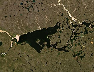
Dubawnt Lake is a lake in the Kivalliq Region, Nunavut, Canada. It is 3,630 km2 (1,400 sq mi) in size and has several islands. It is about 320 km (200 mi) north of the Four Corners, about 480 km (300 mi) west of Hudson Bay and about 400 km (250 mi) south of the Arctic Circle. To the northwest is the Thelon Wildlife Sanctuary. Its main inlet and outlet is the north-flowing Dubawnt River which joins the Thelon River at Beverly Lake. The Thelon flows east to Hudson Bay at Chesterfield Inlet. It is on the line of contact between the Sayisi Dene band of Eastern Caribou-Eater Chipewyan people and the Harvaqtuurmiut and Ihalmiut bands of Caribou Inuit. The first recorded European to reach the lake was Samuel Hearne in 1770, but it remained largely unknown to outsiders until it was explored by Joseph Tyrrell in 1893. There are no permanent settlements but there are fly-in fish camps where large lake trout can be caught during the two month ice-free season.

Kivallirmiut, also called the Caribou Inuit, barren-ground caribou hunters, are Inuit who live west of Hudson Bay in Kivalliq Region, Nunavut, between 61° and 65° N and 90° and 102° W in Northern Canada.
The Thelon Wildlife Sanctuary, at 52,000 square kilometres (20,077 sq mi), over twice the area of Belgium, is the largest wildlife refuge in Canada. It is located in northern Canada's Arctic region, north of the tree line, straddling the Northwest Territories and Nunavut, halfway between Baker Lake and Yellowknife, and bordered on the north between the Baillie River on the west and the Consul River at the east by the Back River. It is the namesake of the Thelon River, whose river valley is resplendent with boreal forest biological diversity, hence its identification as a "Biological Site of Universal Importance" by the International Biological Program (IBP) in the 1960s.
Beverly Lake is a lake in the Kivalliq Region, Nunavut, Canada. It is located north of the Arctic tree line about 150 km (93 mi) northwest of Baker Lake, Nunavut. The western half of the lake is within Thelon Wildlife Sanctuary. The Thelon River, at the confluence with the Dubawnt River, empties into the lake's southwestern bank. The Kazan River empties into the Thelon River at Beverly Lake's southeastern bank, between Beverly and Aberdeen Lakes. A delta occurs on the Beverly Lake's southern edge, which includes the Isarurjuaq Peninsula.
Qamanirjuaq Lake formerly Kaminuriak Lake, pronunciation: ka-min-YOO-ree-ak; meaning: "huge lake adjoining a river at both ends", is a lake in the Kivalliq Region, Nunavut, Canada. It is the first of several named lakes on the eastward flow of the Ferguson River through the eastern barrenlands. The lake is located about 2 km (1 mi) downstream from Ferguson Lake, and adjacent upstream to Parker Lake South. The Ferguson River passes through a series of rapids before entering the western arm of Qamanirjuaq Lake.
Edgar Vernon Christian was an English adventurer and writer who died in Northern Canada.
Northern Canadian Shield taiga is a taiga ecoregion located in northern Canada, stretching from Great Bear Lake in the Northwest Territories to Hudson Bay in eastern Nunavut. The region supports conifer forests to its northern edge, where the territory grades into tundra. The open forest in this transition zone is characterized by widely scattered, stunted stands of black spruce and tamarack, with some white spruce. The ecoregion lies over the northwestern extent of the Canadian Shield.
Caribou herds in Canada are discrete populations of seven subspecies that are represented in Canada. Caribou can be found from the High Arctic region south to the boreal forest and Rocky Mountains and from the east to the west coasts.

The reindeer is a widespread and numerous species in the northern Holarctic, being present in both tundra and taiga. Originally, the reindeer was found in Scandinavia, eastern Europe, Russia, Mongolia, and northern China north of the 50th latitude. In North America, it was found in Canada, Alaska, and the northern contiguous USA from Washington to Maine. In the 19th century, it was apparently still present in southern Idaho. It also occurred naturally on Sakhalin, Greenland, and probably even in historical times in Ireland.
The Canadian Low Arctic Tundra ecoregion covers a rolling landscape of shrubby tundra vegetation along the northern edge of the mainland Canada along the border of the Northwest Territories and Nunavut, and a small portion in Quebec on the northeast coast of Hudson Bay. The region is important for large herds of caribou and other large mammals, and for large nesting colonies of birds such as snow geese. The region is mostly intact, with 95% remaining intact.
