
Charlotte Harbor is a census-designated place (CDP) in Charlotte County, Florida, United States. The name Charlotte Harbor also refers to Charlotte Harbor (estuary) and Charlotte Harbor Preserve State Park, a 42,000-acre (17,000 ha) preserve with 70 miles (110 km) of shoreline along Charlotte Harbor in Charlotte County.
The Tamiami Trail is the southernmost 284 miles (457 km) of U.S. Highway 41 (US 41) from State Road 60 (SR 60) in Tampa to US 1 in Miami. A portion of the road also has the hidden designation of State Road 90 (SR 90).

The Seminole Gulf Railway is a short line freight and passenger excursion railroad headquartered in Fort Myers, Florida, that operates two former CSX Transportation railroad lines in Southwest Florida. The company's Fort Myers Division, which was previously the southernmost segment of CSX's Fort Myers Subdivision, runs from Arcadia south to North Naples via Punta Gorda, Fort Myers, Estero, and Bonita Springs. The company's other line, the Sarasota Division, runs from Oneco south through Sarasota. Seminole Gulf acquired the lines in November 1987 and operates its own equipment. The company's first train departed Fort Myers on November 14, 1987.

Southwest Florida is the region along the southwest Gulf coast of the U.S. state of Florida. The area is known for its beaches, subtropical landscape, and winter resort economy.

State Road 29 is a state highway that runs north–south through Southwest Florida. It begins in Carnestown and runs north to a point just south of Palmdale. A rural road, it runs mostly through uninhabited farmland in its northern half, and along wetlands in its southern half. The route previously continued south of Carnestown to Everglades City and Chokoloskee, which has since become County Road 29.
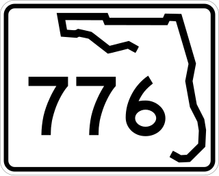
State Road 776 (SR 776) is a 25-mile-long (40 km) state highway serving southern Sarasota County and northwestern Charlotte County, Florida. It acts as a loop road of U.S. Route 41 (US 41) that bypasses North Port.

Charlotte Harbor Preserve State Park is a 46,000-acre (190 km2) Florida State Park, composed of islands and land that surrounds Charlotte Harbor. It is part of the Southwest Florida Water Management District and protects the Gasparilla Sound/ Charlotte Harbor, Cape Haze, Matlacha Pass, and Pine Island Sound aquatic preserves. It is site 22 on southern section of the Great Florida Birding Trail and offers boating, paddling, fishing, and hiking.

The Punta Gorda Atlantic Coast Line Depot is a historic Atlantic Coast Line Railroad depot in Punta Gorda, Florida, United States. It is located at 1009 Taylor Road.

Interstate 75 (I-75) is a part of the Interstate Highway System that runs from the Hialeah–Miami Lakes border, a few miles northwest of Miami, to Sault Ste. Marie in the Upper Peninsula of Michigan. I-75 begins its national northward journey near Miami, running along the western parts of the Miami metropolitan area before traveling westward across Alligator Alley, resuming its northward direction in Naples, running along Florida's Gulf Coast, and passing the cities of Fort Myers, Punta Gorda, Venice, and Sarasota. The freeway passes through the Tampa Bay area before turning inward toward Ocala, Gainesville, and Lake City before leaving the state and entering Georgia. I-75 runs for 471 miles (758 km) in Florida, making it the longest Interstate in the state and also the longest in any state east of the Mississippi River. The Interstate's speed limit is 70 mph (110 km/h) for its entire length in Florida.

U.S. Highway 17 (US 17) in Florida is a north–south United States Numbered Highway that runs 317 miles (510 km) from the Punta Gorda, Florida Metropolitan Statistical Area northeast to the Jacksonville metropolitan area.
The Edison Bridge is a set of two one-way bridges located in Fort Myers, Florida. Named after inventor Thomas Alva Edison, the two bridges carry each direction of U.S. Highway 41 Business over the Caloosahatchee River, connecting downtown Fort Myers with North Fort Myers.
The Florida Southern Railway was a railway that operated in Florida in the late 1800s. It was one of Florida's three notable narrow gauge railways when it was built along with the South Florida Railway and the Orange Belt Railway. The Florida Southern was originally chartered to run from Lake City south through central Florida to Charlotte Harbor. However, with the influence of Henry B. Plant, it operated with two discontinuous segments that would be part of the Plant System, which would later become part of the Atlantic Coast Line Railway.
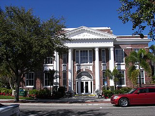
Punta Gorda, a city located in Southwest Florida, is the county seat of Charlotte County, Florida, United States. As of the 2020 U.S. Census, the city had a population of 19,471, up from 16,641 at the 2010 census. Punta Gorda is the principal city of the Punta Gorda Metropolitan Statistical Area, part of the North Port-Bradenton Florida Combined Statistical Area.
The Charlotte Harbor and Northern Railway is a historic railroad line that at its greatest extent serviced Gasparilla Island in Charlotte Harbor and a major shipping port that once operated there. The railroad's principal purpose was to transport phosphate mined along the Peace River and in the Bone Valley region of Central Florida to the port to be shipped. It also brought passengers to the island community of Boca Grande on Gasparilla Island, and is largely responsible for making Boca Grande the popular tourist destination it is today. Part of the line remains in service today between Mulberry and Arcadia, which is now owned and operated by CSX Transportation. Today, it makes up CSX's Achan Subdivision and part of their Brewster Subdivision.

The Albert W. Gilchrist Bridge is a bridge in Charlotte County, Florida, crossing the Peace River between Port Charlotte, Florida, and Punta Gorda, Florida. The two-lane 45-foot-tall structure carries the southbound lanes of U.S. Route 41. US 41's northbound lanes are carried over the river on the adjacent Barron Collier Bridge. It was named for former Florida Governor Albert W. Gilchrist, who resided in Punta Gorda.
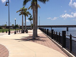
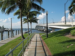
Harborwalk is a 2.4-mile (3.9 km) multi-use recreational trail located in Punta Gorda which runs along the Charlotte Harbor and the Peace River.
Fishermen's Village is a waterfront shopping, entertainment, and resort complex located along Charlotte Harbor in Punta Gorda, Florida. It includes over 30 shops and restaurants and The Suites accommodations located on the second floor. It also includes a full service marina. Live music and other forms of entertainment are also common at Fishermen's Village
The Atlantic Coast Line Railroad's Lakeland—Fort Myers Line was one of the railroad company's secondary main lines in Central and Southwest Florida. It was built incrementally in the late 1800s and early 1900s. Parts of the line are still active today.

The Green Bridge is a bridge carrying U.S. Highway 41 Business over the Manatee River between Palmetto and Bradenton, Florida. Built in 1986, the current Green Bridge is 40 feet (12 m) tall and carries four lanes. The original Green Bridge, which partially still stands as a fishing pier, was built in 1927 and named for Emmet P. Green, a local resident who served on the state road board.


