
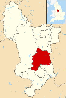
Chesterfield is a large market town and borough in Derbyshire, England, 24 miles (39 km) north of Derby and 11 miles (18 km) south of Sheffield at the confluence of the River Rother and River Hipper. Including Whittington, Brimington and Staveley, it had a population of 103,801 in 2012, making it Derbyshire's second largest town. It has been traced to a transitory Roman fort of the 1st century AD. The name of the later Anglo-Saxon village comes from the Old English ceaster and feld (pasture). It has a sizeable street market three days a week. The town sits on a coalfield, but little visual evidence of mining remains. Its main landmark is the crooked spire of the Church of St Mary and All Saints.
Amber Valley is a local government district and borough in the east of Derbyshire, England. It takes its name from the River Amber. It covers a semi-rural zone with four main towns whose economy was based on coal mining and remains to some extent influenced by engineering, distribution and manufacturing, holding for instance the headquarters and production site of Thorntons confectionery.

Derbyshire Dales is a local government district in Derbyshire, England. The population at the 2011 Census was 71,116. Much of it is in the Peak District, although most of its population lies along the River Derwent.
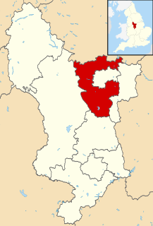
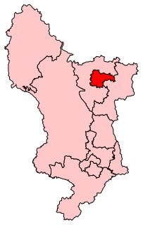
North East Derbyshire is a local government district in Derbyshire, England. It borders the districts of Chesterfield, Bolsover, Amber Valley and Derbyshire Dales in Derbyshire, and Sheffield and Rotherham in South Yorkshire. The population of the district as taken at the 2011 Census was 99,023. The district council is a non-constituent partner member of the Sheffield City Region Combined Authority.

Broxtowe is a local government district with borough status in Nottinghamshire, England, west of the City of Nottingham. The population of the district as taken at the 2011 Census was 109,487. It is part of the Nottingham Urban Area. Broxtowe's neighbour to the west is the borough of Erewash, which is in Derbyshire.

The City of Wakefield is a local government district in West Yorkshire, England, with the status of a city and metropolitan borough. Wakefield is the district's administrative centre. The population of the City of Wakefield at the 2011 Census was 325,837. The district includes the ‘Five Towns’ of Normanton, Pontefract, Featherstone, Castleford and Knottingley. Other towns include Ossett, Horbury, Hemsworth, South Kirkby and Moorthorpe and South Elmsall. The City and borough are governed by Wakefield Metropolitan District Council. Wakefield is located between Leeds and Barnsley

Wales is a village and a civil parish in the Metropolitan Borough of Rotherham in South Yorkshire, England. Historically part of the West Riding of Yorkshire it borders, to the south, Derbyshire and is astride the M1 motorway. The civil parish of Wales, which has a population of 6,455, increasing to 7,069 at the 2011 Census, encompasses the village and neighbouring settlement Kiveton Park.

Gleadless Valley ward—which includes the districts of Gleadless Valley, Heeley, Lowfield, and Meersbrook—is one of the 28 electoral wards in City of Sheffield, England. It is located in the southern part of the city and covers an area of 4.5 km2. The population of this ward in 2011 was 21,089 people in 9,516 households. It is one of the five wards that form the Sheffield Heeley parliamentary constituency whose Member of Parliament elected at the 2001 general election was Meg Munn. Gleadless Valley actually describes the valley that separates Hemsworth from Herdings, and is a broad area that covers several housing estates: Hemsworth, Herdings and Rollestone. Gleadless Valley is bordered by Gleadless and Norton.
Dore and Totley ward—which includes the districts of Bradway , Dore, Totley, and Whirlow—is one of the 28 electoral wards in City of Sheffield, England. It is currently represented by three Liberal Democrat councillors. It is located in the southwestern part of the city and covers an area of 26.3 km2. The population of this ward in 2001 was 16,404 people in 7,037 households. Dore and Totley ward is one of the five wards that make up the Sheffield Hallam Parliamentary constituency. The population of Dore and Totley is 16,740 (2011) with 7,334 Households.

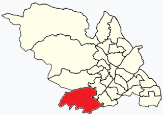
Graves Park ward—which includes the districts of Norton, Norton Lees, Norton Woodseats, and Woodseats—is one of the 28 electoral wards in City of Sheffield, England. It is located in the southern part of the city and covers an area of 5.8 km2. The population of this ward in 2011 was 16,705 people in 7,464 households. It is one of the five wards that form the Sheffield Heeley parliamentary constituency whose Member of Parliament elected at the 2001 general election was Meg Munn. The districts of this ward were in the historic county of Derbyshire, but they have now been absorbed into the metropolitan borough of Sheffield, thus placing them in the ceremonial county of South Yorkshire.
Amber Valley is a constituency in Derbyshire, represented in the House of Commons of the UK Parliament since 2010 by Nigel Mills, a Conservative.
Chesterfield is a constituency represented in the House of Commons of the UK Parliament since 2010 by Toby Perkins of the Labour Party.

North East Derbyshire is a constituency created in 1885 represented in the House of Commons of the UK Parliament since 2017 by Lee Rowley of the Conservative Party. This was the first time a Conservative candidate had been elected since 1935.
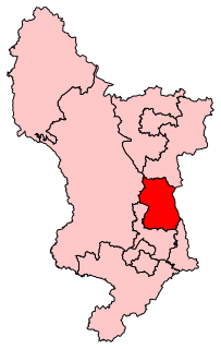
Calow is a small village and civil parish in the county of Derbyshire in England. The population of the village at the 2011 United Kingdom Census was 2,494. Calow is in the North East Derbyshire local government district of Derbyshire and is located immediately adjacent to the larger market town of Chesterfield.

Brampton is an area in the west of Chesterfield, Derbyshire. Originally a village separate from the town, it became absorbed into it over time due to urban sprawl. It is centred on Chatsworth Road, the main arterial road (A619) that connects the town with the Peak District and Manchester.

Creswell railway station serves the village Creswell in Derbyshire, England. The station is on the Robin Hood Line between Nottingham and Worksop. It is also the nearest station to the larger village of Clowne.

Brimington is a civil parish within the borough of Chesterfield in north-east Derbyshire, England. The population of the civil parish including Hollingwood taken at the 2011 census was 8,788. The town of Staveley is to the east, and Hollingwood is nearby. The parish includes Brimington Common along the Calow Road, and New Brimington, a late 19th-century extension towards the Staveley Iron Works.
Old Whittington is a village in Derbyshire and 2 miles (3.2 km) north of Chesterfield and is 10 miles (16 km) south-east of Sheffield. The population of the ward at the 2011 Census was 4,181. The village lies on the River Rother.
Whittington railway station is a former railway station on the southern edge of New Whittington, Derbyshire, England.