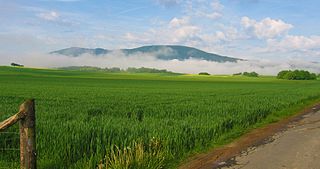
The Westerwald is a low mountain range on the right bank of the river Rhine in the German federal states of Rhineland-Palatinate, Hesse and North Rhine-Westphalia. It is a part of the Rhenish Massif. Its highest elevation, at 657 m above sea level, is the Fuchskaute in the High Westerwald.
Lahn-Dill is a Kreis (district) in the west of Hesse, Germany. Neighboring districts are Siegen-Wittgenstein, Marburg-Biedenkopf, Gießen, Wetteraukreis, Hochtaunuskreis, Limburg-Weilburg, Westerwaldkreis.
Limburg-Weilburg is a Kreis (district) in the west of Hesse, Germany. Neighboring districts are Lahn-Dill, Hochtaunuskreis, Rheingau-Taunus, Rhein-Lahn, Westerwaldkreis.
The Westerwaldkreis is a district (Kreis) in the north-east of Rhineland-Palatinate, Germany. Neighbouring districts are Altenkirchen, Lahn-Dill, Limburg-Weilburg, Rhein-Lahn, the district-free city Koblenz, Mayen-Koblenz and Neuwied.
The Hoher Meißner is a mountain massif with a height of 753.6 m and is located in the Meißner-Kaufunger Wald nature park in Hesse, Germany.

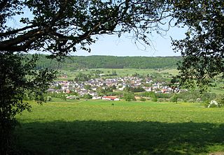
Dornburg is a municipality in the Westerwald in Limburg-Weilburg district in Hesse, Germany.

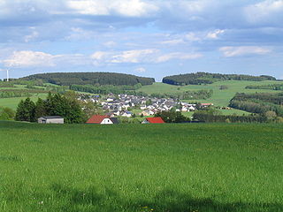
Stein-Neukirch is an Ortsgemeinde – a community belonging to a Verbandsgemeinde – in the Westerwaldkreis in Rhineland-Palatinate, Germany.
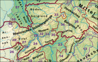
The Rhenish Massif, Rhine Massif or Rhenish Uplands is a geologic massif in western Germany, eastern Belgium, Luxembourg and northeastern France. It is drained centrally, south to north by the river Rhine and a few of its tributaries.

The Hohe Acht is the highest mountain in the Eifel mountains of Germany. It is located on the boundary between the districts of Ahrweiler and Mayen-Koblenz in Rhineland-Palatinate.
The Wollenberg is a hill in Hesse, Germany.

Völzberger Köpfchen is a hill in the Vogelsberg mountain range, located in Hesse, Germany. It rises 570.8 m making it the highest point in the Main-Kinzig district.
The Fuchskaute is an extinct volcano and, at 657.3 m above sea level (NHN), the highest mountain of the Westerwald and the county of Westerwaldkreis in the German state of Rhineland-Palatinate.

The Nassau Nature Park is a 561.71 km2 nature park in the southwestern Westerwald and northwestern Taunus in Rhineland-Palatinate. It was designated in November 1963 and expanded in 1979.
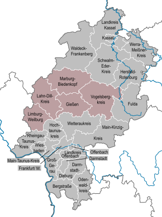
The region of Middle Hesse is one of three planning regions in the German state of Hesse, alongside North and South Hesse. Its territory is identical with that of the administrative province of Gießen and covers the counties of Limburg-Weilburg, Lahn-Dill-Kreis, Gießen, Marburg-Biedenkopf and Vogelsbergkreis. The Middle Hesse Regional Assembly, which decides on the regional plan, currently consists of 31 members chosen by the five counties and the three towns with special status: Gießen, Marburg and Wetzlar. The regional assembly has tasked the governing president (Regierungspräsident) with delivering regional management. The Mid-Hesse Regional Management Association was founded on 22 January 2003.
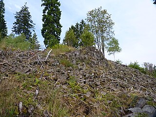
The Kranstein is a rock formation which is designated as a natural monument in the German mountain range of Westerwald. It is situated by the district road, Kreisstraße 95, between Willmenrod and Weltersburg. It is registered as number "ND-7143-507" in the list of natural monuments of the state of Rhineland-Palatinate and is a geotope in the Westerwald-Lahn-Taunus Geopark.
As well as being a low mountain range, the Westerwald is also a natural region in the system of natural regional division of Germany. Within that it is a major unit group with the number "32". According to this system the major unit group of the Westerwald belongs to the basement plate (Grundgebirgsschollenland), which describes the type of mountain-building process by which it was formed. The major unit group extends across the states of Hesse, North Rhine-Westphalia and Rhineland-Palatinate. It is roughly bounded by the valleys of the Lahn, Rhine and Sieg, whereby the hills immediately south of the Heller and Sieg are not considered to be part of it.
The Trödelsteine, also called the Trödelstein, is a rock formation near Emmerzhausen in the county of Altenkirchen in the German state of Rhineland-Palatinate. It consists of columnar basalt and a basaltic blockfield in the Heller Upland. The rock formation has been designated as a natural monument, about 0.3 hectares in area.

The Bacher Lay is a nature reserve in Germany, which covers an area of 44.7 hectares in the county of Westerwaldkreis in the German state of Rhineland-Palatinate. It is a geotope of the Westerwald-Lahn-Taunus Geopark

The Westerwald-Lahn-Taunus National Geopark is a community initiative by the counties of Altenkirchen, Lahn-Dill, Limburg-Weilburg, Westerwald and Marburg-Biedenkopf. The geopark, which covers an area of 3,846 km², lies within parts of the German states of Hesse and Rhineland-Palatinate and within the natural region of the German Central Uplands.

