
The bongo is a herbivorous, mostly nocturnal forest ungulate.

The demography of Kenya is monitored by the Kenyan National Bureau of Statistics. Kenya is a multi-ethnic state in the Great Lakes region of East Africa. It is inhabited primarily by Bantu and Nilotic populations, with some Cushitic-speaking ethnic minorities in the north. Its total population was at 47,564,296 as of the 2019 census.

The Maasai are a Nilotic ethnic group inhabiting northern, central and southern Kenya and northern Tanzania. They are among the best known local populations internationally due to their residence near the many game parks of the African Great Lakes, and their distinctive customs and dress. The Maasai speak the Maa language, a member of the Nilotic language family that is related to the Dinka, Kalenjin and Nuer languages. Except for some elders living in rural areas, most Maasai people speak the official languages of Kenya and Tanzania, Swahili and English. The Maasai population has been reported as numbering 1,189,522 in Kenya in the 2019 census, compared to 377,089 in the 1989 census.
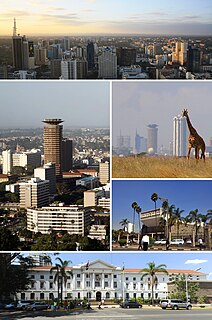
Nairobi is the capital and the largest city of Kenya. The name comes from the Maasai phrase Enkare Nairobi, which translates to "cool water", a reference to the Nairobi River which flows through the city. The city proper had a population of 4,397,073 in the 2019 census, while the metropolitan area has a population of 9,354,580. The city is popularly referred to as the Green City in the Sun.

Rift Valley Province of Kenya, bordering Uganda, was one of Kenya's eight provinces, before the Kenyan general election, 2013. Rift Valley Province was the largest and one of the most economically important provinces in Kenya. It was dominated by the Kenya Rift Valley which passes through it and gives the province its name. According to the 2009 Census, the former province covered an area of 182,505.1 square kilometres and would have had a population of 10,006,805, making it the largest and most populous province in the country. The bulk of the provincial population inhabited a strip between former Nairobi and Nyanza Province. The capital was the town of Nakuru.

Kenya, officially the Republic of Kenya, is a country in Eastern Africa. At 580,367 square kilometres (224,081 sq mi), Kenya is the world's 48th largest country by total area. With a population of more than 47.6 million people in the 2019 census, Kenya is the 29th most populous country. Kenya's capital and largest city is Nairobi, while its oldest city and first capital is the coastal city of Mombasa. Kisumu City is the third-largest city and also an inland port on Lake Victoria. Other important urban centres include Nakuru and Eldoret. As of 2020, Kenya is the third-largest economy in sub-Saharan Africa after Nigeria and South Africa. Kenya is bordered by South Sudan to the northwest, Ethiopia to the north, Somalia to the east, Uganda to the west, Tanzania to the south, and the Indian Ocean to the southeast.
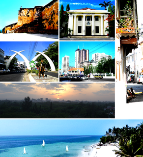
Mombasa is a coastal city in southeast Kenya along the Indian Ocean. The city is known as the white and blue city in Kenya. It is the country's oldest and second-largest city, with a population of about 1,208,333 people according to the 2019 census. Its metropolitan region is the second-largest in the country, and has a population of 3,528,940 people.
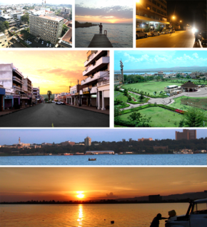
Kisumu is the third-largest city in Kenya after the capital, Nairobi, and the coastal city of Mombasa. It is the third-largest city in the Lake Victoria Basin. Kisumu is not far from Kogelo, a village known for being the hometown of Barack Obama Sr., the father to the 44th president of the United States. Culturally, Kisumu serves as the headquarters of the Luo speaking people of East Africa. It was the most prominent urban centre in the pre-colonial, post-colonial, and modern era for natives of Kavirondo region. Some of the most significant political events that have shaped the trajectory Kenya have happened in Kisumu including the famous political spat between founding president of Kenya Jomo Kenyatta and founding vice president Jaramogi Odinga during the opening of Jaramogi Oginga Odinga Teaching and Referral Hospital in 1969. Apart from being an important political city, it is one of the premier industrial and commercial centres in Kenya. The city is currently undergoing an urban rejuvenation of the downtown and lower town which includes modernizing the lake front, decongesting main streets, and making the streets pedestrian-friendly. While a naturally beautiful city, Kisumu has suffered from political neglect of the central government in Nairobi and poor leadership by the local political elites.

Nakuru is the fourth-largest urban centre proper in Kenya after Nairobi, Mombasa, and Kisumu in that order. However, Nakuru's metro urban area is the third largest in Kenya after Nairobi and Mombasa. It is the capital of Nakuru County and former capital of the Rift Valley Province as well as home to Flamingo Radio which is the largest neo-urban Radio in the metropolis. Its urban and rural population is 570,674 inhabitants according to the 2019 census. It is the largest urban centre in the Rift Valley with Eldoret in Uasin Gishu following closely behind. Nakuru lies about 1,850 m above sea level. Alternative names include Nax or Naxar, and Kurusalem.
Kenya is a multilingual country. The Bantu Swahili language and English, the latter being inherited from colonial rule, are widely spoken as lingua franca. They serve as the two official working languages. Including second-language speakers, there are more speakers of Swahili than English in Kenya.

Lamu County is located in the Northern Coast of Kenya and is one of the Six Coastal Counties in Kenya. It borders Tana River County in the southwest, Garissa County to the north, Republic of Somalia to the northeast and the Indian Ocean to the South. It lies 1° 40’ and 2° 30’ south and longitude 40° 15’ and 40° 38’ east. The county has a land surface of 6,273.1 km that include the mainland and over 65 islands that form the Lamu Archipelago. The total length of the coastline is 130 km while land water mass area stands at 308 km.

Mombasa County is one of the 47 counties of Kenya. It's the capital and the only city in the county of Mombasa. Initially it was one of the former districts of Kenya but in 2013 it was reconstituted as a county, on the same boundaries. It is the smallest county in Kenya, covering an area of 229.7 km2 excluding 65 km2 of water mass. The county is situated in the south eastern part of the former Coast Province. It borders Kilifi County to the north, Kwale County to the south west and the Indian Ocean to the east. Administratively, the county is divided into seven divisions, eighteen locations and thirty sub-locations.

Tana River County is a county in the former Coast Province, Kenya. It is named after the Tana River. It has an area of 38,437 square kilometres (14,841 sq mi) and a population of 315,943. The capital and largest town is Hola.
Kilifi County is a county of Kenya. It was formed in 2010 as a result of a merger of Kilifi District and Malindi District. Its capital is Kilifi and its largest town is Malindi. The county has a population of 1,453,787. It covers an area of 12,245.90 km2 (4,728.17 sq mi).
Taita–Taveta County is a county of Kenya. It lies approximately 140 km northwest of Mombasa and 380 km southeast of Nairobi. The County headquarters are located in Mwatate, which is central to the county.
Vihiga County is an administrative region in the former Western Province of Kenya whose headquarters are in Mbale, the largest town in the county. The county has a population of 554,622 and an area of 563 km2. Vihiga County was split from Kakamega County in 1990. In 2019's census, Vihiga was found to have a population of 590, 013, an increase of 35, 391 from the 2009's count.

Mandera County is a county in Kenya. Its capital and largest town is Mandera. The county is bordered by Ethiopia to the north, to the east and by Wajir County to the southwest. According to the 2019 census, the county has a population of 1,200,89,milion and an area of 25,939.8 km2. The main economic activity in the county is pastoralism, while others include cross-border trade with Ethiopia, artisanal mining, beekeeping and agriculture along the Dawa River.

Wajir County is a county in the former North Eastern Province of Kenya. Its capital and largest town is Wajir. The county has a population of 720,000 and an area of 55,840.6 km2. The county is bordered to the north by Ethiopia, to the northeast by Mandera County, to the east by Somalia, to the south by Garissa County, to the west by Isiolo County and to the northwest by Marsabit County. The county has six constituencies: eldas, Tarbaj, Wajir North, Wajir West, Wajir East, and Wajir South.

The predominant religion in Kenya is Christianity, which is adhered to by an estimated 85.52% of the total population. Islam is the second largest religion in Kenya, practiced by 10.91 percent of Kenyans. Other faiths practiced in Kenya are Baháʼí, Buddhism, Hinduism and traditional religions.

The Colony and Protectorate of Kenya, commonly known as British Kenya, was part of the British Empire in Africa. It was established when the former East Africa Protectorate was transformed into a British Crown colony in 1920. Technically, the 'Colony of Kenya' referred to the interior lands, while a 16 km (10 mi) coastal strip was the 'Protectorate of Kenya', but the two were controlled as a single administrative unit. The colony came to an end in 1963 when a black majority government was elected for the first time and eventually declared independence as Kenya.
