A cable-stayed bridge has one or more towers, from which cables support the bridge deck. A distinctive feature are the cables or stays, which run directly from the tower to the deck, normally forming a fan-like pattern or a series of parallel lines. This is in contrast to the modern suspension bridge, where the cables supporting the deck are suspended vertically from the main cable, anchored at both ends of the bridge and running between the towers. The cable-stayed bridge is optimal for spans longer than cantilever bridges and shorter than suspension bridges. This is the range within which cantilever bridges would rapidly grow heavier, and suspension bridge cabling would be more costly.

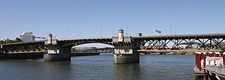
The Burnside Bridge is a 1926-built bascule bridge that spans the Willamette River in Portland, Oregon, United States, carrying Burnside Street. It is the second bridge at the same site to carry that name. It was added to the National Register of Historic Places in November 2012.

The Oregon City Bridge, also known as the Arch Bridge, is a steel through arch bridge spanning the Willamette River between Oregon City and West Linn, Oregon, United States. Completed in 1922, it is listed on the National Register of Historic Places. It was built and is owned by the Oregon Department of Transportation (ODOT) as part of Oregon Route 43 and is the third-southernmost Willamette bridge in the Portland metropolitan area, after the Boone Bridge in Wilsonville and the Oregon 219 bridge near Newberg.

The Waco Suspension Bridge crosses the Brazos River in Waco, Texas. It is a single-span suspension bridge, with a main span of 475 ft. Opened on November 20, 1869, it contains nearly 3 million bricks. It is located north of downtown Waco, connecting Indian Spring Park with Doris D. Miller Park. Every year on Independence Day, the bridge serves as a place where thousands of locals gather to watch fireworks. Indian Spring Park marks the location of the origin of the town of Waco, where the Huaco Indians had settled on the bank of the river, at the location of a cold spring.

The Rainbow Bridge and Veterans Memorial Bridge are two bridges that cross the Neches River in Southeast Texas just upstream from Sabine Lake. It allows State Highway 87 and State Highway 73 to connect Port Arthur in Jefferson County on the southwest bank of the river. Bridge City in Orange County is on the northeast bank.

The Waldo–Hancock Bridge was the first long-span suspension bridge erected in Maine, as well as the first permanent bridge across the Penobscot River downstream from Bangor. The name comes from connecting Waldo and Hancock counties. The bridge was built in 1931 and retired in 2006, when the new Penobscot Narrows Bridge was opened just a few yards away. Demolition of the structure was completed by 2013.

An extradosed bridge employs a structure that combines the main elements of both a prestressed box girder bridge and a cable-stayed bridge. The name comes from the word extrados, the exterior or upper curve of an arch, and refers to how the "stay cables" on an extradosed bridge are not considered as such in the design, but are instead treated as external prestressing tendons deviating upward from the deck. In this concept, they remain part of the main bridge superstructure.

The George and Cynthia Mitchell Memorial Causeway is a set of causeways in Galveston, Texas, United States. Two of the routes carry the southbound and northbound traffic of Interstate 45, while the original causeway is restricted to rail traffic. It is the main roadway access point to Galveston Island. The second access point is Bolivar Ferry.

Bartlett's Bridge is a historic stone arch bridge carrying Clara Barton Road over the French River in Oxford, Massachusetts. Built in 1889, it is a rare example of late 19th-century stone bridge construction in the state. It was originally built to provide improved capacity for vehicles servicing a nearby textile mill complex. The bridge was listed on the National Register of Historic Places in 2000.

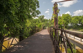
The Bluff Dale Bridge is a historic cable-stayed bridge located near Bluff Dale, Texas, United States. Built in 1891, the bridge spans 225 feet (69 m) across the Paluxy River. The road deck is 28 feet (8.5 m) above the river and held in place by fourteen 1-inch-diameter (2.5 cm) cables attached to the towers made of 9-inch-diameter (23 cm) iron pipe.

The John O'Connell Bridge is a cable-stayed bridge over the Sitka Channel located in Sitka, Alaska. The bridge connects the town of Sitka on Baranof Island to the airport and Coast Guard Station on Japonski Island. Until the bridge was completed in 1971, the commute was only achievable through a ferry service. The bridge is named after John W. O'Connell, a former mayor of Sitka. The two-lane bridge is 1,255 feet (383 m) in total length, with a main span of 450 feet (140 m). The bridge was also the United States' first vehicular cable-stayed girder spanned bridge. The four 100-foot-high (30 m) steel pylons carry two three-cable sets, each carrying a section of the bridge deck. Special consideration was given to the bridge's aesthetics due to its proximity to nearby Castle Hill.

The Black Suspension Bridge spans the Colorado River in the inner canyon of Grand Canyon National Park. The span length is 440 feet (130 m). The bridge is part of the South Kaibab Trail and is the river crossing used by mules going to Phantom Ranch. The Black Bridge and Silver Bridge, located about 700 metres (2,300 ft) downstream, are the only spans in hundreds of river miles.

The McKee Street Bridge carries McKee Street across Buffalo Bayou in Houston, Texas. Built in 1932, the three-span reinforced concrete girder bridge connects the Second and Fifth Ward areas, northeast of downtown Houston. The bridge was listed on the National Register of Historic Places on September 3, 2002.

The General Norzagaray Bridge is a brick and masonry barrel vault bridge built in 1855 in San Juan, Puerto Rico. Also known as Puente de los Frailes, it brings what is now Puerto Rico Highway 873 across Frailes Creek, a tributary to the Guaynabo River. It has eight 9.8-metre (32 ft) barrel vault spans. Its total length is 120.7 metres (396 ft) and its roadway width is 7.00 metres (22.97 ft). It was listed on the National Register of Historic Places (NRHP) in 1995, and on the Puerto Rico Register of Historic Sites and Zones in 2000.
The Harbor Bridge Project is the replacement of the existing through arch bridge that crosses the Corpus Christi Ship Channel, which serves the Port of Corpus Christi in Corpus Christi, Texas, with a modern cable-stayed bridge design. The route will connect with SH 286 at its southern terminus and US 181 on the north. Groundbreaking on construction took place on August 8, 2016 and was scheduled to be completed by the spring of 2020, but was extensively delayed by engineering and design issues, and is tentatively planned to be completed in 2025.

The West Sixth Street Bridge is a historic stone arch bridge in downtown Austin, Texas. Built in 1887, the bridge is one of the state's oldest masonry arch bridges. It is located at the site of the first bridge in Austin, carrying Sixth Street across Shoal Creek to link the western and central parts of the old city. The bridge was added to the National Register of Historic Places in 2014.

The Houston Street Viaduct is a viaduct in Dallas, Texas, that carries Houston Street across the Trinity River, connecting Downtown Dallas and Oak Cliff. Designed by Ira G. Hedrick, it was built in 1911, and is listed on the National Register of Historic Places.

The East Navidad River Bridge, also known as the State Highway 3 Bridge at East Navidad River, is a historic concrete bridge that carries FM 1579 across the East Navidad River about 3.4 miles (5.5 km) east of Schulenberg in Fayette County, Texas. The 199-foot-long (61 m) cantilever bridge has a 70-foot (21 m) center span. Concrete piers and abutments support the two cantilever arms. The total width of the bridge is 21.17 feet (6.45 m), providing an 18-foot-wide (5.5 m) roadway. The bridge gives the appearance of an arch but is in fact two cantilevered arms joined in the center of the main span and anchored and countered at the ends. Concrete piers with skewed abutments provide support.


