A chine is a steep-sided coastal gorge where a river flows to the sea through, typically, soft eroding cliffs of sandstone or clays. The word is still in use in central Southern England—notably in East Devon, Dorset, Hampshire and the Isle of Wight—to describe such topographical features. The term 'bunny' is sometimes used to describe a chine in Hampshire. The term chine is also used in some Vancouver suburbs in Canada to describe similar features.
The London Clay Formation is a marine geological formation of Ypresian age which crops out in the southeast of England. The London Clay is well known for its fossil content. The fossils from the lower Eocene rocks indicate a moderately warm climate, the tropical or subtropical flora. Though sea levels changed during the deposition of the clay, the habitat was generally a lush forest – perhaps like in Indonesia or East Africa today – bordering a warm, shallow ocean.

Dorset is a county in South West England on the English Channel coast. Covering an area of 2,653 square kilometres (1,024 sq mi); it borders Devon to the west, Somerset to the north-west, Wiltshire to the north-east, and Hampshire to the east. The great variation in its landscape owes much to the underlying geology which includes an almost unbroken sequence of rocks from 200 Ma to 40 Ma and superficial deposits from 2 Ma to the present. In general the oldest rocks appear in the far west of the county, with the most recent (Eocene) in the far east. Jurassic rocks also underlie the Blackmore Vale and comprise much of the coastal cliff in the west and south of the county; and although younger Cretaceous rocks crown some of the highpoints in the west, they are mainly to be found in the centre and east of the county.

Michelmersh is a small, scattered village in Hampshire, England some three miles (4.8 km) north of Romsey.

The Lambeth Group is a stratigraphic group, a set of geological rock strata in the London and Hampshire Basins of southern England. It comprises a complex of vertically and laterally varying gravels, sands, silts and clays deposited between 56-55 million years before present during the Ypresian age. It is found throughout the London Basin with a thickness between 10m and 30m and the Hampshire Basin with a thickness between 50m and less than 25m. Although this sequence only crops out on the edges of these basins, the fact that the Lambeth Group underlies some 25% of London at a depth of less than 30m means the formation is of engineering interest for tunnelling and foundations.
In geology, the Bagshot Beds are a series of sands and clays of shallow-water origin, some being fresh-water, some marine. They belong to the upper Eocene formation of the London and Hampshire basins, in England and derive their name from Bagshot Heath in Surrey. They are also well developed in Hampshire, Berkshire and the Isle of Wight. The following divisions are generally accepted:

Colwell Bay is a bay in the west of the Isle of Wight. It is located between the towns of Totland and Yarmouth. The bay's northernmost point is Cliff's End the closest point of the Island to the British mainland, with Hurst Castle lying at the end of a long peninsula just 1500 metres to the northwest. The southernmost point is Warden Point.
Ampfield is a village and civil parish in the Borough of Test Valley in Hampshire, England, between Romsey, Eastleigh, and Winchester. It had a population at the 2001 census of 1,474, increasing to 1,583 at the 2011 Census.
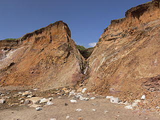
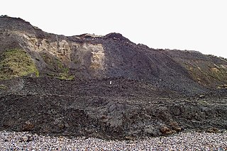
Barton Beds is the name given to a series of grey and brown clays, with layers of sand, of Upper Eocene age, which are found in the Hampshire Basin of southern England. They are particularly well exposed in the cliffs at Barton-on-Sea, which is the world type locality for the Barton Beds, and lends its name to the Bartonian age of the Eocene epoch. The clay is abundant in fossils, especially molluscs.

The Bracklesham Group, in geology, is a series of clays and marls, with sandy and lignitic beds, in the middle Eocene of the Hampshire Basin and London Basin of England.

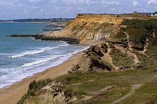
Barton on Sea is a cliff-top village in Hampshire, England with close connections physical, governmental and commercial to New Milton town, its civil parish to the north. As a settlement, Barton has a history dating back to Anglo-Saxon times. Its housing, few shops and numerous hospitality venues were largely built in the 20th century. It is effectively a suburb of New Milton. Barton is notable for the many fossils to be found in the Barton geological beds in the cliffs, as well as for the significant sea defences built to defend the cliffs against coastal erosion.

Braishfield is a village and civil parish north of Romsey in Hampshire, England. The name is thought to be derived from the Old English bræsc + feld, meaning 'open land with small branches or brushwood'. The hamlet of Pucknall lies due east of the village.

The London Basin is an elongated, roughly triangular sedimentary basin approximately 250 kilometres (160 mi) long which underlies London and a large area of south east England, south eastern East Anglia and the adjacent North Sea. The basin formed as a result of compressional tectonics related to the Alpine orogeny during the Palaeogene period and was mainly active between 40 and 60 million years ago.

Barbara Rawdon-Hastings, 20th Baroness Grey de Ruthyn, Marchioness of Hastings was a fossil collector and geological author.
Ernest St. John Burton F.R.S.A, F.L.S, F.G.S, F.Z.S, was a talented artist, composer, musician, author, and geologist.
The Bouldnor Formation is a geological formation in the Hampshire Basin of southern England. It is the youngest formation of the Solent Group and was deposited during the uppermost Eocene and lower Oligocene.

The Solent Group is a geological group in the Hampshire Basin of southern England. It preserves fossils ranging in age from Priabonian to Rupelian. The group is subdivided into three formations, the Headon Hill Formation, the Bembridge Limestone Formation and the Bouldnor Formation.
This article describes the geology of the New Forest, a national park in Hampshire, in southern England.


