Barwałd Średni

Last updated
Barwałd Średni
Village
Barwald Sredni-obelisk katastrofy.jpg
Obelisk commemorating the 1944 railway catastrophe
Poland adm location map.svg
Red pog.svg
Barwałd Średni
Coordinates: 49°52′N19°36′E / 49.867°N 19.600°E / 49.867; 19.600
Country Flag of Poland.svg  Poland
Voivodeship Lesser Poland
County Wadowice
Gmina Kalwaria Zebrzydowska

Barwałd Średni (pronounced  [ˈbarvawt ˈɕrɛdɲi] ) is a village in southern Poland, located in the administrative district of Gmina Kalwaria Zebrzydowska within Wadowice County, Lesser Poland Voivodeship. It lies approximately 6 kilometres (4 mi) west of Kalwaria Zebrzydowska, 8 km (5 mi) east of Wadowice, and 33 km (21 mi) south-west of the regional capital Kraków.

Village Small clustered human settlement smaller than a town

A village is a clustered human settlement or community, larger than a hamlet but smaller than a town, with a population ranging from a few hundred to a few thousand. Though villages are often located in rural areas, the term urban village is also applied to certain urban neighborhoods. Villages are normally permanent, with fixed dwellings; however, transient villages can occur. Further, the dwellings of a village are fairly close to one another, not scattered broadly over the landscape, as a dispersed settlement.

Gmina Kalwaria Zebrzydowska is an urban-rural gmina in Wadowice County, Lesser Poland Voivodeship, in southern Poland. Its seat is the town of Kalwaria Zebrzydowska, which lies approximately 14 kilometres (9 mi) east of Wadowice and 29 km (18 mi) south-west of the regional capital Kraków.

Wadowice County County in Lesser Poland, Poland

Wadowice County is a unit of territorial administration and local government (powiat) in Lesser Poland Voivodeship, southern Poland. It came into being on January 1, 1999, as a result of the Polish local government reforms passed in 1998. Its administrative seat is the town of Wadowice, the birthplace of Pope John Paul II, which lies 38 kilometres (24 mi) south-west of the regional capital Kraków. The county also contains the towns of Andrychów, lying 13 km (8 mi) west of Wadowice, and Kalwaria Zebrzydowska, 14 km (9 mi) east of Wadowice.

Contents

History

Rare wooden St. Erasmus Church at Barwald Dolny Barwald Dolny, kosciol sw. Erazma.jpg
Rare wooden St. Erasmus Church at Barwałd Dolny

The growing settlement of Barwałd was divided in the 16th century into three separate villages: Barwałd Górny (Upper), Barwałd Dolny (Lower) and Barwałd Średni (the Middle Barwałd). [1]

The wooden parish church of St. Erasmus was built in the second half of the 18th century. It was financed by the district landlord, Jan Biberstein-Starowieyski. The spire is a remnant of the previous 16th-century church of the Assumption of the Blessed Virgin Mary. The layout, in which the spire is located to the east of the chancel, is unusual and rarely found. There is polychrome decoration dating from the end of the 18th century, which features figurative, vegetative and geometric motifs. On the chancel ceiling you can see a painting of The Assumption of the Blessed Virgin Mary, while in the nave there is The Transfiguration of Our Lord on Mount Tabor. The main altar contains an 18th-century painting of St. Erasmus. [1]

World War II railway catastrophe

On 24 November 1944 two trains (one German with military cargo, and one Polish) traveling at regular speeds collided head-on in Barwałd Średni. It was the biggest train collision of World War II in occupied Poland with both locomotives and nearly half of their trainsets destroyed completely. Some 130 people from the Polish passenger train were killed and over 100 wounded. [2] [3]

Cargo goods or produce transported

In economics, cargo or freight refers to goods or produce being conveyed – generally for commercial gain – by water, air or land. Cargo was originally a shipload. Cargo now covers all types of freight, including that carried by train, van, truck, or intermodal container. The term cargo is also used in case of goods in the cold-chain, because the perishable inventory is always in transit towards a final end-use, even when it is held in cold storage or other similar climate-controlled facility.

Related Research Articles

Kalwaria Zebrzydowska Place in Lesser Poland, Poland

Kalwaria Zebrzydowska is a town in southern Poland with 4,429 inhabitants. As of 1999, it is situated in Lesser Poland or Małopolska. Previously, the town was administered within the Voivodeship of Bielsko-Biała (1975–1998).

Góra Kalwaria Place in Masovian, Poland

Góra Kalwaria is a town on the Vistula River in the Mazovian Voivodship, Poland, about 25 kilometres southeast of Warsaw. It has a population of about 11,000 (1992). The town has significance for both Catholic Christians and Hasidic Jews. Originally, its name was simply Góra, changed in 1670 to Nowa Jerozolima, and in the 18th century to Góra Kalwaria.

Rudky City in Lviv Oblast, Ukraine

Rúdky is a city in Sambir Raion, Lviv Oblast in Ukraine. Its population was 4,942 at the 2001 Ukrainian census. Current population: 5,434 (2013 est.).

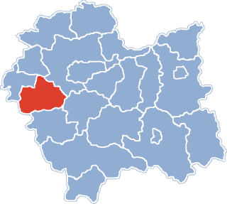
Gmina Wadowice is an urban-rural gmina in Wadowice County, Lesser Poland Voivodeship, in southern Poland. Its seat is the town of Wadowice, which lies approximately 38 kilometres (24 mi) south-west of the regional capital Kraków.

Barwałd Dolny Village in Lesser Poland, Poland

Barwałd Dolny is a village in the administrative district of Gmina Wadowice, within Wadowice County, Lesser Poland Voivodeship, in southern Poland. It lies approximately 6 kilometres (4 mi) east of Wadowice and 35 km (22 mi) south-west of the regional capital Kraków.

Gorzeń Górny Village in Lesser Poland, Poland

Gorzeń Górny is a village in the administrative district of Gmina Wadowice, within Wadowice County, Lesser Poland Voivodeship, in southern Poland. It lies approximately 3 kilometres (2 mi) south-west of Wadowice and 40 km (25 mi) south-west of the regional capital Kraków.

Barwałd Górny Village in Lesser Poland, Poland

Barwałd Górny is a village in the administrative district of Gmina Kalwaria Zebrzydowska, within Wadowice County, Lesser Poland Voivodeship, in southern Poland. It lies approximately 4 kilometres (2 mi) west of Kalwaria Zebrzydowska, 10 km (6 mi) east of Wadowice, and 31 km (19 mi) south-west of the regional capital Kraków.

Brody, Lesser Poland Voivodeship Village in Lesser Poland, Poland

Brody is a village in the administrative district of Gmina Kalwaria Zebrzydowska, within Wadowice County, Lesser Poland Voivodeship, in southern Poland. It lies approximately 2 kilometres (1 mi) east of Kalwaria Zebrzydowska, 15 km (9 mi) east of Wadowice, and 28 km (17 mi) south-west of the regional capital Kraków.

Leńcze Village in Lesser Poland, Poland

Leńcze is a village in the administrative district of Gmina Kalwaria Zebrzydowska, within Wadowice County, Lesser Poland Voivodeship, in southern Poland. It lies approximately 5 kilometres (3 mi) north-east of Kalwaria Zebrzydowska, 16 km (10 mi) east of Wadowice, and 24 km (15 mi) south-west of the regional capital Kraków.

Podolany, Wadowice County Village in Lesser Poland, Poland

Podolany is a village in the administrative district of Gmina Kalwaria Zebrzydowska, within Wadowice County, Lesser Poland Voivodeship, in southern Poland. It lies approximately 9 kilometres (6 mi) north-east of Kalwaria Zebrzydowska, 20 km (12 mi) east of Wadowice, and 21 km (13 mi) south-west of the regional capital Kraków.

Przytkowice Village in Lesser Poland, Poland

Przytkowice is a village in the administrative district of Gmina Kalwaria Zebrzydowska, within Wadowice County, Lesser Poland Voivodeship, in southern Poland. It lies approximately 6 kilometres (4 mi) north of Kalwaria Zebrzydowska, 14 km (9 mi) east of Wadowice, and 25 km (16 mi) south-west of the regional capital Kraków.

Stanisław Dolny Village in Lesser Poland, Poland

Stanisław Dolny is a village in the administrative district of Gmina Kalwaria Zebrzydowska, within Wadowice County, Lesser Poland Voivodeship, in southern Poland. It lies approximately 6 kilometres (4 mi) north-west of Kalwaria Zebrzydowska, 10 km (6 mi) east of Wadowice, and 29 km (18 mi) south-west of the regional capital Kraków.

Zarzyce Małe Village in Lesser Poland, Poland

Zarzyce Małe is a village in the administrative district of Gmina Kalwaria Zebrzydowska, within Wadowice County, Lesser Poland Voivodeship, in southern Poland. It lies approximately 8 kilometres (5 mi) north-east of Kalwaria Zebrzydowska, 20 km (12 mi) east of Wadowice, and 22 km (14 mi) south-west of the regional capital Kraków.

Zarzyce Wielkie Village in Lesser Poland, Poland

Zarzyce Wielkie is a village in the administrative district of Gmina Kalwaria Zebrzydowska, within Wadowice County, Lesser Poland Voivodeship, in southern Poland. It lies approximately 5 kilometres (3 mi) north-east of Kalwaria Zebrzydowska, 17 km (11 mi) east of Wadowice, and 25 km (16 mi) south-west of the regional capital Kraków.

Zebrzydowice, Lesser Poland Voivodeship Village in Lesser Poland, Poland

Zebrzydowice is a village in the administrative district of Gmina Kalwaria Zebrzydowska, within Wadowice County, Lesser Poland Voivodeship, in southern Poland. It lies approximately 6 kilometres (4 mi) north-west of Kalwaria Zebrzydowska, 10 km (6 mi) east of Wadowice, and 29 km (18 mi) south-west of the regional capital Kraków.

Szczyrzyc County was an administrative territorial entity of the Kingdom of Poland and later Polish-Lithuanian Commonwealth. It is unknown when it was established, probably some time in the 14th century. It was located in the southern part of the Kraków Voivodeship, with the capital in the historic village of Szczyrzyc.

Silesian County

Silesian County was an administrative unit (powiat) of both the Kingdom of Poland and the Polish–Lithuanian Commonwealth. With seats in the towns of Zator and Oświęcim, it was part of Kraków Voivodeship.

Poor Clares Church, Bydgoszcz Church in Bydgoszcz, Poland

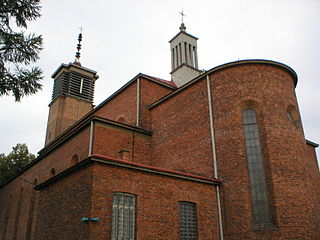
The Church of the Poor Clares dedicated to Assumption of the Blessed Virgin Mary is an historical church in Gdańska Street, Bydgoszcz, Poland.

Assumption of the Blessed Virgin Mary Cathedral, Odessa Church in Odessa, Ukraine

The Assumption of the Blessed Virgin Mary Cathedral also called Cathedral of the Blessed Virgin Mary is the name given to a religious building belonging to the Catholic Church and is located in the city of Odessa in the west part of European country of Ukraine.

References

  1. 1 2 "Central Statistical Office (GUS) - TERYT (National Register of Territorial Land Apportionment Journal)" (in Polish). 2008-06-01.
  2. Adam Dyląg. "Barwałd: W rocznicę tragicznych wydarzeń". Archiwum: W rocznicę tragicznych wydarzeń. Portal dwutygodnika Wolna Droga - Pismo Sekcji Krajowej Kolejarzy. Retrieved 10 February 2014.
  3. J. Studnicki; et al. (2011-10-20). "1944-11-24, Barwałd Średni (śląskie)". Największe katastrofy kolejowe. Towarzystwo Kontroli Rekordów Niecodziennych. Retrieved 8 February 2014.


Coordinates: 49°52′N19°36′E / 49.867°N 19.600°E / 49.867; 19.600

Geographic coordinate system Coordinate system

A geographic coordinate system is a coordinate system that enables every location on Earth to be specified by a set of numbers, letters or symbols. The coordinates are often chosen such that one of the numbers represents a vertical position and two or three of the numbers represent a horizontal position; alternatively, a geographic position may be expressed in a combined three-dimensional Cartesian vector. A common choice of coordinates is latitude, longitude and elevation. To specify a location on a plane requires a map projection.