Basset Mines was a mining company formed in Cornwall, England, by the amalgamation of six copper and tin mining setts. It operated from 1896 until 1918, when it was closed due to a fall in the price of tin.
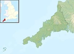
The Basset mines were to the south of Camborne in the parish of Illogan, on the North west side of Carn Brea.[1] The company was formed in 1896 when six different mining setts that had been operated from the 1830s were amalgamated.[2]
The South Wheal Frances, West Wheal Basset and Wheal Basset Mines were all worked for copper in the 18th and 19th centuries.[3] South Wheal Frances adjoins the West Wheal Basset to the north, Wheal Basset to the east and Grenville United to the southwest.[4] South Wheal Frances was named for Frances Basset the only child of Francis Basset (1757–1835), first Lord de Dunstanville and Basset.[5] West Wheal Basset was started as a copper mine in 1835. Sixty years later, as part of Basset Mines, it employed 300 men, 90 women and 30 boys.[5] Wheal Basset is another of the mines that have "Basset" in their name, after the Basset family of Tehidy. Between 1815 and 1900 it produced 94,200 tons of 2.5% copper ore and 13,178 tons of black tin.[6]
Most of the shallow workings were exhausted in the 1820s and 1830s. Steam-powered pumps were used to keep the mines dry as the shafts were sunk deeper.[3] By the 1850s the mines employed several thousand men, women and children.[4] The setts that became the Basset Mines were most profitable in the 1850s and 1860s, extracting copper. Production was cut back in the late 1860s when the price of copper declined, and some mines went below the copper lodes for tin. The tin deposits were deeper and the ores harder to dress than copper, and profits were lower.[7] The Great Flat Lode was reached around 1872–74.[4] This is a large tin deposit to the south of Carn Brea that is tilted at an average angle of about 32 degrees.[8] Most lodes tilt at 60 degrees or more so the lode is relatively flat, hence the name.[9]
The Wheal Basset stamps engine house was built in 1868, with an unusual configuration of two separate beam engines.[10] The new stamps at the West Basset Mine were made by the Tuckingmill Foundry. The settling and buddling floor was opened in 1875. An additional buddle floor opened in 1892.[10] Production of tin steadily grew in the second half of the 19th century, and by the 1880s had overtaken copper.[3]
When the old part of the Wheal Basset sett was stopped, flooding from the mine affected West Basset and West Wheal Frances and old Wheal Basset pumping engine was kept working.[5] A massive pumping engine house was built at Pascoe's Shaft at South Wheal Frances. It held an 80 inches (2,000mm) engine, the largest that the St Austell Foundry ever built, that was started in 1888.[5] The South Wheal Frances company reorganised as South Frances United Mines in 1892.[4] South Frances United included South Wheal Frances and West Wheal Basset, which had been running at a loss for several years.[5] Additional buddles and Cornish frames were erected at West Basset in 1892.[7]
Combined operation
Wheal Bassett
Basset Mines Ltd. was formed in 1896 as a union of South Frances United, Wheal Basset (and North Wheal Basset) and West Wheal Frances Mines.[11] Boundary disputes caused by miners accidentally crossing into the sett of a neighbouring mine were resolved by the merger.[3] After the merger the ore was hoisted at South Wheal Frances and crushed and dressed at West Basset stamps about 1 mile (1.6km) away. The boiler house had a row of six Lancashire boilers and provided steam for the whole operation.[4] A Bruntoncalciner was installed at Wheal Basset stamps in 1897.[10]
Between 1896 and 1899 a major refurbishment of the South Wheal Frances shaft was undertaken, enabling mining down to 6,000 feet (1,800m).[4] By 1900 the Basset Mines manager was no longer able to get the skilled labour need to work the buddles and proposed using vanners[a] in their place. They were installed in a building erected over six of the 1892 buddles just below the stamps.[7] Frue Vanners were installed at the West Basset stamps in 1906. A Frue vanner house was installed below the Wheal Basset stamps in 1908.[10] The "Miner Dry" at Wheal Francis, a building where miners changed from their working clothes after a shift and hung the clothes to dry on large steam pipes, was completed in 1908.[4]
At the time of his death in September 1918 Francis Oats (1848–1918) was chairman of Basset Mines.[13] Basset Mines shut down in December 1918 due to a slump in the price of tin after the end of World War I (1914–18).[4] The company failed in 1919.[2] Total output from the mines before and after the merger was 290,118 tons of copper and 43,134 tons of tin.[3]
West Bassett Stamps
Recent years
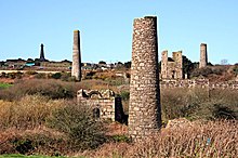
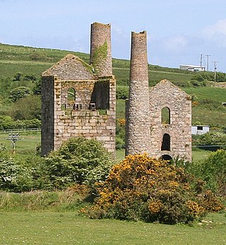
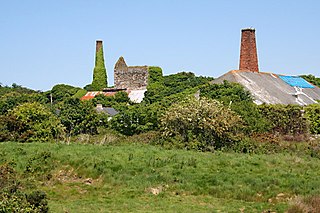
The area was granted World Heritage status on 14 July 2006. The 7.5 miles (12.1km)Great Flat Lode Trail leads around all the major mines in the Camborne-Redruth area, making a circuit of the Carn Brea granite hill, with many information boards explaining the sites. Most of the shafts were plugged by the Kerrier District Council in the 1990s. Many ruined buildings are still accessible to the public.[9] Surviving buildings include the Marriott's Shaft complex of South Wheal Frances, West Basset Stamps and Wheal Basset Stamps. The West Basset Stamps, which had a secondary beam engine to pump water for dressing, stands over an unusually fine example of a 19th-century tin dressing floor. The Marriott's Shaft complex includes the pumping engine house, which held the only inverted beam engine in Cornwall, the houses for the winding, compressor and crusher engines, and the miners' dry.[10]
Notes
↑ A vanner is a mechanical device using water to separate out the ore's components. The Irishman William B. Frue invented an improved device that was widely adopted in the mining industry, known as the Frue vanner.[12]
Bolitho, Bob (11 September 1918), "Death of Mr. F. Oats of St Just", The Cornishman, archived from the original on 13 July 2014, retrieved 17 August 2016{{citation}}: CS1 maint: unfit URL (link)
Media related to Basset Mines at Wikimedia Commons
Related Research Articles
Redruth is a town and civil parish in Cornwall, England, United Kingdom. According to the 2011 census, the population of Redruth was 14,018 In the same year the population of the Camborne-Redruth urban area, which also includes Carn Brea, Illogan and several outlying villages, stood at 55,400 which made it the largest conurbation in Cornwall. Redruth lies approximately at the junction of the A393 and A3047 roads, on the route of the old London to Land's End trunk road, and is approximately 9 miles (14 km) west of Truro, 12 miles (19 km) east of St Ives, 18 miles (29 km) north east of Penzance and 11 miles (18 km) north west of Falmouth. Camborne and Redruth together form the largest urban area in Cornwall and before local government reorganisation were an urban district.
Porthtowan is a small village in Cornwall, England, UK, which is a popular summer tourist destination. Porthtowan is on Cornwall's north Atlantic coast about 3.5 km (2.2 mi) southwest of St Agnes, 6 km (3.7 mi) north of Redruth, 16 km (9.9 mi) west of Truro and 24 km (15 mi) southwest of Newquay in the Cornwall and West Devon Mining Landscape, a World Heritage Site.
Geevor Tin Mine, formerly North Levant Mine is a tin mine in the far west of Cornwall, England, between the villages of Pendeen and Trewellard. It was operational between 1911 and 1990 during which time it produced about 50,000 tons of black tin. It is now a museum and heritage centre left as a living history of a working tin mine. The museum is an Anchor Point of ERIH, The European Route of Industrial Heritage. Since 2006, the mine has been part of the UNESCO World Heritage Site Cornwall and West Devon Mining Landscape.
The Botallack Mine is a former mine in Botallack in the west of Cornwall, UK. Since 2006 it has been part of the UNESCO World Heritage Site – Cornwall and West Devon Mining Landscape. The mine is within the Aire Point to Carrick Du Site of Special Scientific Interest (SSSI) and the South West Coast Path passes along the cliff.
The King Edward Mine at Camborne, Cornwall, in the United Kingdom is a mine wholly owned by Cornwall Council.
Gwennap is a village and civil parish in Cornwall, England, United Kingdom. It is about five miles (8 km) southeast of Redruth. Hamlets of Burncoose, Comford, Coombe, Crofthandy, Cusgarne, Fernsplatt, Frogpool, Hick's Mill, Tresamble and United Downs lie in the parish, as does Little Beside country house.
The Great Flat Lode is a mineral-bearing body of rock under the southern granite slopes of Carn Brea south of Camborne in west Cornwall, UK.
Dolcoath mine was a copper and tin mine in Camborne, Cornwall, United Kingdom. Its name derives from the Cornish for 'Old Ground', and it was also affectionately known as The Queen of Cornish Mines. The site is north-west of Carn Brea. Dolcoath Road runs between the A3047 road and Chapel Hill. The site is south of this road.
Pool is a village in Carn Brea civil parish in west Cornwall, England. It is bypassed by the A30, on the A3047 between Camborne and Redruth, between Tuckingmill and Illogan Highway.
South Crofty is a metalliferous tin and copper mine located in the village of Pool, Cornwall, England. An ancient mine, it has seen production for over 400 years, and extends almost two and a half miles across and 3,000 feet (910 m) down and has mined over 40 lodes. Evidence of mining activity in South Crofty has been dated back to 1592, with full-scale mining beginning in the mid-17th century. The mine went into serious decline after 1985 and eventually closed in 1998. After several changes of ownership, South Crofty is owned by Cornish Metals Inc, which is working to re-open the mine, as of November 2022, having received a permit for dewatering the mine.
Wheal Peevor was a metalliferous mine located on North Downs about 1.5 miles north-east of Redruth, Cornwall, England. The first mining sett was granted here in around 1701 on land owned by the St Aubyn family. It was originally mined at shallow depths for copper, but when the price for that metal slumped after 1788, the mine was able to change to mining tin ore, which was found deeper down. In the late 18th century Wheal Peevor had the advantage of being drained by the Great County Adit which was around 100 metres deep here. The mine covered only 12 acres but had rich tin lodes. In addition to tin and copper, pyrite was also mined here between 1872 and 1887.
Wheal Vor was a metalliferous mine about 2 miles (3.2 km) north west of Helston and 1 mile (1.6 km) north of the village of Breage in the west of Cornwall, England, UK. It is considered to be part of the Mount's Bay mining district. Until the mid-19th century the mine was known for its willingness to try out new innovations. Although very rich in copper and tin ores, the mine never lived up to its expectations. During the later part of the 19th century it had several periods of closure, with an attempt to reopen it in the 1960s which was not successful mainly because of bureaucracy. Today the site is part of the Cornwall and West Devon Mining Landscape.
Wheal Busy, sometimes called Great Wheal Busy and in its early years known as Chacewater Mine, was a metalliferous mine halfway between Redruth and Truro in the Gwennap mining area of Cornwall, England. During the 18th century the mine produced enormous amounts of copper ore and was very wealthy, but from the later 19th century onwards was not profitable. Today the site of the mine is part of the Cornwall and West Devon Mining Landscape, a UNESCO World Heritage Site.
East Pool mine, was a metalliferous mine in the Camborne and Redruth mining area, just east of the village of Pool in Cornwall. Worked from the early 18th century until 1945, first for copper and later tin, it was very profitable for much of its life. Today the site has two preserved beam engines and is part of the Cornwall and West Devon Mining Landscape World Heritage Site. It is owned by the National Trust.
Consolidated Mines, also known as Great Consolidated mine, but most commonly called Consols or Great Consols was a metalliferous mine about a mile ESE of the village of St Day, Cornwall, England. Mainly active during the first half of the 19th century, its mining sett was about 600 yards north–south; and 2,700 yards east–west, to the east of Carharrack. Although always much troubled by underground water, the mine was at times highly profitable, and it was the largest single producer of copper ore in Cornwall. Today the mine is part of the Cornwall and West Devon Mining Landscape World Heritage Site.
Wheal Coates is a former tin mine situated on the north coast of Cornwall, UK, on the cliff tops between Porthtowan and St Agnes. It is preserved and maintained by the National Trust.
Wheal Fortune or Great Wheal Fortune is the site of a mine in the civil parishes of Breage and Sithney in west Cornwall. Part of the disused mine was designated as a Site of Special Scientific Interest (SSSI) for its geological interest in 1991 and is also a Geological Conservation Review site of national importance for the minerals on the site.
Wheal Metal is a tin-mining sett in west Cornwall, England, UK. Whilst not as famous as neighbouring Wheal Vor, it was thus described by the Mining Journal in July 1885: " Truly this is a wonderful mine—probably the richest tin mine in the world." It also hosts a very remarkable engine house of the mid-19th century that once stood over Trelawney's shaft on Wheal Vor, and since the Wheal Vor area itself has no visible remains, this is the only large surviving engine house of this group of mines which accounted for over a quarter of Cornish tin production in the mid-19th century.
The Portreath Tramroad, or alternatively the Portreath Tramway, was opened in 1815, providing a wagonway route from mines near Scorrier in Cornwall, England, to a port at Portreath. From there, it could be transported to market by coastal shipping. It was later extended to serve the Poldice mine near St Day and became known as the Poldice Tramroad, or Poldice Tramway.
South Wheal Frances is a former mine accessing the copper and tin of the Great Flat Lode south of Camborne in Cornwall, England.
This page is based on this Wikipedia article Text is available under the CC BY-SA 4.0 license; additional terms may apply. Images, videos and audio are available under their respective licenses.