
The Great Flat Lode is a mineral-bearing body of rock under the southern granite slopes of Carn Brea south of Camborne in west Cornwall, UK.
The Great Flat Lode is a mineral-bearing body of rock under the southern granite slopes of Carn Brea south of Camborne in west Cornwall, UK.

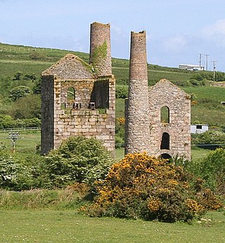
The Great Flat Lode lies under the southern granite slopes of Carn Brea and so named because the tin-bearing rock was at an unusually shallow gradient of about 10 degrees to the horizontal. In other parts of Cornwall mineral bearing lodes lie at between 60 and 90 degrees to the horizontal. "Lode" is a mining term for a mineral vein. Its small gradient allowed for optimal location of the mines. The minerals were accessed by the South Condurrow Mine (later renamed King Edward Mine and used by the Camborne School of Mines), Wheal Grenville, South Wheal Frances Mine and the Bassett Mines. The mines were started to obtain copper ore but at greater depths tin was obtained. [1]
Many of the mines amalgamated and continued production until the First World War.

The Great Flat Lode Trail, a 12 km (7.5 mi) long circular trail around |Carn Brea 50°13′18″N5°14′48″W / 50.22179°N 5.24673°W is one of Cornwall's Mineral Tramway Trails.

Redruth is a town and civil parish in Cornwall, England, United Kingdom. The population of Redruth was 14,018 at the 2011 census. In the same year the population of the Camborne-Redruth urban area, which also includes Carn Brea, Illogan and several satellite villages, stood at 55,400 making it the largest conurbation in Cornwall. Redruth lies approximately at the junction of the A393 and A3047 roads, on the route of the old London to Land's End trunk road, and is approximately 9 miles (14 km) west of Truro, 12 miles (19 km) east of St Ives, 18 miles (29 km) north east of Penzance and 11 miles (18 km) north west of Falmouth. Camborne and Redruth together form the largest urban area in Cornwall and before local government reorganisation were an urban district.

The tin mining industry on Dartmoor, Devon, England, is thought to have originated in pre-Roman times, and continued right through to the 20th century, when the last commercially worked mine closed in November 1930. From the 12th century onwards tin mining was regulated by a stannary parliament which had its own laws.

Geevor Tin Mine, formerly North Levant Mine is a tin mine in the far west of Cornwall, England, between the villages of Pendeen and Trewellard. It was operational between 1911 and 1990 during which time it produced about 50,000 tons of black tin. It is now a museum and heritage centre left as a living history of a working tin mine. The museum is an Anchor Point of ERIH, The European Route of Industrial Heritage. Since 2006, the mine has been part of the UNESCO World Heritage Site Cornwall and West Devon Mining Landscape.

The King Edward Mine at Camborne, Cornwall, in the United Kingdom is a mine wholly owned by Cornwall Council.

Mining in Cornwall and Devon, in the southwest of Britain, is thought to have begun in the early-middle Bronze Age with the exploitation of cassiterite. Tin, and later copper, were the most commonly extracted metals. Some tin mining continued long after the mining of other metals had become unprofitable, but ended in the late 20th century. In 2021, it was announced that a new mine was extracting battery-grade lithium carbonate, more than 20 years after the closure of the last South Crofty tin mine in Cornwall in 1998.

Gwennap is a village and civil parish in Cornwall, England, United Kingdom. It is about five miles (8 km) southeast of Redruth. Hamlets of Burncoose, Comford, Coombe, Crofthandy, Cusgarne, Fernsplatt, Frogpool, Hick's Mill, Tresamble and United Downs lie in the parish, as does Little Beside country house.
The mineral tramways trails are a series of trails located in mid west Cornwall, the trails are as follows:
The Redruth and Chasewater Railway was an early mineral railway line in Cornwall, England, UK. It opened in 1825 and was built to convey the output from copper mines in the Gwennap area to wharves on Restronguet Creek around Devoran, and to bring in coal to fuel mine engines; later it carried timber for pit props and also house coal.

Dolcoath mine was a copper and tin mine in Camborne, Cornwall, United Kingdom. Its name derives from the Cornish for 'Old Ground', and it was also affectionately known as The Queen of Cornish Mines. The site is north-west of Carn Brea. Dolcoath Road runs between the A3047 road and Chapel Hill. The site is south of this road.
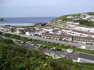
Pool is a village in Carn Brea civil parish in west Cornwall, England. It is bypassed by the A30, on the A3047 between Camborne and Redruth, between Tuckingmill and Illogan Highway.

Tuckingmill is a village in Cornwall, England, United Kingdom, which is in the civil parish of Camborne. Tucking Mill was the Cornish term for a fulling mill which was where homespun cloth was dipped, cleansed and dressed. There is a mention of a fulling mill in this region as early as 1250. The ecclesiastical parish of Tuckingmill was constituted in 1845, being carved out of a western section of the parish of Illogan and an eastern section of Camborne parish. It covers 1,300 acres (5.3 km2).
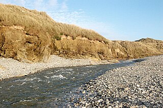
The Red River is a small river in north-west Cornwall, England, United Kingdom which issues into St Ives Bay at Godrevy on Cornwall's Atlantic coast. The Red River is about 8 miles (13 km) long and was given its name from the mineral deposits associated with tin mining, particularly oxides of Iron, which formerly coloured its water red. The river's gradient is relatively steep; the stream falls 170 metres (560 ft) from source to sea.
Wheal Vor was a metalliferous mine about 2 miles (3.2 km) north west of Helston and 1 mile (1.6 km) north of the village of Breage in the west of Cornwall, England, UK. It is considered to be part of the Mount's Bay mining district. Until the mid-19th century the mine was known for its willingness to try out new innovations. Although very rich in copper and tin ores, the mine never lived up to its expectations. During the later part of the 19th century it had several periods of closure, with an attempt to reopen it in the 1960s which was not successful mainly because of bureaucracy. Today the site is part of the Cornwall and West Devon Mining Landscape.

East Pool mine, was a metalliferous mine in the Camborne and Redruth mining area, just east of the village of Pool in Cornwall. Worked from the early 18th century until 1945, first for copper and later tin, it was very profitable for much of its life. Today the site has two preserved beam engines and is part of the Cornwall and West Devon Mining Landscape World Heritage Site. It is owned by the National Trust.

Carnkie is a village in west Cornwall, England, United Kingdom. It is situated approximately one and a half miles south west of Redruth. It is in the civil parish of Carn Brea.
Wheal Fortune or Great Wheal Fortune is the site of a mine in the civil parishes of Breage and Sithney in west Cornwall. Part of the disused mine was designated as a Site of Special Scientific Interest (SSSI) for its geological interest in 1991 and is also a Geological Conservation Review site of national importance for the minerals on the site.
Wheal Metal is a tin-mining sett in west Cornwall, England, UK. Whilst not as famous as neighbouring Wheal Vor, it was thus described by the Mining Journal in July 1885: " Truly this is a wonderful mine—probably the richest tin mine in the world." It also hosts a very remarkable engine house of the mid-19th century that once stood over Trelawney's shaft on Wheal Vor, and since the Wheal Vor area itself has no visible remains, this is the only large surviving engine house of this group of mines which accounted for over a quarter of Cornish tin production in the mid-19th century.
The Portreath Tramroad, or alternatively the Portreath Tramway, was opened in 1815, providing a wagonway route from mines near Scorrier in Cornwall, England, to a port at Portreath. From there, it could be transported to market by coastal shipping. It was later extended to serve the Poldice mine near St Day and became known as the Poldice Tramroad, or Poldice Tramway.

South Wheal Frances is a former mine accessing the copper and tin of the Great Flat Lode south of Camborne in Cornwall, England.

Basset Mines was a mining company formed in Cornwall, England, by the amalgamation of six copper and tin mining setts. It operated from 1896 until 1918, when it was closed due to a fall in the price of tin.
Footnotes
Bibliography
| Unitary authorities | |
|---|---|
| Major settlements (cities in italics) |
|
| Rivers | |
| Topics | |