Kerrier

Last updated

Kerrier District
CornwallKerrier.png
Population
  197378,080 [1]
  200192,536 [2]
History
  Origin
  Created1 April 1974
  Abolished1 April 2009
  Succeeded by Cornwall unitary authority
StatusDistrict
ONS code15UD
GovernmentDistrict council
   HQ Camborne
Kerrierdc.jpg
Subdivisions
  Type Civil parishes
Kerrier Numbered.png

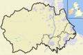
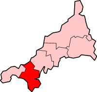
Kerrier (Cornish : Keryer) was a local government district in Cornwall, England, United Kingdom. It was the most southerly district in the United Kingdom, other than the Isles of Scilly. Its council was based in Camborne ( 50°12′50″N5°17′49″W / 50.214°N 5.297°W / 50.214; -5.297 Coordinates: 50°12′50″N5°17′49″W / 50.214°N 5.297°W / 50.214; -5.297 ). Other towns in the district included Redruth and Helston. The district also contained the Lizard Peninsula.

Contents

Kerrier is named after one of the ancient administrative Hundreds of Cornwall, Kerrier, which covered broadly the same area, but did not have a coast on the north.

The district was formed on 1 April 1974, as a merger of the borough of Helston, the urban district of Camborne-Redruth and Kerrier Rural District. On 25 July 2007, Cornwall County Council's bid for unitary authority status was accepted by the government. Kerrier District Council was abolished on 1 April 2009 as part of structural changes to local government in England.

Cornish musician Luke Vibert has released a number of albums and singles under the alias Kerrier District, as a nod to New York musicians Metro Area and a tribute to the place where he grew up.

See also

Related Research Articles

<span class="mw-page-title-main">Mebyon Kernow</span> Political party in Cornwall

Mebyon Kernow – The Party for Cornwall is a Cornish nationalist, centre-left political party in Cornwall, in southwestern Britain. It currently has five elected councillors on Cornwall Council, and several town and parish councillors across Cornwall.

<span class="mw-page-title-main">Redruth</span> Town and civil parish in Cornwall, England

Redruth is a town and civil parish in Cornwall, England. The population of Redruth was 14,018 at the 2011 census. In the same year the population of the Camborne-Redruth urban area, which also includes Carn Brea, Illogan and several satellite villages, stood at 55,400 making it the largest conurbation in Cornwall. Redruth lies approximately at the junction of the A393 and A3047 roads, on the route of the old London to Land's End trunk road, and is approximately 9 miles (14 km) west of Truro, 12 miles (19 km) east of St Ives, 18 miles (29 km) north east of Penzance and 11 miles (18 km) north west of Falmouth. Camborne and Redruth together form the largest urban area in Cornwall and before local government reorganisation were an urban district.

<span class="mw-page-title-main">Camborne</span> Town in Cornwall, England

Camborne is a town in Cornwall, England. The population at the 2011 Census was 20,845. The northern edge of the parish includes a section of the South West Coast Path, Hell's Mouth and Deadman's Cove.

<span class="mw-page-title-main">Falmouth and Camborne (UK Parliament constituency)</span>

Falmouth and Camborne was, from 1950 until 2010, a county constituency represented in the House of Commons of the Parliament of the United Kingdom. It elected one Member of Parliament (MP) by the first past the post system of election.

Camborne-Redruth was an urban district in Cornwall, England, from 1934 to 1974. It was formed as a merger of Camborne and Redruth urban districts along with parts of Redruth Rural District and Helston Rural District. The towns are about four miles apart and form a loose conurbation.

<span class="mw-page-title-main">Camborne and Redruth (UK Parliament constituency)</span> UK Parliament constituency since 2010

Camborne and Redruth is a constituency in Cornwall represented in the House of Commons of the UK Parliament since its creation for the 2010 general election by George Eustice, a Conservative who served as Environment Secretary between 2020 and 2022 under Prime Minister Boris Johnson. The seat is on the South West Peninsula of England, bordered by both the Celtic Sea to the northwest and English Channel to the southeast.

<span class="mw-page-title-main">Penwith Hundred</span> Ancient administrative unit of Cornwall, England

Penwith Hundred was one of ten ancient administrative hundreds of the county of Cornwall, England, UK. The ancient hundred of Penwith was larger than the local government district of Penwith (1974–2009) which took its name. Daphne du Maurier in Vanishing Cornwall suggests that the name, Penwith, has three renderings, "the last promontory," "promontory on the left, and "the headland of slaughter," thus suggesting that this area might have been the site of prehistoric invasions of sea-borne fighters, or perhaps tribal battles. The eastern part became part of Kerrier District.

<span class="mw-page-title-main">Camborne (UK Parliament constituency)</span>

Camborne was a county constituency in Cornwall which returned one Member of Parliament to the House of Commons of the Parliament of the United Kingdom. It was created for the 1885 general election, and abolished for the 1950 general election, when it was largely replaced by the new Falmouth and Camborne.

<span class="mw-page-title-main">Politics of Cornwall</span> South West England county

Cornwall is administered as a county of South West England whose politics are influenced by a number of issues that make it distinct from the general political scene in the wider United Kingdom, and the political trends of neighbouring counties. Its position on the geographical periphery of the island of Great Britain is also a factor.

<span class="mw-page-title-main">Pool, Cornwall</span> Village in west Cornwall, England

Pool is a village in Carn Brea civil parish in west Cornwall, England. It is bypassed by the A30, on the A3047 between Camborne and Redruth, between Tuckingmill and Illogan Highway.

<span class="mw-page-title-main">Scorrier</span> Village in Cornwall, England

Scorrier is a village in Cornwall, England, United Kingdom. It is in the civil parish of St Day, about 2 miles (3 km) northeast of the centre of Redruth and 3 miles (5 km) southeast of the coast at Porthtowan, on the A30 road at the junction of the A3047 road that leads west to Camborne and the B3298 road south to Carharrack. The Plymouth to Penzance railway line passes through the village and between 1852 and 1964 it had its own station. A. E. Rodda & Son, the principal maker of clotted cream is based here.

<span class="mw-page-title-main">Civil parishes in Cornwall</span>

A civil parish is a country subdivision, forming the lowest unit of local government in England. There are 218 civil parishes in the ceremonial county of Cornwall, which includes the Isles of Scilly. The county is effectively parished in its entirety; only the unpopulated Wolf Rock is unparished. At the 2001 census, there were 501,267 people living in the current parishes, accounting for the whole of the county's population. The final unparished areas of mainland Cornwall, around St Austell, were parished on 1 April 2009 to coincide with the structural changes to local government in England.

Kerrier Rural District was a local government division of Cornwall in England, UK, between 1934 and 1974. The rural district was created in 1934 through the abolition of East Kerrier Rural District, Helston Rural District and Redruth Rural District.

Helston Rural District was a local government division of Cornwall in England, UK, between 1894 and 1934. Established under the Local Government Act 1894, the rural district was abolished in 1934 to create Camborne–Redruth Urban District and Kerrier Rural District, as well as enlarging Helston Municipal Borough.

Redruth Rural District was a local government division of Cornwall in England, UK, between 1894 and 1934. Established under the Local Government Act 1894, the rural district was abolished in 1934 to create Camborne–Redruth Urban District and Kerrier Rural District, as well as enlarging Truro Rural District and West Penwith Rural District.

Loveday Elizabeth Trevenen Jenkin is a British politician, biologist and language campaigner. She has been a member of Cornwall Council since 2011, and currently serves as councillor for Crowan, Sithney and Wendron.

<span class="mw-page-title-main">Outline of Cornwall</span> Overview of and topical guide to Cornwall

The following outline is provided as an overview of and topical guide to Cornwall: Cornwall – ceremonial county and unitary authority area of England within the United Kingdom. Cornwall is a peninsula bordered to the north and west by the Celtic Sea, to the south by the English Channel, and to the east by the county of Devon, over the River Tamar. Cornwall is also a royal duchy of the United Kingdom. It has an estimated population of half a million and it has its own distinctive history and culture.

Presented below is an alphabetical index of articles related to Cornwall:

References

  1. Local government in England and Wales: A Guide to the New System. London: HMSO. 1974. p. 38. ISBN   0-11-750847-0.
  2. "Census 2001: Kerrier". Census 2001 . Office for National Statistics. 1 April 2001. Retrieved 5 January 2009.