Caradon District | |
---|---|
![]() | |
Population | |
• 1973 | 58,520 [1] |
• 2001 | 79,647 [2] |
History | |
• Origin |
|
• Created | 1 April 1974 |
• Abolished | 1 April 2009 |
• Succeeded by | Cornwall unitary authority |
Status | District |
ONS code | 15UB |
Government | District council |
• HQ | Liskeard |
![]() | |
Subdivisions | |
• Type | Civil parishes |
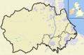
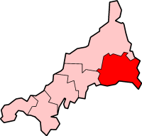
Caradon was a local government district in Cornwall, England, United Kingdom. It contained five towns: Callington, Liskeard, Looe, Saltash and Torpoint, and over 80 villages and hamlets within 41 civil parishes. Its District Council was based in Liskeard 50°27′11″N4°27′54″W / 50.453°N 4.465°W .
The district was formed on 1 April 1974 under the Local Government Act 1972, by the merger of the boroughs of Liskeard and Saltash with the urban districts of Looe and Torpoint, along with Liskeard Rural District and St Germans Rural District.
The district was named after Caradon Hill, the principal landmark of the area, and formerly the site of important copper mines. The district was abolished as part of the 2009 structural changes to local government in England on 1 April.
All of Caradon is included in one of these two hundreds. East Wivelshire and West Wivelshire (usually known merely as East and West) are two of the ancient Hundreds of Cornwall. East and West (Wivelshire) must have originally had a Cornish name but it is not recorded (Wivel arises from the misdivision of Twivelshire, i.e. Two-fold shire). There are also Anglican deaneries by the same names but the modern boundaries do not correspond exactly. The area must have formed one hundred originally but had already been divided into two before the Norman Conquest: they are grouped in Domesday under the head manors of Rillaton (East) and Fawton (West). The Cornish names are: East (Ryslegh); West (Fawy). [3] [4]
Liskeard is an ancient stannary and market town in south-east Cornwall, England, United Kingdom. It is situated approximately 20 miles (32 km) west of Plymouth, 14 miles (23 km) west of the Devon border, and 12 miles (20 km) east of Bodmin. The Bodmin Moor lies to the north-west of the town. The total population of the town at the 2011 census was 11,366
Saltash is a town and civil parish in south Cornwall, England. It had a population of 16,184 in 2011 census. Saltash faces the city of Plymouth over the River Tamar and is popularly known as "the Gateway to Cornwall". Saltash’s landmarks include the Tamar Bridge which connects Plymouth to Cornwall by road, and the Royal Albert Bridge. The area of Latchbrook is part of the town.
The Looe Valley Line is an 8+3⁄4-mile (14 km) community railway from Liskeard to Looe in Cornwall, England, that follows the valley of the East Looe River for much of its course. It is operated by Great Western Railway.
South East Cornwall is a constituency represented in the House of Commons of the UK Parliament since 2010 by Sheryll Murray, a Conservative.
The hundreds of Cornwall were administrative divisions or Shires (hundreds) into which Cornwall, the present day administrative county of England, in the United Kingdom, was divided between c. 925 and 1894, when they were replaced with local government districts.
St Keyne Wishing Well Halt railway station is an intermediate station on the scenic Looe Valley Line in Cornwall, England. It serves the village of St Keyne, and is adjacent to the Magnificent Music Machines museum of fairground organs and similar instruments.
Bodmin was the name of a parliamentary constituency in Cornwall from 1295 until 1983. Initially, it was a parliamentary borough, which returned two Members of Parliament to the House of Commons of England and later the House of Commons of the Parliament of the United Kingdom until the 1868 general election, when its representation was reduced to one member.
Cornwall is administered as a county of South West England whose politics are influenced by a number of issues that make it distinct from the general political scene in the wider United Kingdom, and the political trends of neighbouring counties. Its position on the geographical periphery of the island of Great Britain is also a factor.
East Wivelshire and West Wivelshire are two of the ancient Hundreds of Cornwall.
The Liskeard and Looe Railway was a railway originally built between Moorswater, in the valley west of Liskeard, and Looe, in Cornwall, England, UK, and later extended to Liskeard station on the Cornish Main Line railway. The first section was opened in 1860 and was owned by the Liskeard and Looe Union Canal Company, whose canal had earlier been built to convey sea sand and lime up the valley of the East Looe River, for the purpose of improving agricultural land.
The Forgotten Corner of Cornwall is a geographical area of South East Cornwall, Great Britain. It includes the Rame Peninsula and the town of Torpoint, as well as villages like Antony, Downderry, Polbathic, Portwrinkle and Widegates.
Dobwalls and Trewidland was a civil parish in south-east Cornwall, England, United Kingdom between 1974 and 2021.
Morval is a rural civil parish, hamlet and historic manor in southeast Cornwall, England, United Kingdom. The hamlet is approximately two miles (3 km) north of Looe and five miles (8 km) south of Liskeard.
A civil parish is a country subdivision, forming the lowest unit of local government in England. There are 218 civil parishes in the ceremonial county of Cornwall, which includes the Isles of Scilly. The county is effectively parished in its entirety; only the unpopulated Wolf Rock is unparished. At the 2001 census, there were 501,267 people living in the current parishes, accounting for the whole of the county's population. The final unparished areas of mainland Cornwall, around St Austell, were parished on 1 April 2009 to coincide with the structural changes to local government in England.
Liskeard Rural District was a local government division of Cornwall in England, UK, between 1894 and 1974. Established under the Local Government Act 1894, the rural district was enlarged in 1934 by the abolition of Bodmin Rural District, as well as undergoing a few boundary changes with other adjacent districts.
The following outline is provided as an overview of and topical guide to Cornwall: Cornwall – ceremonial county and unitary authority area of England within the United Kingdom. Cornwall is a peninsula bordered to the north and west by the Celtic Sea, to the south by the English Channel, and to the east by the county of Devon, over the River Tamar. Cornwall is also a royal duchy of the United Kingdom. It has an estimated population of half a million and it has its own distinctive history and culture.
Presented below is an alphabetical index of articles related to Cornwall: