
Bedfordshire is a ceremonial county in the East of England. It is bordered by Northamptonshire to the north, Cambridgeshire to the north-east, Hertfordshire to the south and the south-east, and Buckinghamshire to the west. The largest settlement is Luton (225,262), and Bedford is the county town.

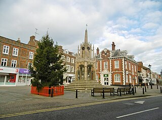
Leighton Buzzard is a market town in Bedfordshire, England, in the southwest of the county and close to the Buckinghamshire border. It lies between Aylesbury, Tring, Luton/Dunstable and Milton Keynes, near the Chiltern Hills.

Bedfordshire is an English ceremonial county which lies between approximately 25 miles and 55 miles north of central London.

A civil parish is a country subdivision, forming the lowest unit of local government in England. There are 125 civil parishes in the ceremonial county of Bedfordshire, most of the county being parished: Luton is completely unparished; Central Bedfordshire is entirely parished. At the 2001 census, there were 312,301 people living in the 125 parishes, which accounted for 55.2 per cent of the county's population.

South West Bedfordshire was a constituency represented in the House of Commons of the UK Parliament. As with all constituencies of the UK Parliament, it elected one Member of Parliament (MP) by the first past the post system of election.

Luton Rural District was a local authority in Bedfordshire, England from 1894 to 1974. It covered an area which almost surrounded but did not include the towns of Luton and Dunstable.
Luton was a constituency including the town of Luton in Bedfordshire. It returned one Member of Parliament (MP) to the House of Commons of the UK Parliament from 1885 to 1974, elected by the first past the post system.
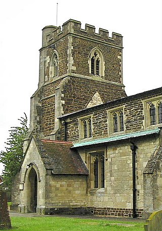
Stanbridge is a village and civil parish in Bedfordshire which lies 3 miles (5 km) east of Leighton Buzzard. It also borders the Bedfordshire villages of Hockliffe, Eggington, Tilsworth, Totternhoe and Billington.

South Bedfordshire was a county constituency in Bedfordshire. It returned one Member of Parliament (MP) to the House of Commons of the Parliament of the United Kingdom, elected by the first past the post system.

Luton Borough Council, also known as Luton Council, is the local authority of Luton, in the ceremonial county of Bedfordshire, England. Luton has had an elected local authority since 1850, which has been reformed several times. Since 1997 the council has been a unitary authority, being a district council which also performs the functions of a county council.

Dunstable is a market town and civil parish in Bedfordshire, England, east of the Chiltern Hills, 30 miles north of London. There are several steep chalk escarpments, most noticeable when approaching Dunstable from the north. Dunstable is the fourth largest town in Bedfordshire and along with Houghton Regis forms the westernmost part of the Luton/Dunstable urban area.
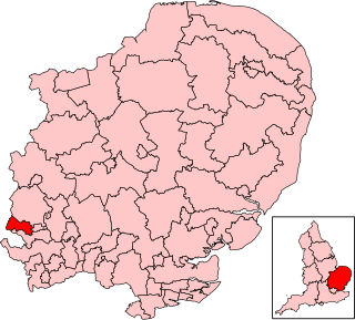
Central Bedfordshire is a unitary authority area in the ceremonial county of Bedfordshire, England. It was created in 2009.
Mark Anthony Gaius Versallion is a British politician, businessman, and officer in the Royal Naval Reserve. He was the Conservative prospective parliamentary candidate for Stretford and Urmston from 2007 to 2009 and from 2009 to 2011 was Chairman of the Foreign Affairs Forum of the Conservative Party. Since 2011 he has been a member of Central Bedfordshire unitary authority.

Central Bedfordshire Council is the local authority for Central Bedfordshire, a local government district in the ceremonial county of Bedfordshire, England. The council is a unitary authority, being a district council which also performs the functions of a county council. It has been under no overall control since 2023, being run by an independent-led administration. The council is based at Chicksands.

The Luton-Dunstable Busway is a guided busway system in Bedfordshire, England, which connects the towns of Dunstable, Houghton Regis and Luton with Luton Airport. It was built on the route of a disused railway track and opened in September 2013. The busway runs parallel to the A505 and A5065 for 13.4 kilometres (8.3 mi), of which 7.7 kilometres (4.8 mi) is guided track with a maximum speed of 50 mph. It is claimed to be the second longest busway in the world.

The 2011 Central Bedfordshire Council electionfor the Central Bedfordshire Council were held on 5 May 2011, along with other United Kingdom local elections. The whole council was up for election following boundary changes, with each successful candidate serving a four-year term of office, expiring in 2015.
Dunstable and Leighton Buzzard is a constituency of the House of Commons in the UK Parliament. It was first contested at the 2024 general election. The current MP is Alex Mayer of the Labour Party.


