Restormel

Last updated

Borough of Restormel
Fowey valley.jpg
CornwallRestormel.png
Population
  197373,080 [1]
  200195,547 [2]
History
  Origin
  Created1 April 1974
  Abolished1 April 2009
  Succeeded by Cornwall Council unitary authority
StatusBorough
ONS code15UA
GovernmentBorough council
   HQ St Austell
   Motto Ro an mor hag an tyr
Restormel Borough Council crest.png
Subdivisions
  Type Civil parishes
Restormelmap.gif

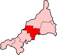
Restormel (Cornish : Rostorrmel) [3] was a borough of Cornwall, England, one of the six administrative divisions that made up the county. Its council was based in St Austell 50°20′17″N4°47′31″W / 50.338°N 4.792°W / 50.338; -4.792 ; its other towns included Newquay.

Contents

The borough was named after Restormel Castle. It was formed on 1 April 1974, under the Local Government Act 1972, by a merger of the borough of St. Austell with Fowey, Newquay urban district and St Austell Rural District. The name Restormel comes from Cornish, meaning the king's tower hill. [4]

The motto of the borough, in Cornish, is Ro an mor hag an tyr, meaning "From the sea and from the land". It recognises the borough's connection with the sea (fishing and tourism) and the land (china clay and agriculture). St Austell, the largest settlement in Cornwall, did not have a Parish/Town Council.

The district was abolished as part of the 2009 structural changes to local government in England on 1 April 2009.

Twinning

Restormel is twinned by oath, which used to be accessible to view in the council offices [5] in St Austell, with Kreis Dithmarschen. This used to be part of the borough council; however, in recent years it has become a separate organisation.[ clarification needed ]

Council investments

In March 2009, Restormel Borough Council was accused by spending watchdog the Audit Commission of "negligence" for putting money into Icelandic banks days before they went bust in October 2008. [6] [7]

See also

Related Research Articles

<span class="mw-page-title-main">Cornwall</span> Ceremonial county in England

Cornwall is a ceremonial county in South West England. It is recognised by Cornish and Celtic political groups as one of the Celtic nations, and is the homeland of the Cornish people. The county is bordered by the Atlantic Ocean to the north and west, Devon to the east, and the English Channel to the south. The largest urban area in the county is a conurbation that includes the former mining towns of Redruth and Camborne, and the county town is the city of Truro.

<span class="mw-page-title-main">Newquay</span> Town in Cornwall, England

Newquay is a town on the north coast in Cornwall, England, United Kingdom. It is a civil parish, seaside resort, regional centre for aerospace industries with an airport and a spaceport, and a fishing port on the North Atlantic coast of Cornwall, approximately 12 miles (19 km) north of Truro and 20 miles (32 km) west of Bodmin.

<span class="mw-page-title-main">Fowey</span> Town in Cornwall, England

Fowey is a port town and civil parish at the mouth of the River Fowey in south Cornwall, England, United Kingdom. The town has been in existence since well before the Norman invasion, with the local church first established some time in the 7th century; the estuary of the River Fowey forms a natural harbour which enabled the town to become an important trading centre. Privateers also made use of the sheltered harbourage. The Lostwithiel and Fowey Railway brought China clay here for export.

<span class="mw-page-title-main">St Austell</span> Town in Cornwall, England

Saint Austell is a town in Cornwall, England, United Kingdom, 10 miles (16 km) south of Bodmin and 30 miles (48 km) west of the border with Devon.

<span class="mw-page-title-main">Lostwithiel</span> Town in Cornwall, England

Lostwithiel is a civil parish and small town in Cornwall, England, United Kingdom at the head of the estuary of the River Fowey. According to the 2001 census it had a population of 2,739, increasing to 2,899 at the 2011 census. The Lostwithiel electoral ward had a population of 4,639 at the 2011 census. The name Lostwithiel comes from the Cornish "lostwydhyel" which means "tail of a wooded area".

<span class="mw-page-title-main">Charlestown, Cornwall</span> Human settlement in England

Charlestown is a village and port on the south coast of Cornwall, England, in the civil parish of St Austell Bay. It is situated approximately 2 miles (3 km) southeast of St Austell town centre.

<span class="mw-page-title-main">North Cornwall (UK Parliament constituency)</span> Parliamentary constituency in the United Kingdom, 1918 onwards

North Cornwall is a constituency represented in the House of Commons of the UK Parliament by Ben Maguire, a Liberal Democrat since the 2024 general election. Like all British constituencies, the seat elects one Member of Parliament (MP) by the first past the post system of election at least every five years. The seat was created in 1918. Since 1950, the constituency has been held by MPs from either the Conservative Party or the Liberal Democrats.

<span class="mw-page-title-main">Grampound</span> Human settlement in England

Grampound is a village and former civil parish, now in the parish of Grampound with Creed, in the Cornwall district, in the ceremonial county of Cornwall, England. It is at an ancient crossing point of the River Fal and today is on the A390 road six miles (10 km) west of St Austell and eight miles (13 km) east of Truro. In 1961 the parish had a population of 412.

Dick Cole is a Cornish politician, currently serving as an elected member of Cornwall Council and the leader of the Cornish devolutionist political party, Mebyon Kernow, a role he has held since 1997. He is currently one of the longest serving political leaders in Britain. Dick Cole was first elected MK leader in 1997.

St Austell with Fowey was a municipal borough in Cornwall, United Kingdom. It was created in 1968 by a merger of the historic borough of Fowey and the much more populous St Austell urban district. 50.338°N 4.794°W

<span class="mw-page-title-main">St Austell and Newquay (UK Parliament constituency)</span> Parliamentary constituency in the United Kingdom, 2010 onwards

St Austell and Newquay is a constituency in Cornwall represented in the House of Commons of the UK Parliament since 2024 by Noah Law, a Labour MP. It is on the South West Peninsula of England, bordered by both the Celtic Sea to the northwest and English Channel to the southeast.

Restormel was a non-metropolitan district in Cornwall, England. It was abolished on 1 April 2009 and replaced by Cornwall Council.

<span class="mw-page-title-main">Politics of Cornwall</span> South West England county

Cornwall is administered as a county of South West England whose politics are influenced by a number of issues that make it distinct from the general political scene in the wider United Kingdom, and the political trends of neighbouring counties. Its position on the geographical periphery of the island of Great Britain is also a factor.

The Newquay Voice is a local weekly newspaper, launched in September 2001 by Andrew and Chrissie Laming, that publishes every Wednesday from Newquay, Cornwall, United Kingdom covering the northern part of the former borough of Restormel. The paper has five editorial staff including a full-time photographer and sport editor. The paper is edited by Simon Fernley, a journalist with more than 20 years experience of the patch who was, prior to joining the Voice, sub-editor at the Cornish Guardian.

<span class="mw-page-title-main">Truro and St Austell (UK Parliament constituency)</span> UK Parliament constituency, 1997 to 2010

Truro and St Austell was a county constituency in Cornwall represented in the House of Commons of the UK Parliament from its 1997 creation to its 2010 abolition by Matthew Taylor of the Liberal Democrats, who was appointed a life peer in the House of Lords following his service as a Member of Parliament (MP). The constituency elected one MP by the first past the post system of election.

<span class="mw-page-title-main">Civil parishes in Cornwall</span>

A civil parish is a country subdivision, forming the lowest unit of local government in England. There are 218 civil parishes in the ceremonial county of Cornwall, which includes the Isles of Scilly. The county is effectively parished in its entirety; only the unpopulated Wolf Rock is unparished. At the 2001 census, there were 501,267 people living in the current parishes, accounting for the whole of the county's population. The final unparished areas of mainland Cornwall, around St Austell, were parished on 1 April 2009 to coincide with the structural changes to local government in England.

<span class="mw-page-title-main">Steve Double</span> British Conservative politician

Stephen Daniel Double is a British Conservative Party politician. He was the Member of Parliament (MP) for St Austell and Newquay from 2015 until 2024 when he was defeated in the 2024 United Kingdom general election by Labour candidate Noah Law. He served as a junior Lord Commissioner of the Treasury from 28 October 2022 to 13 November 2023.

<span class="mw-page-title-main">Outline of Cornwall</span> Overview of and topical guide to Cornwall

The following outline is provided as an overview of and topical guide to Cornwall: Cornwall – ceremonial county and unitary authority area of England within the United Kingdom. Cornwall is a peninsula bordered to the north and west by the Celtic Sea, to the south by the English Channel, and to the east by the county of Devon, over the River Tamar. Cornwall is also a royal duchy of the United Kingdom. It has an estimated population of half a million and it has its own distinctive history and culture.

Presented below is an alphabetical index of articles related to Cornwall:

Mount Charles was an electoral division of Cornwall in the United Kingdom which returned one member to sit on Cornwall Council between 2009 and 2021. It was abolished at the 2021 local elections, being absorbed into St Austell Poltair and Mount Charles, St Austell Central and Gover, and St Austell Bethel and Holmbush

References

  1. Local government in England and Wales: A Guide to the New System. London: HMSO. 1974. p. 38. ISBN   0-11-750847-0.
  2. "Census 2001: Restormel". Census 2001 . Office for National Statistics. 1 April 2001. Retrieved 5 January 2009.
  3. Place-names in the Standard Written Form (SWF)  : List of place-names agreed by the MAGA Signage Panel. Cornish Language Partnership.
  4. Drew, Samuel (1824). The History of Cornwall: From the earliest Records and Traditions, to the Present Time. W. Penaluna. p. 396.
  5. "Council plans for St Austell town centre hub". BBC News. 26 March 2023. Retrieved 29 July 2023.
  6. "Councils 'ignored Iceland risks'". BBC News . 26 March 2009. Retrieved 23 December 2023.
  7. John Carvel (26 March 2009). "Councils were negligent in making Icelandic deposits, rules watchdog". The Guardian . Retrieved 23 December 2023.