
Fowey is a port town and civil parish at the mouth of the River Fowey in south Cornwall, England, United Kingdom. The town has been in existence since well before the Norman invasion, with the local church first established some time in the 7th century; the estuary of the River Fowey forms a natural harbour which enabled the town to become an important trading centre. Privateers also made use of the sheltered harbourage. The Lostwithiel and Fowey Railway brought China clay here for export.

The Saints' Way is a long-distance footpath in mid Cornwall, England, UK.

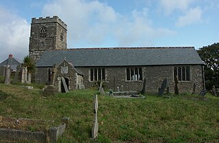
Lanreath is a civil parish and a village in southeast Cornwall, England, United Kingdom. The village is situated five miles (8 km) west-northwest of Looe. The name Lanreath means 'church (Lann) of Raydhogh' and it has been known variously as Lanreythow, Lanrathew, or Lanrethou. The village is mentioned in the Domesday Book as Lanredoch.

St Wenn is a civil parish and village in Cornwall, England, United Kingdom. The village is situated six miles (10 km) west of Bodmin and nine miles (14.5 km) east of Newquay. The parish population at the 2011 census was 369.
St Clether is a civil parish and village in Cornwall, England, United Kingdom. The village is situated on the east flank of Bodmin Moor approximately eight miles (13 km) west of Launceston in the valley of the River Inny. The population of the civil parish at the 2011 census was 156.

Mawnan is a village and civil parish in south Cornwall, England, United Kingdom. It is in the former administrative district of Kerrier and is bounded to the south by the Helford River, to the east by the sea, and to the west by Constantine parish. The population was 1,454 in the 2001 census, rising slightly to 1,476 at the 2011 census. The church town of the parish is Mawnan Church, also known simply as Mawnan, and the only large village in the parish is Mawnan Smith, approximately three miles south of Falmouth.

Manaccan is a civil parish and village on the Lizard peninsula in south Cornwall, England, United Kingdom. The village is about five miles (8 km) south-southwest of Falmouth.

St Veep is a civil parish in Cornwall, England, United Kingdom, situated above the east bank of the River Fowey about three miles (5 km) south-east of Lostwithiel. It is bordered by the parishes of St Winnow to the north-west, Boconnoc to the north, Lanreath to the east Polperro to the south-east and Lanteglos to the south. The River Fowey forms its western boundary. The parish is named after Saint Veep of whom little is known.

St Anthony-in-Meneage is a coastal civil parish and village in Cornwall, England, United Kingdom. The parish is in the Meneage district of the Lizard peninsula. In the 2001 census the parish had a population of 171, decreasing to 168 at the 2011 census.

St Winnow is a civil parish in Cornwall, England, United Kingdom. Its name may be connected with either that of Saint Winnoc or Saint Winwaloe. It has a population of 304, which had increased to 328 at the 2011 census. The church town is on the east bank of the River Fowey south of Lostwithiel. Part of the village of Lerryn lies within the parish as does the Chapel of St Nectan. The Redlake Meadows & Hoggs Moor, a Site of Special Scientific Interest is also in the parish.

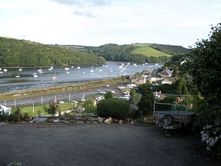
Bodinnick is a riverside village in south-east Cornwall, in the United Kingdom. According to the Post Office the population of the 2011 Census was included in the civil parish of Lanteglos-by-Fowey. It is a fishing village situated on the east bank of the River Fowey opposite the town of Fowey, also on the banks of the Fowey River. The ferry crossing is from Fowey to Bodinnick and the "Old Ferry Inn" is located on its bank glorified as "in the heart of Du Maurier country". This ferry terminal is said to have existed since the 13th century.

Week St Mary is a village and civil parish in northeast Cornwall, England, United Kingdom. It is situated south of Bude close to the River Tamar and the border between Cornwall and Devon in the Hundred of Stratton. The parish population at the 2011 census is 657.
St Sampson's Church is the Church of England parish church of the village of Golant, Cornwall, England, United Kingdom; it is dedicated to St Sampson of Dol.
Golant is a village in south Cornwall, England, United Kingdom. It is on the west bank of the River Fowey and in the civil parish of St Sampson.

Forrabury and Minster is a civil parish on the north coast of Cornwall, England, United Kingdom. The parish was originally divided between the coastal parish of Forrabury and inland parish of Minster until they were united on the 1st of April 1919.
St Thomas the Apostle Rural, also known as St Thomas-by-Launceston is a civil parish in east Cornwall, England, United Kingdom. It is centred on the village of Tregadillett and is in the Registration District of Launceston.

Warleggan or Warleggon is a civil parish on the southern edge of Bodmin Moor in Cornwall, England, United Kingdom.

Lansallos is a village in the civil parish of Polperro in south Cornwall, England, United Kingdom. It is situated between Polruan and Polperro about 5 miles (8 km) east of Fowey in Liskeard Registration District.

Lanteglos is a coastal civil parish in south Cornwall, England, United Kingdom. It is on the east side of the tidal estuary of the River Fowey which separates it from the town and civil parish of Fowey. The South West Coast Path runs along the southern coasts of the parish and much of the southern part of the parish lies in the Polruan to Polperro Site of Special Scientific Interest managed by the National Trust.

St Dominic is a civil parish and village in Cornwall, England, United Kingdom. The village is situated 2+1⁄2 miles (4.0 km) east of Callington and five miles (8 km) north of Saltash.

