
Northumberland is a ceremonial county in North East England, bordering Scotland. It is bordered by the Scottish Borders to the north, the North Sea to the east, Tyne and Wear and County Durham to the south, and Cumbria to the west. The town of Blyth is the largest settlement. Northumberland is the northernmost county in England.
North Tyneside is a metropolitan borough in the metropolitan county of Tyne and Wear, England. It forms part of the greater Tyneside conurbation. North Tyneside Council is headquartered at Cobalt Park, Wallsend.

Castle Morpeth was a local government district and borough in Northumberland, England. Its administrative centre was the town of Morpeth.

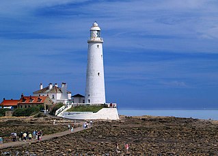
Blyth is a port and seaside town as well as a civil parish in southeast Northumberland, England. It lies on the coast, to the south of the River Blyth. It has a population of 39,731 as of the 2021 census, up 6% from the 2011 census and population of 37,347.
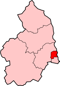
Wansbeck was a local government district in south-east Northumberland, England. Its main population centres were Ashington, Bedlington and Newbiggin-by-the-Sea.

Tynedale was a local government district in Northumberland, England. The district had a resident population of 58,808 according to the 2001 census. The main towns were Hexham, Haltwhistle and Prudhoe. The district contained part of Hadrian's Wall and the southern part of Northumberland National Park.
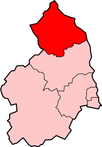
Berwick-upon-Tweed was a local government district and borough in Northumberland in the north-east of England, on the border with Scotland. The district had a resident population of 25,949 according to the 2001 census, which also notes that it is the most ethnically homogeneous in the country, with 99.6% of the population recording themselves in the 2001 census as White. It was also the least populated district in England with borough status, and the third-least densely populated local government district.

Wansbeck was a constituency in Northumberland in the House of Commons of the UK Parliament. It was represented from its 1983 re-creation until its abolition for the 2024 general election by members of the Labour Party.

Blyth Valley, formerly known as Blyth, was a constituency most recently represented in the House of Commons of the UK Parliament from 2019 by Ian Levy, a Conservative until its abolition in 2024.

Seaton Delaval is a village and former civil parish, now in the parish of Seaton Valley, in Northumberland, England, with a population of 4,371. The largest of the five villages in Seaton Valley, it is the site of Seaton Delaval Hall, completed by Sir John Vanbrugh in 1727.

Seaton Valley was an urban district in Northumberland, England, from 1935 to 1974, at which point it was split between the districts of North Tyneside and Blyth Valley.
Blyth Valley Borough Council elections were generally held every four years between the council's creation in 1974 and its abolition in 2009. Blyth Valley was a non-metropolitan district in Northumberland, England. The council was abolished and its functions transferred to Northumberland County Council with effect from 1 April 2009.

Northumberland County Council is the local authority for the non-metropolitan county of Northumberland in North East England. Since 2009 it has been a unitary authority, having also taken over district-level functions when the county's districts were abolished.
Tynemouth was a rural district in the English county of Northumberland.

The Tyneside Passenger Transport Executive was the operations arm of the Tyneside Passenger Transport Authority, created by the Transport Act 1968. and came into operation on 1 January 1970.

North Tyneside Council, or North Tyneside Metropolitan Borough Council, is the local authority for the metropolitan borough of North Tyneside in Tyne and Wear, England. It is a metropolitan borough council and provides the majority of local government services in the borough. The council has been a member of the North East Combined Authority since 2024.
The county of Northumberland has returned four MPs to the UK Parliament since 1983. Under the 2023 review of Westminster constituencies, coming into effect for the 2024 general election, the boundary commission proposed that two of the four constituencies be shared with the county of Tyne and Wear.

Cramlington and Killingworth is a constituency of the House of Commons in the UK Parliament. Further to the completion of the 2023 Periodic Review of Westminster constituencies, it was first contested at the 2024 general election and is currently held by Emma Foody, a Labour and Co-operative MP.


