The district covered much of the Weardale area. In the west it was parished and rural, whereas in the east it was more urban. Crook and Willington are unparished.
Willington is a village and former civil parish, now in the parish of Greater Willington, in County Durham and the ceremonial county of Durham, England. Willington stands in the foothills of the Pennines and near the River Wear close to Crook, Bishop Auckland and Durham.
County Durham, officially simply Durham (/ˈdʌrəm/), is a ceremonial county in North East England. The county borders Northumberland and Tyne and Wear to the north, the North Sea to the east, North Yorkshire to the south, and Cumbria to the west. The largest settlement is Darlington.
Chester-le-Street was a local government district in County Durham, England. Its council was based in Chester-le-Street. Other places in the district included Great Lumley and Sacriston.
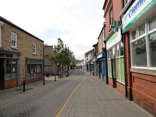
Crook is a market town in the Durham County Council unitary authority and ceremonial county of County Durham, England. It is located on the edge of Weardale and sometimes referred to as the "Gateway to Weardale".
Witton-le-Wear is a village in County Durham, North East England. It is situated on the north bank of the River Wear, 6 km (3.7 mi) to the north-west of Bishop Auckland.
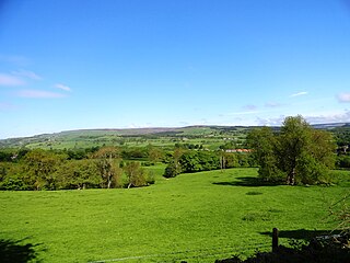
Weardale is a dale, or valley, on the east side of the Pennines in County Durham, England. Large parts of Weardale fall within the North Pennines Area of Outstanding Natural Beauty (AONB) – the second-largest AONB in England and Wales. The upper dale is surrounded by high fells and heather grouse moors. The River Wear flows through Weardale before reaching Bishop Auckland and then Durham, meeting the sea at Sunderland.
Helmington Row is a small village in County Durham, England. It is situated between Crook and Willington, about 7 miles south-west of Durham and 3 miles north-north-west of Bishop Auckland.
Escomb is a village and former civil parish on the River Wear about 1+1⁄2 miles (2.4 km) west of Bishop Auckland, in the County Durham district, in the ceremonial county of Durham, England. In 2001 it had a population of 358. In 2011 the ward had a population of 3323.
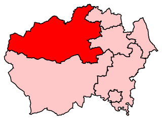
North West Durham was a constituency represented in the House of Commons of the UK Parliament.
Bishop Auckland is a constituency in County Durham that is represented in the House of Commons since 2024 by Sam Rushworth of the Labour Party.
Crook and Willington was an urban district in County Durham, England from 1937 to 1974. It was created by a merger of the previous Crook and Willington urban districts, along with part of the disbanded Auckland Rural District. It later formed part of the Wear Valley district. Today the population of this area is approximately 21,500.The area Includes Crook, Willington, Sunnybrow, Helmington Row, Billy Row and Roddymoor
Weardale was a rural district in County Durham, England from 1894 to 1974. It was formed under the Local Government Act 1894 as a successor to the Weardale rural sanitary district.
Barnard Castle was a county constituency centred on the town of Barnard Castle in County Durham, which returned one Member of Parliament (MP) to the House of Commons of the Parliament of the United Kingdom. It was created for the 1885 general election and abolished for the 1950 general election.
Spennymoor was a county constituency centred on the town of Spennymoor in County Durham. It returned one Member of Parliament (MP) to the House of Commons of the Parliament of the United Kingdom, elected by the first past the post system from 1918 to 1950.
The Durham to Bishop Auckland Line was a railway line originally built by the North Eastern Railway (NER) to provide rail transport access to coal mines in West County Durham. It closed under the Beeching Axe to passenger traffic in May 1964, and freight in 1968. Today it forms the major part of the 9 miles (14 km) Brandon to Bishop Auckland rail trail.
Crook railway station served the town of Crook, County Durham, England. It was located on the Bishop Auckland and Weardale Railway line from Bishop Auckland to Blackhill between Wear Valley Junction and Tow Law.
Wear Valley Junction railway station primarily served as an interchange between the Wear Valley Line and the Weardale Extension Railway (WXR) between 1847 and 1935. It was the closest railway station to the village of High Grange in County Durham, North East England.
The county of Durham returned 7 MPs to the UK Parliament from 1983 to 2024. Under the 2023 review of Westminster constituencies, coming into effect for the 2024 general election, the boundary commission proposed that one constituency be shared with the county of Tyne and Wear. In addition, the unitary authority of Darlington, which had previously been included with Durham, was now included with the four unitary authorities which make up the former county of Cleveland. For the purposes of this series of articles, Darlington continues to be included with Durham.
This page is based on this Wikipedia article Text is available under the CC BY-SA 4.0 license; additional terms may apply. Images, videos and audio are available under their respective licenses.