Derwentside

Last updated

Derwentside
DurhamDerwentside.png
Shown within non-metropolitan County Durham
Area
  1974 [1] 66,944 acres (270.91 km2)
Population
  1973 [1] 91,460
  1992 [2] 87,200
  2001 [3] 85,074
History
  Created1974
  Abolished2009
  Succeeded by County Durham
StatusDistrict
ONS code 20UD
GovernmentDurham County Council
   HQ Consett
   Motto Donec Defluet Amnis (Until the river ceases to flow)
Derwentside arms.png

Derwentside was, from 1974 to 2009, a local government district in County Durham, England.

Contents

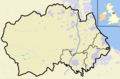
The district took its name from the River Derwent, which made up part of the northern border of the district. Its main towns were Consett and Stanley, with the district council offices on Consett's Medomsley Road. The rest of the district was semi-rural, with numerous former pit villages running into one another.

Formation

The district was formed on 1 April 1974 under the Local Government Act 1972, which reorganised local administration throughout England and Wales. The district was a merger of three abolished districts: [1]

Derwentside was one of eight districts into which County Durham was divided in 1974. It was bounded on the east by Chester-le-Street District, to the south-east by the City of Durham and to the south and west by Wear Valley District. To the north the district was bounded by the Metropolitan County of Tyne and Wear and to the north west by Northumberland. [1]

Economy

Derwentside's economy was traditionally based on the steel industry and coal mining. With the loss of these industries, the district struggled with unemployment, although European Union funding provided a boost to local businesses and visitor attractions.[ citation needed ]

Elections and political control

The first election to Derwentside District Council took place on 7 June 1973, with the 55 councillors elected forming a shadow authority until 1 April 1974. [1] [4] Elections of the whole council were next held in 1976, and every four years thereafter. [5] Throughout the council's existence it was controlled by the Labour Party, initially with very large majorities. The main opposition group were the Derwentside Independents. At the final election prior to abolition, held in 2007, Labour's majority was reduced to only three seats. [6]

YearConservativeLabourLiberal/
Liberal Democrat
IndependentOther
1973 [4] 145333
1976 [5] 2 (+1)39 (−6)5 (+2)9 (+3)0
1979 [7] 6313150
1983 [8] 4 (−2)36 (+3)212 (−1) SDP 1
1987 [9] 3 (−1)43 (+5)0 (−1)9 (−2)SDP 0 (−1)
1991 [10] 2390140
1995 [11] 0 (−2)50 (+11)05 (−9)0
1999 [12] 047080
2003 [13] 0381 (+1)16 (+8)0
2007 [6] 029 (−11)2 (+1)24 (+10)0

Coat of arms

Derwentside District Council were granted armorial bearings by the College of Arms in 1975. The letters patent were dated 8 May 1975, and the arms were blazoned as follows: [14]

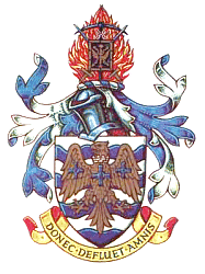
Barry wavy of eight Argent and Azure an Eagle displayed wings inverted Or gorged with a Mural Crown proper pendent therefrom by a ring a Cross of St. Cuthbert and charged on each wing with a like Cross Azure.

Crest: On a wreath of the colours In front of Flames a Miner's Pick head upwards in pale and two Swords points upwards in Saltire proper hilts and pomels Or pendent from the Pick by a Chain Argent a Roman Shield Sable charged with a Thunderbolt and on a Bordure Or ten Pellets.

Badge:A Fountain charged with an Eagle as in the Arms.

The shield had a field of silver and blue waves, representing the Rivers Derwent, Deerness and Browney. On top of this was placed a Roman eagle, for the Roman settlements at Ebchester, Lanchester, Dere Street and Stanley. About the eagle's neck was a mural crown representing a city wall, and thus local government. On the eagle's breast and wings were three crosses of Saint Cuthbert, patron saint of Durham: these suggested the union of three County Durham councils in one. [14]

Upon a helm with torse and mantling was the crest. The swords and flames stood for the steel industry and the pickaxe for coalmining. Hanging from the axe was a Roman shield bearing a thunderbolt for the broadcasting station at Pontop Pike. [14]

The Latin motto was Donec Defluet Amnis or Until the river ceases to flow. It was adapted from the writings of the Roman poet Horace. [14]

Town Twinning

Derwentside district was twinned with Werdohl in Germany.[ citation needed ]

Abolition

The district was abolished as part of the 2009 structural changes to local government in England. On 1 April 2009 the two-tier system of administration in County Durham was replaced, with a unitary Durham County Council replacing both the existing county council and district councils. [15]

In 2009, Durham County Council unveiled plans for the regeneration of Consett. These plans involved the demolition of the former headquarters of Derwentside District Council at Consett Civic Centre and the relocation of Consett AFC to Crookhall. The site was to be redeveloped and the new Consett Academy built there. [16]

On 5 July 2010, the Secretary of State for Education announced plans for the overhaul of England's school building programme. The announcement stated that it would be "irresponsible to carry on regardless with an inflexible, and needlessly complex programme." [17] Many building programmes that had not commenced were cancelled but the plans for Consett Academy and an academy at nearby Stanley were "for discussion."

Local opponents to the building of an academy on the Belle Vue site in Consett launched an application to have the land registered as a village green. This would prohibit the development of the land. A public inquiry was held at Consett Civic Centre during the week commencing 12 July 2010. [18]

Electoral wards

Related Research Articles

<span class="mw-page-title-main">Annfield Plain</span> Human settlement in England

Annfield Plain is a village in County Durham, in England. It is situated on a plateau between the towns of Stanley, 4 km (2.5 mi) to the north-east, and Consett, 8 km (5.0 mi) to the west. According to the 2001 census, Annfield Plain has a population of 3,569. By the time of the 2011 Census Annfield Plain had become a ward of Stanley parish. The ward had a population of 7,774. Along with much of the surrounding area, Annfield Plain's history lies in coal mining. While the industry collapsed in the 1980s and 90s, its effects are still apparent both in the landscape and in folk memory.

<span class="mw-page-title-main">Consett</span> Town in County Durham, England

Consett is a town in the County Durham district, in the ceremonial county of Durham, England, about 14 miles (23 km) south-west of Newcastle upon Tyne. It had a population of 27,394 in 2001 and an estimate of 25,812 in 2019.

<span class="mw-page-title-main">Stanley, County Durham</span> Town and civil parish in County Durham, England

Stanley is a former colliery town and civil parish in County Durham, England. Centred on a hilltop between Chester-le-Street and Consett, the town lies south west of Gateshead.

Satley is a village and civil parish in County Durham, England, with a population of 292 in 2001, falling to 282 at the 2011 Census. It is situated six miles to the south of Consett on the B6296 road near the A68. The village of Satley lies in a narrow valley between Lanchester and Tow Law. It was long ago part of the large parish of Lanchester, but has become a parish in its own right in 1834. The Satley Parish Council meets often and is part of the County Durham Association of Local Councils, they attempt to solve issues in the village by meeting with Durham County Council or solving them internally.

<span class="mw-page-title-main">Ebchester</span> Human settlement in County Durham, England

Ebchester is a village in County Durham, England. It is situated to the north of Consett and to the south east of Whittonstall and the hamlet of Newlands. The village sits at the intersection of the A694, which runs from Consett to Swalwell, and the B6309, which connects the A696 north of Belsay and runs through Whittonstall and Newlands, across the River Derwent, up Chare Bank then through Ebchester itself then past Medomsley into the A691 immediately south of the village of Leadgate.

<span class="mw-page-title-main">Medomsley</span> Human settlement in England

Medomsley is a village in County Durham, England. It is about 2 miles (3 km) northeast of the centre of Consett, 1+12 miles (2 km) south of Hamsterley and 1 mile (2 km) southeast of Ebchester along the B6309. Leadgate lies a further mile to the south east.

<span class="mw-page-title-main">North West Durham (UK Parliament constituency)</span> Parliamentary constituency in the United Kingdom

North West Durham is a constituency represented in the House of Commons of the UK Parliament since 12 December 2019 by Richard Holden of the Conservative Party.

<span class="mw-page-title-main">North Durham (UK Parliament constituency)</span> Parliamentary constituency in the United Kingdom, 1983 onwards

North Durham is a constituency represented in the House of Commons of the UK Parliament since 2001 by Kevan Jones of the Labour Party.

<span class="mw-page-title-main">Lanchester, County Durham</span> Village and civil parish in County Durham, England

Lanchester is a village and civil parish in County Durham, England, 8 miles (13 km) west of Durham and 5 miles (8 km) from Consett. It had a population at the 2011 Census of 4,054.

Derwentside District Council elections were generally held every four years between the council's creation in 1974 and its abolition in 2009. Derwentside was a non-metropolitan district in County Durham, England. On 1 April 2009 the council's functions passed to Durham County Council, which became a unitary authority.

<span class="mw-page-title-main">Consett (UK Parliament constituency)</span> Parliamentary constituency in the United Kingdom, 1918–1983

Consett was a county constituency, centred on the town of Consett in County Durham. It returned one Member of Parliament (MP) to the House of Commons of the Parliament of the United Kingdom, elected by the first past the post voting system from 1918 to 1983.

<span class="mw-page-title-main">Vindomora</span> Roman auxiliary fort in County Durham, England

Vindomora was an auxiliary fort on Dere Street, in the province of Lower Britain. Its ruins, now known as Ebchester Roman Fort, are situated at Ebchester in the English county of Durham, to the north of Consett and 12 miles (19 km) west-south-west from Newcastle upon Tyne.

<span class="mw-page-title-main">Durham County Council</span> Local authority in North East England

Durham County Council is a local unitary authority governing local government functions for the County Durham district of North East England. The council area covers part of wider ceremonial County Durham. County Hall in Durham is the council's headquarters.

The Derwent Valley Railway was a branch railway in County Durham, England. Built by the North Eastern Railway, it ran from Swalwell to Blackhill via five intermediate stations, and onwards to Consett.

<span class="mw-page-title-main">2013 Durham County Council election</span>

An election to Durham County Council took place on 2 May 2013 as part of the 2013 United Kingdom local elections. Following a boundary review, 126 councillors were elected from 63 electoral divisions which returned either one, two or three councillors each by first-past-the-post voting for a four-year term of office. The previous election took place in 2008 in advance of the council becoming a unitary authority after the 2009 changes to local government. The election saw the Labour Party increase their majority on the council.

<span class="mw-page-title-main">County Durham (district)</span> Unitary authority area in England

County Durham is a local government district in North East England. It is governed by Durham County Council, a unitary authority. The district has an area of 2,232.6 km2, and contains 135 civil parishes. It forms part of the larger ceremonial county of Durham, together with boroughs of Darlington, Hartlepool, and the part of Stockton-on-Tees north of the River Tees.

The county of Durham has returned 7 MPs to the UK Parliament since 1983. Under the Local Government Act 1972, which came into effect on 1 April 1974, the boundaries of the historic/administrative county were significantly altered with the north-east of the county, comprising more than half the electorate, being transferred to the new metropolitan county of Tyne and Wear. In addition, the borough of Hartlepool was included in the new county of Cleveland. These changes were reflected in the following redistribution of parliamentary seats which did not come into effect until the 1983 general election, resulting in a reduction in the county's representation from 16 to 7 MPs.

References

  1. 1 2 3 4 5 Local government in England and Wales: A Guide to the New System. London: HMSO. 1974. p. 46. ISBN   0-11-750847-0.
  2. Office of Population and Census Studies Key Population and Vital statistics 1992
  3. "Derwentside". Census 2001. Office for National Statistics . Retrieved 19 April 2009.
  4. 1 2 "Final poll result may lie with Independents". The Times . 8 June 1973.
  5. 1 2 "Heavy Labour losses in district polls". The Times . 8 May 1976.
  6. 1 2 "Results: Election 2007". The Times . 5 May 2007. p. 83.
  7. Whitaker's Almanack 1980. London: Joseph Whitaker. 1980. ISBN   0-85021-114-X.
  8. "How votes were cast in local government elections". The Times . 7 May 1983. p. 4.
  9. "Results in Thursday's local elections". The Times . 9 May 1987.
  10. "Complete round-up of results from Thursday's local council elections". The Times . 4 May 1991.
  11. "Complete list of results from Thursday's council elections". The Times . 6 May 1995. p. 10.
  12. "How Britain voted: Council Election Results". The Independent . 8 May 1999. p. 12.
  13. "English councils: Non-metropolitan districts". The Times . 3 May 2003. p. 47.
  14. 1 2 3 4 The Armorial Bearings of the Derwentside District Council, information sheet published by the council, undated.
  15. "The County Durham (Structural Change) Order 2008". Office of Public Sector Information. 2008. Archived from the original on 23 April 2009. Retrieved 18 April 2009.
  16. "Consett's regeneration". Durham County Council. 2009. Archived from the original on 27 November 2010. Retrieved 17 July 2010.
  17. "Overhaul of England's school building programme". Department for Education. 12 July 2010. Retrieved 17 July 2010.
  18. "Village green status inquiry is underway". The Northern Echo. 13 July 2010. Retrieved 17 July 2010.

54°52′01″N1°45′36″W / 54.867°N 1.760°W / 54.867; -1.760