
Luton is a town and unitary authority with borough status, in Bedfordshire, England. The 2021 census gives the population of the Borough of Luton as 225,262 and the population of the Luton/Dunstable urban area as 286,450.

Bedfordshire is a ceremonial and historic county in the East of England. It is bordered by Northamptonshire to the north, Cambridgeshire to the north-east, Hertfordshire to the south and the south-east, and Buckinghamshire to the west. The largest settlement is Luton which had a population of 225,262 in 2021.

The Chiltern Hills are a chalk escarpment in the UK northwest of London, covering 660 square miles (1,700 km2) across Oxfordshire, Buckinghamshire, Hertfordshire, and Bedfordshire, stretching 45 miles (72 km) from Goring-on-Thames in the southwest to Hitchin in the northeast. The hills are 12 miles (19 km) at their widest.

Studham is a village and civil parish in the county of Bedfordshire. It has a population of 1,128. The parish bounds to the south of the Buckinghamshire border, and to the east is the Hertfordshire border. The village lies in the wooded south facing dip slope of the Chiltern Hills. The hamlet of Holywell is located to the north of Studham, and forms part of the same civil parish.
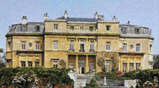
Luton Hoo is an English country house and estate near Luton in Bedfordshire and Harpenden in Hertfordshire. Most of the estate lies within the civil parish of Hyde, Bedfordshire. The Saxon word Hoo means the spur of a hill, and is more commonly associated with East Anglia.
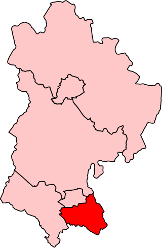
Luton South is a constituency in Bedfordshire represented in the House of Commons of the UK Parliament since 2019 by Rachel Hopkins, a member of the Labour Party.

Caddington is a village and civil parish in the Central Bedfordshire district of Bedfordshire, England. It is south of Luton.

Chalton is a village and civil parish in the Central Bedfordshire district of Bedfordshire, England, immediately north of the Luton/Dunstable conurbation and bounded to the east by the M1 motorway and the Midland Main Line railway line.

Offley is a civil parish in the English county of Hertfordshire, between Hitchin and Luton. The main village is Great Offley, and the parish also contains the nearby hamlets of Little Offley and The Flints. In the south-west of the parish, near Luton, there are the hamlets of Cockernhoe, Mangrove Green and Tea Green, and also the Putteridge Bury estate; these have LU2 postcodes and 01582 telephone numbers.

Chiltern Green railway station was built by the Midland Railway in 1868 on its extension to St. Pancras.
Chiltern Green is a hamlet located in Bedfordshire, England. It is in the civil parish of Hyde.

Clophill is a village and civil parish clustered on the north bank of the River Flit, Bedfordshire, England. It is recorded in the Domesday Book of 1086 as Clopelle. "Clop" likely means 'tree-stump' in Old English. However, it also has cognate terms for clay, with which the soil of mid Bedfordshire is rich.
Luton is a town located in the south of Bedfordshire, England.

Dunstable is a market town and civil parish in Bedfordshire, England, east of the Chiltern Hills, 30 miles north of London. There are several steep chalk escarpments, most noticeable when approaching Dunstable from the north. Dunstable is the fourth largest town in Bedfordshire and along with Houghton Regis forms the westernmost part of the Luton/Dunstable urban area.

Sharpenhoe is a small village in Bedfordshire, England, at the foot of the hills known as the Sharpenhoe Clappers, which are within the Chilterns AONB. Smithcombe, Sharpenhoe and Sundon Hills are a Site of Special Scientific Interest, and most of it is a National Trust property. It is in the civil parish of Streatley.

The Dunstable Branch Lines were railway branch lines that joined the English town of Dunstable to the main lines at Leighton Buzzard and Welwyn. The two lines were under separate ownership and joined just east of the Dunstable North station.
New Mill End is a hamlet located in Bedfordshire, England, close to county border with Hertfordshire. It is in the civil parish of Hyde, Bedfordshire
