Sports and leisure facilities
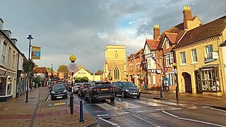
The Greensand Ridge Walk and the Greensand Cycle Way pass through Clophill.
The village has a youth football club called Clophill United FC. The 2023/24 season has nine teams (U6 to U18) playing in the Mid Beds Mini League, Chiltern Junior 7s and Beds Youth Saturday League.
In the summer of 2022, Clophill St Mary's Lower School and Clophill United joined forces to form one club affiliated with the Bedfordshire Football Association. The aim of the merger being to secure football in the village for children from reception to under 18, providing continuity for teams as they develop over the years, especially as they graduate from lower school.

Flitwick is a town and civil parish in Central Bedfordshire, England. It is mentioned in the Domesday Book of 1086 as "a hamlet on the River Flitt". The spelling Flytwyk appears in 1381.

Kempston is a town and civil parish in the Borough of Bedford, Bedfordshire, England, situated around 2 miles (3.2 km) south-west of Bedford town centre. It had a population of 19,330 in the 2011 census, and forms part of the wider Bedford built-up area. The River Great Ouse separates it from the Queen's Park area of Bedford.

Woburn is a town and civil parish in Bedfordshire, England, about 5 miles (8 km) southeast of Milton Keynes and 3 miles (5 km) south of junction 13 of the M1 motorway. At the 2011 census, it had a population of 933.

Old Warden is a village and civil parish in the Central Bedfordshire district of the county of Bedfordshire, England, about 6.5 miles (10 km) south-east of the county town of Bedford.

Everton is a small rural village of about 200 dwellings and civil parish in the Central Bedfordshire district of Bedfordshire, England about 9 miles (14 km) east of the county town of Bedford.

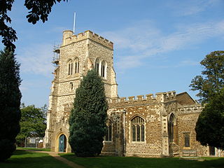
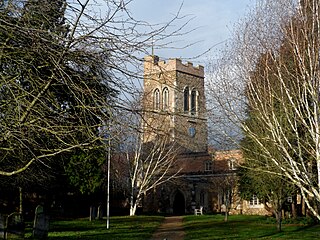
The present St Mary's Church is located in the centre of the small village of Clophill, between Bedford and Luton in the county of Bedfordshire in the South Midlands of England. The new church, built in 1848, replaced the old church by order of the Church Commissioners in 1850. The old church building, formally The Church of St Mary The Virgin and known colloquially as Old St Mary's or The Old Parish Church, is at the edge of the village, and is estimated to be around 650 years old. It sits at the crest of the Greensand Ridge, offering views over the surrounding countryside. Its graveyard is a haven for wild flowers and wildlife. After the church moved to the village centre, incorporating various items from the old church building, the old building was converted for use as a mortuary chapel, but in the 1950s it fell into ruin.
Shefford is a town and civil parish in the Central Bedfordshire district of Bedfordshire, England. At the 2021 census it had a population of 7,311. It lies 10 miles (16 km) south-east of Bedford.

Lidlington is a small village and civil parish in Central Bedfordshire, England surrounded by farmland, in the Marston Vale. The hamlets of Boughton End and Thrupp End are also part of the parish.
Henlow is a village and civil parish in the Central Bedfordshire district of the county of Bedfordshire, England, about 11 miles (18 km) south-east of the county town of Bedford. The name Henlow is believed to derive from the old English henna hlaw, meaning in old English "hill of birds" or “hill frequented by birds”.

Caddington is a village and civil parish in the Central Bedfordshire district of Bedfordshire, England.

Barton-le-Clay is a large village and a civil parish in the Central Bedfordshire district of Bedfordshire, England, bordering Hertfordshire. The village has existed since at least 1066 and is mentioned in the Domesday Book.

Silsoe is a village and civil parish in Bedfordshire, England. The village used to be on the main A6 road but a bypass around the village was opened in 1981 at a cost of £1.6m.

Maulden is a village and civil parish located in the county of Bedfordshire. The village is located 1.5 miles east of Ampthill and about 8 miles (13 km) south of Bedford. It has about 1,250 homes and 3130 residents.

Langford is a village and civil parish in the Central Bedfordshire district of the county of Bedfordshire, England about 10 miles (16 km) south-east of the county town of Bedford. The 2011 census gives the population as 3,091.

Northill is a village and civil parish in the Central Bedfordshire district of the county of Bedfordshire, England about 6.5 miles (10 km) southeast of the county town of Bedford.
Stanford is a hamlet in the civil parish of Southill, in the Central Bedfordshire district, in the ceremonial county of Bedfordshire, England. It is about 8.5 miles (14 km) south-east of the county town of Bedford.
Wixams is a new town and civil parish located in Bedfordshire, England, which has been under construction since early 2007. It is expected to become the third largest settlement in the Borough of Bedford after Bedford itself and Kempston, and one of the largest new settlements founded in England since the British new towns movement of the first twenty five years after World War II.

Husborne Crawley is a small village and civil parish in Bedfordshire, England, located close to Junction 13 of the M1 motorway. The village touches the borders of the Woburn Abbey estate on one side, and the village of Aspley Guise on the other. The meaning of the Husborne element of the towns name is "warrior stream" and the Crawley element means "crow clearing". It appears as Hussheburn Crawele, in 1421.
Southill is a rural village and civil parish in the Central Bedfordshire district of the county of Bedfordshire, England; about 8 miles (13 km) south-east of the county town of Bedford.
"Greensand Cycleway" signs for this route appeared in the first half of 2014. It covers roughly 40 miles (64 km), using minor roads and runs roughly in parallel with its sister walk, the Greensand Ridge Walk. The route traverses Bedfordshire, making brief forays into the neighbouring counties of Cambridgeshire and Buckinghamshire. Its southern endpoint is at Leighton Buzzard and the route runs north-east to Sandy. The waymarker for this route is simply Greensand Cycleway and the depiction of a bicycle on a brown background. There are some smaller, circular waymarkers employed to ensure continuity of the route for cyclists.


