Tingrith

Last updated

Tingrith
St Nicholas, Tingrith , Porch, South Aisle and Nave - geograph.org.uk - 220850.jpg
Church of St Nicholas
Bedfordshire UK location map.svg
Red pog.svg
Tingrith
Location within Bedfordshire
Population153 (2011)
OS grid reference TL006813
Civil parish
  • Tingrith
Unitary authority
Shire county
Ceremonial county
Region
Country England
Sovereign state United Kingdom
Post town MILTON KEYNES
Postcode district MK17
Dialling code 01525
Police Bedfordshire
Fire Bedfordshire and Luton
Ambulance East of England
UK Parliament
List of places
UK
England
Bedfordshire
51°58′48″N0°32′02″W / 51.98°N 0.533889°W / 51.98; -0.533889 Coordinates: 51°58′48″N0°32′02″W / 51.98°N 0.533889°W / 51.98; -0.533889
Church Road, Tingrith Church Road, Tingrith - geograph.org.uk - 220851.jpg
Church Road, Tingrith
A British War Office map from 1940 displaying the area around Tingrith Civil Parish, Central Bedfordshire Area surrounding Tingrith Civil Parish, Central Bedfordshire.png
A British War Office map from 1940 displaying the area around Tingrith Civil Parish, Central Bedfordshire

Tingrith is a small village and civil parish in Bedfordshire, England. It is located adjacent to the M1 motorway near the large village of Toddington. The nearest major town is Luton, located about 10 miles (16 km) to the southeast. The parish church of St Nicholas dates back to the 13th century [1] and has Tingrith's only cemetery. The church can seat up to 200 people. [2]

Contents

Tingrith has a population of 153 people – a ratio of 78:75 males to females, according to the 2011 census. [3]

Tingrith is mentioned in the Domesday Book; the entry states Tingrei: Thorgils from Nigel d'Aubigny

History

In the 1870s, Tingrith was described as:

A parish in Woburn district, Beds; 4 miles E of Woburn, and 4½ SE of Ridgmount r. station. Real property, £1,450. Pop., 226. Houses, 38. The living is a rectory in the diocese of Ely. Value, £240.* Patrons, Misses Trevor. The church is chiefly later English. [4]

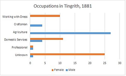
In the past, the most common occupation for males over the age of 20 in Tingrith was agricultural labour; in 1831 70% of males over the age of 20 were working in agriculture. [5] Other popular occupations during this time were: farmers employing labourers, retail, professionals and servants. In 1881 agricultural work was still very popular in the Tingrith area, with 64% of males working in agriculture. [6] Although information for male occupations was well recorded, 50% of female occupations were unknown in 1881. [6] Of the female occupations that were recorded in 1881, the most common were for women to work in the domestic services or offices or working with dress. [6] As 84% of the occupations were labourers or servants in 1831, it can interpreted that Tingrith at this time was a lower class area. Along with this, in 1831 only 11% of the population were employers or professionals. [6]

Occupations in Tingrith, 1881.jpg Occupations in Tingrith, 2011.jpg

As seen from the graphs above, today in Tingrith, the most common occupations for males are leading roles, such as managers, directors or senior officials. This is closely followed by jobs in skilled trade. This is very different to the most common occupation in 1881, which was agriculture; very little of this is seen in Tingrith today. The most common occupation among females is a working professional; this is closely followed by jobs in leading roles, such as managers, directors and senior officials. It is clear that far more women are working today than back in 1881, as far more of their occupations are recorded.

Demography

According to the 2011 census, 71.3% of the population of Tingrith are over the age of 30. [7] The ethnic make up of the area is predominantly white; 89.5% of the population in this area are White (English, Welsh, Scottish or Northern Irish). The rest of the population are White Irish (3.3%), White Other (2.6%), Mixed Ethnic Group- White and Black Caribbean (1.3%), Mixed ethnic group- other (0.7%), Asian/Asian British- Indian (2%) and Black British- Caribbean (0.7%). [8] Tingrith Population Change.jpg

The area had a larger population around the 1870s of approximately 210 residents, the population then dipped to approximately 110 residents just less than 100 years later, around 1960. This then rose steadily to today's population of 153 residents.

Today the percentage of people over the age of 16, with 5 or more GCSE grades A-C is 20%; higher than the national average of 15.2%. [9] Along with this, the percentage of unemployed in Tingrith is only 1.7%, which is lower than the national average of 4.4% [9]

Housing and transport

The number of houses in Tingrith has steadily grown from 1831. In 1831 there were 27 houses in Tingrith but this rose to 46 houses in 1951 and then dropped to 42 houses ten years later, in 1961. [10] Today there are 59 houses in Tingrith civil parish [3] According to the 2011 census, 49.2% of the Tingrith population own their homes outright; this is almost 20 percentage points higher than the national average. [3]

House prices in Tingrith range from approximately £120,000 up to £765,000. [11]

The closest rail stations are Flitwick and Harlington, which are within a 2-mile radius of Tingrith. [12] The closest airports are Cranfield (8 miles) and Luton (16 miles). [12]

Notable residents

Sandra Kynes, the Pagan author, lived in Tingrith during her time in the United Kingdom.[ citation needed ]

Charles Tanqueray, the founder and distiller of Tanqueray Gin in 1830 lived at Tanqueray House. [13]

Related Research Articles

Cratfield Human settlement in England

Cratfield is a village in northern Suffolk, England. "It has a population of 292 according to the 2011 census." Neighbouring villages include Laxfield, Metfield, Cookley, Huntingfield, Heveningham. The nearest town, Halesworth, is approximately 6.7 miles (10.7 km) away. Southwold is a popular, nearby coastal town. The market town of Framlingham is also close by.

Acton Turville Human settlement in England

Acton Turville is a parish in the Cotswold Edge ward within South Gloucestershire, England. It lies 17 miles (27 km) east-northeast of Bristol and 93 miles (150 km) due west of London, with the M4 south of the parish. Acton Turville consists of a cluster of households across 1,009 acres, with a total population of 370 people. Acton Turville is also listed as "Achetone" in the Domesday Book.

Easton, Cambridgeshire Human settlement in England

Easton is a village and civil parish in Cambridgeshire, England. Easton lies approximately 6 miles (10 km) west of Huntingdon, between the villages of Ellington and Spaldwick. Easton is situated within Huntingdonshire which is a non-metropolitan district of Cambridgeshire as well as being a historic county of England. Easton is a hamlet which the Anglo Saxons settled in.

Slawston Human settlement in England

Slawston is a village and civil parish in the Harborough district of Leicestershire, England, north-east of Market Harborough. According to the 2001 census the parish had a population of 143, including Welham and increasing to 191 at the 2011 census. The parish includes the deserted village of Othorpe at grid reference SP770956. Slawston is located roughly 1 km away from Medbourne.

Ashleyhay Human settlement in England

Ashleyhay is a village and civil parish in the Amber Valley district of Derbyshire, England, about five miles north-west of Belper. It is also situated one and three-quarters of a mile south of Wirksworth and eleven miles north of Derby city centre. According to the 2001 census it had a population of 105, increasing to 118 at the 2011 Census.

Darenth Human settlement in England

Darenth is a village and civil parish in the Borough of Dartford, Kent, England. It is located 3.4 miles south east of Dartford and 4.6 miles north east of Swanley.

Bransford Human settlement in England

Bransford is a village and civil parish in the Malvern Hills district of the county of Worcestershire, England. It is situated close to the River Teme and the village of Leigh. It is on the primary route between Worcester and Hereford, the A4103 that runs through the centre of the village. According to the 2011 census, Bransford has a population of 389. The parish shares its parish council with Leigh.

Peover Inferior Human settlement in England

Peover Inferior is a civil parish in the Borough of Cheshire East and the ceremonial county of Cheshire, England. The village is known for its picturesque surrounding countryside and surprisingly convenient location. The name Peover is pronounced 'Peever' and derives from the Anglo-Saxon 'Peeffer' meaning 'a bright river', this 'bright river' being the River Peover which runs through the parish. The village and its neighbour Peover Superior lie on the river Peover, 'Inferior' here meaning downstream. The parish is situated on the B5081 roughly 25 km south south west of Manchester between Knutsford and Holmes Chapel and within five miles of junction 19 on the M6. Together with Nether Peover, it forms part of the village of Lower Peover, Lower Peover being the parish council. Peover Inferior is in Cheshire East, however Nether Peover is in Cheshire West, this often causes complications for the Lower Peover parish council. According to the 2011 census, it had a population of 220.

Newborough, Cambridgeshire Human settlement in England

Newborough is a village and a civil parish in the Peterborough district, in the ceremonial county of Cambridgeshire, England. Newborough is situated 7.62 km (4.74 mi) north of Peterborough. Newborough has a population of 1,670 according to the 2011 census

Clopton, Suffolk Human settlement in England

Clopton is a village and civil parish in Suffolk. It is located between Ipswich and Debenham two kilometres north of Grundisburgh on the River Lark. The village is no larger than a series of houses either side of the B1078, surrounded by farm land. The village itself has no clear centre; houses and other buildings are concentrated around the four manors of Kingshall, Brendhall, Rousehall and Wascolies, all of which are mentioned in the Domesday Book of 1086.

Fakenham Magna Human settlement in England

Fakenham Magna is a village and civil parish in the West Suffolk district of Suffolk in eastern England. The meaning of the word 'Fakenham' can be split into two: 'Faken' and 'ham', both of which derive from Old English. The former refers to somebody by the name of 'Facca', with the latter meaning 'a village / a homestead', making the direct translation 'Facca's homestead'. 'Magna' translates from Latin as 'great', hence the alternative name of the village of 'Great Fakenham'. During World War Two, however, the village was referred to as 'Little Fakenham', which was used to avoid confusion with the larger civil parish of Fakenham in Norfolk.

Stansfield Human settlement in England

Stansfield is a village and civil parish in the West Suffolk district of Suffolk in eastern England. Located seven miles south-west of Bury St Edmunds, in 2011 its population was 221. The village has an Anglican church dedicated to All Saints. In 1870, John Marius Wilson's Imperial Gazetteer of England and Wales described Stansfield as

Ousden Human settlement in England

Ousden is a village and civil parish in the West Suffolk district of Suffolk in eastern England. It is located around six miles west of Bury St Edmunds and 72 miles north of London, and as of 2011, its population is 266. The village has an Anglican church of St Peter's and a chapel in the cemetery dedicated to St Barnabas.

Tugby and Keythorpe Human settlement in England

Tugby and Keythorpe is a civil parish comprising the village of Tugby and land surrounding Keythorpe Hall, Hall Farm and Lodge Farm in Leicestershire, England, part of the Harborough district. The Parish covers around 2,200 acres, situated 7 miles west of Uppingham, and 12 miles east of Leicester. According to the 2011 census the population of the parish was 330. The Anglican parish register for the parish dates back to 1568. The boundaries of the parish have not changed throughout the years, meaning that the parish's size remains the same as it did in 1568.

North Lopham Human settlement in England

North Lopham is a village and civil parish in the English county of Norfolk.

Lamarsh Human settlement in England

Lamarsh is a village and a civil parish in the Braintree District, in the county of Essex, England. It is near the large village of Bures and the village of Alphamstone. The village is west of the River Stour. It has a pub, a village hall and a church called The Friends of Holy Innocents Church. The civil parish's name, Lamarsh, comes from the phrase "Loamy marsh". This is derived from the Old English terms lām and mersc, which translate into loam or clay and a marsh respectively.

Swilland Human settlement in England

Swilland is a village and civil parish, in the East Suffolk district, in the English county of Suffolk. It is north of the large town of Ipswich. Swilland has a church called St Mary's Church and a pub called The Moon & Mushroom Inn which has been awarded Suffolk Pub of The Year on two occasions by the Evening Star. Swilland shares a parish council with Witnesham called "Swilland and Witnesham Grouped Parish Council".

Huntingfield, Suffolk Human settlement in England

Huntingfield is a village near the B1117 road, in the East Suffolk district, in the county of Suffolk, England. The village is close to the source of the River Blyth and the parish is 12 miles from the seaside town of Southwold. Nearby settlements include the town of Halesworth and the villages of Walpole, Heveningham, Cookley and Laxfield.

Stapleford, Hertfordshire Human settlement in England

Stapleford is a village and civil parish of 134 acres (54 ha) on the A119 road, in the East Hertfordshire district, in the county of Hertfordshire, England. Stapleford is located between Waterford and Watton-at-Stone in the Beane valley; the little river was forded at this point, giving rise to the village. Stapleford's parish church is St Mary's Church. Beane is a hamlet of Stapleford.

Standon, Staffordshire Human settlement in England

Standon is a village and civil parish in the Stafford district, in the county of Staffordshire, England. Standon has a church called Church of All Saints and one school called All Saints C of E First School. In 2001 the population of the civil parish of Standon was 823, and in the 2011 census it had a population of 879.

References

  1. "St Nicholas, Tingrith". A Church near you. Archbishop's Council. Retrieved 10 March 2016.
  2. Hinson. "GENUKI: Tingrith, Bedfordshire". GEN UKI: UK and Ireland Genealogy. GEN UKI. Retrieved 10 March 2016.
  3. 1 2 3 "Tingrith: Key Figures for 2011 Census: Key Statistics". Neighbourhood Statistics. Office for National Statistics. Retrieved 28 January 2016.
  4. Wilson, John Marius (1870–72). Imperial Gazetteer of England and Wales. Edinburgh: A. Fullerton & Co.
  5. Gatley, David Allan. "Tingrith, 1831 Occupational Categories". A Vision of Britain Through Time. GB Historical GIS/ University of Portsmouth. Retrieved 14 March 2016.
  6. 1 2 3 4 "Tingrith 1881 Occupational Orders". A Vision of Britain Through Time. GB Historical GIS/ University of Portsmouth. Retrieved 14 March 2016.
  7. "Tingrith- Age Structure, 2011". Neighbourhood Statistics. Office for National Statistics. Retrieved 15 March 2016.
  8. "Tingrith- Ethnic Group, 2011". Neighbourhood Statistics. Office for National Statistics. Retrieved 15 March 2016.
  9. 1 2 "Key Figures for 2011 Census:Key statistics". Neighbourhood Statistics. Office for National Statistics. Retrieved 10 March 2016.
  10. "Tingrith, Housing- Total Houses". A Vision of Britain Through Time. GB Historical GIS/ University of Portsmouth. Retrieved 14 March 2016.
  11. "UK's number one property website for properties for sale and to rent". www.rightmove.co.uk. Right Move. Retrieved 19 April 2016.
  12. 1 2 "Tingrith, Bedfordshire – Hotels, Transport and Local Information". www.scoutlocal.co.uk. Scout Local. Retrieved 19 April 2016.
  13. "Freeth Notes : Thomas Tanqueray 1724". freethnotes.net. Retrieved 9 October 2016.

Commons-logo.svg Media related to Tingrith at Wikimedia Commons