
Woburn is a town and civil parish in Bedfordshire, England, about 5 miles (8 km) southeast of Milton Keynes and 3 miles (5 km) south of junction 13 of the M1 motorway. At the 2011 census, it had a population of 933.

Ellesborough is a village and civil parish in Buckinghamshire, England. The village is at the foot of the Chiltern Hills just to the south of the Vale of Aylesbury, two miles from Wendover and five miles from Aylesbury. It lies between Wendover and the village of Little Kimble.
Bromham is a village and civil parish in the Borough of Bedford in Bedfordshire, England, situated around 3 miles (4.8 km) west of Bedford town centre.

Haynes is a village and civil parish in Bedfordshire, England, about seven miles (11 km) south of Bedford. It includes the small hamlet of Haynes Church End. It used to be known as Hawnes. North from Haynes is a hamlet named Silver End, then further up is Herrings Green, Cotton End and Shortstown. There is a pub, "The Greyhound", a shop, a post office, a village hall and a Lower School.
Barrowby is a village and civil parish in the South Kesteven district of Lincolnshire, England. It is 2 miles (3.2 km) west of Grantham. It overlooks the Vale of Belvoir and has a Grade I listed parish church. The hamlet of Casthorpe is part of the parish. The 2001 Census listed 795 households and a population of 1,996, which fell to 840 households with 1,952 inhabitants at the 2011 census. It was estimated at 1,986 in 2019.
Ridgmont is a small village and civil parish in Bedfordshire, England. It is located beside junction 13 of the M1 motorway, and close to Milton Keynes and Woburn Abbey. The 2001 census states the total population to be 418, reducing to 411 at the 2011 Census.

Bletsoe is a village and civil parish in Bedfordshire, England. It is on the A6, and about eight miles north of Bedford. The village has a small park, the former site of Bletsoe Castle and a church. Nearby places are Sharnbrook, Milton Ernest, Riseley, Thurleigh, Odell, Souldrop, and Swineshead. The nearest town to Bletsoe is Bedford.

Felmersham is a small village and civil parish in the Borough of Bedford in Bedfordshire, England, on the River Great Ouse, about 7 miles (11 km) north west of Bedford. As a civil parish, it includes the hamlet of Radwell, and is sometimes known as Felmersham with Radwell, and has a population of about 800, and is circumscribed by the Great Ouse on the north, east and south. Other nearby places are Sharnbrook, Odell, Pavenham and Milton Ernest. Felmersham with Radwell was recorded in the Domesday Book of 1086 as a parish within the Hundred of Willey. John de Burnham, later Lord High Treasurer of Ireland, was parish priest here in the 1330s.

Almeley is a village and civil parish in Herefordshire, England. The civil parish includes the hamlets of Almeley Wooton, Woonton and Upcott. The 2011 Census recorded the parish's population as 601.

Boughton Aluph is a village and civil parish in the Borough of Ashford in Kent, England, and is about 5 miles (8 km) north of Ashford on the A251 road. There are two villages within the parish: Boughton Aluph itself, and Boughton Lees. Boughton Corner is a small hamlet within the parish, further east on the A28 road.

Swineshead is a village and civil parish in the Borough of Bedford in the county of Bedfordshire, England.

Roughton is a village and civil parish in the East Lindsey district of Lincolnshire, England. The parish population was 644 in 2011.

Cople is a village and civil parish in the English county of Bedfordshire. The name Cople is derived from the phrase Cock Pool, a place where chickens were kept, that was mentioned in the Domesday Book.

Elvaston is a small village and civil parish in Derbyshire, England. The parish also includes two hamlets, Ambaston and Thulston, and a modern housing estate, Boulton Moor. The population of the civil parish taken at the 2011 Census was 1,801.

Podington is a village and civil parish in Bedfordshire, England, United Kingdom. The village is within the electoral ward of Harrold in the Borough of Bedford. Podington lies around 16 km (9.9 mi) northwest of Bedford and is about 2 km (1.2 mi) east of the county border with Northamptonshire.

Houghton Conquest is a village and civil parish located in the Central Bedfordshire district of Bedfordshire, England. The parish also includes the hamlet of How End.
Foston and Scropton is a civil parish in the Dove valley in South Derbyshire. It includes the village of Scropton and hamlet of Foston. The population of the civil parish at the 2001 Census was 728 increasing to 854 at the 2011 Census.

Gravenhurst is a civil parish located in the Central Bedfordshire district of Bedfordshire, England.

Thurleigh is a village and civil parish in the Borough of Bedford, north Bedfordshire, England, situated around 5 miles (8.0 km) north of Bedford town centre.

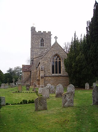
Little Staughton is a small village and civil parish located in the north of Bedfordshire. The parish church, All Saints, is set apart from the present village – the previous village having been abandoned following an outbreak of the Bubonic plague.

