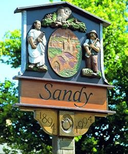
Sandy is a town and civil parish in Central Bedfordshire, England. It lies 8 miles (13 km) to the east of Bedford, 18 miles (29 km) to the south west of Cambridge and 43 miles (69 km) north of Central London. It had a population of 12,171 at the 2021 census.

Leighton Buzzard is a market town in Bedfordshire, England, in the southwest of the county and close to the Buckinghamshire border. It lies between Aylesbury, Tring, Luton/Dunstable and Milton Keynes, near the Chiltern Hills.

Linslade is an area in the civil parish of Leighton-Linslade, in the Central Bedfordshire unitary authority area of Bedfordshire, England. The original village was at Old Linslade on the banks of the River Ouzel. A new settlement called Linslade grew up a mile to the south of Old Linslade in the 19th century, particularly following the opening of Leighton Buzzard railway station there in 1838. Linslade now forms part of the urban area of Leighton Buzzard.

Campton is a village and former civil parish, now in the parish of Campton and Chicksands, in the Central Bedfordshire district of Bedfordshire, England. It is about 9 miles (14 km) south of Bedford, and is about 9 miles (14 km) north-west from Letchworth and sits on a tributary of the River Ivel. It is just to the west of Shefford. The 13th century Church of All Saints is in the centre of the village. In 1961 the parish had a population of 358.

Haynes is a village and civil parish in Bedfordshire, England, about seven miles (11 km) south of Bedford. It includes the small hamlet of Haynes Church End. It used to be known as Hawnes. North from Haynes is a hamlet named Silver End, then further up is Herrings Green, Cotton End and Shortstown. There is a pub, "The Greyhound", a shop, a post office, a village hall and a Lower School.

Stotfold is a town and civil parish in the Central Bedfordshire district of Bedfordshire, England. The town covers 2,207 acres (8.93 km2) and the River Ivel passes through the town. The population of the parish at the 2021 census was 9,014. The wider built-up area, which the Office for National Statistics defines to additionally include the adjoining Fairfield Park development, had a population of 12,310 at the 2021 census. For the purposes of postal addresses, Stotfold comes under the post town of Hitchin; it was therefore in the postal county of Hertfordshire despite actually being in Bedfordshire.
Henlow is a village and civil parish in the Central Bedfordshire district of the county of Bedfordshire, England, about 11 miles (18 km) south-east of the county town of Bedford. The name Henlow is believed to derive from the old English henna hlaw, meaning in old English "hill of birds" or “hill frequented by birds”.

Shillington is a village and civil parish in Bedfordshire, England. In the south of the parish the hamlet of Pegsdon includes the Pegsdon hills nature reserve and is a salient of the county into Hertfordshire. Since 1985 its administration has included the village of Higham Gobion, south-west on the minor road leading to the main north–south road in the district, the A6. It has a population of 1,831 and is centred midway between stopping services railway stations on the Midland Main Line and East Coast Main Line 6 miles (9.7 km) away. Farmland and hedgerows forms 95% of the land use and to the south and north of the boundaries is intermittent woodland.

Astwick is a hamlet and civil parish in the Central Bedfordshire district of the county of Bedfordshire, England. It lies 12+1⁄2 miles (20 km) south-east of the county town of Bedford. Its population is included within Stotfold civil parish.

Barton-le-Clay is a large village and a civil parish in the Central Bedfordshire district of Bedfordshire, England, bordering Hertfordshire. The village has existed since at least 1066 and is mentioned in the Domesday Book.

Chicksands is a village and former civil parish, now in the parish of Campton and Chicksands in the Central Bedfordshire district of Bedfordshire, England. The village is on the River Flit and close to its parish village of Campton and the town of Shefford.

Northill is a village and civil parish in the Central Bedfordshire district of the county of Bedfordshire, England about 6.5 miles (10 km) southeast of the county town of Bedford.
Stanford is a hamlet in the civil parish of Southill, in the Central Bedfordshire district, in the ceremonial county of Bedfordshire, England. It is about 8.5 miles (14 km) south-east of the county town of Bedford.

Clifton is a village and civil parish in the English county of Bedfordshire. The original hundred of Clifton is named after it.

Clophill is a village and civil parish clustered on the north bank of the River Flit, Bedfordshire, England. It is recorded in the Domesday Book of 1086 as Clopelle. "Clop" likely means 'tree-stump' in Old English. However, it also has cognate terms for clay, with which the soil of mid Bedfordshire is rich.

Houghton Conquest is a village and civil parish located in the Central Bedfordshire district of Bedfordshire, England. The parish also includes the hamlet of How End.
Southill is a rural village and civil parish in the Central Bedfordshire district of the county of Bedfordshire, England; about 8 miles (13 km) south-east of the county town of Bedford.

Stondon is a civil parish located in the Central Bedfordshire district of Bedfordshire, England. The parish includes the settlements of Lower Stondon and Upper Stondon.

Hulcote is a village and a former civil parish, now in the parish of Hulcote and Salford, in the Central Bedfordshire district of the ceremonial county of Bedfordshire, England. In 1931 the parish had a population of 39.

Upper Gravenhurst is a village and former civil parish, now in the parish of Gravenhurst, in the Central Bedfordshire district of the ceremonial county of Bedfordshire, England. In 1881 the parish had a population of 354. On 24 March 1888 the parish was abolished and merged with Lower Gravenhurst to form "Gravenhurst".