St Germans, Cornwall

Last updated

St Germans
St Germans Church and arched entrance - geograph.org.uk - 1024975.jpg
Cornwall UK mainland location map.svg
Red pog.svg
St Germans
Location within Cornwall
Population1,453 (2011 Census including Bake and Budge's Shop)
OS grid reference SX359578
Civil parish
  • St Germans
Unitary authority
Ceremonial county
Region
Country England
Sovereign state United Kingdom
Post town SALTASH
Postcode district PL12
Dialling code 01503
Police Devon and Cornwall
Fire Cornwall
Ambulance South Western
UK Parliament
List of places
UK
England
Cornwall
50°23′46″N4°18′36″W / 50.396°N 4.310°W / 50.396; -4.310

St Germans (Cornish : Lannaled) [1] is a village and civil parish in east Cornwall, England, United Kingdom. It stands on the River Tiddy, just upstream of where that river joins the River Lynher; the water way from St Germans to the Hamoaze is also known as St Germans River.

Contents

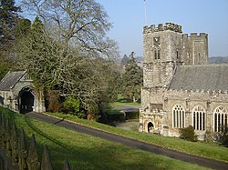
It takes its name from the St. German's Priory, generally associated with St Germanus, although the church may have been associated initially with a local saint, who was gradually replaced by the 14th century. [2] This Norman church is adjacent to the Port Eliot estate of the present Earl of St Germans.

The other villages in the historic parish were Tideford, Hessenford, Narkurs, Polbathic, and Bethany, but new ecclesiastical parishes were established in 1834 (St Anne's Church, Hessenford) and 1852 (Tideford). In 1997 part of the St Germans parish was made into Deviock parish. The area of the civil parish is 10,151 acres (4,108 ha), and it has a population of 1,427, [3] increasing to 1,453 at the 2011 census. [4] An electoral ward with the name St Germans also exists. The population at the 2011 census was 4,301. [5]

Parliamentary borough

The village was one of the rotten boroughs, electing two members to the unreformed House of Commons until the Reform Act 1832. As in many of the Cornish rotten boroughs, the franchise in St Germans was restricted to a tiny number of "freemen", rather than to all residents, but even they were not numerous—by the time of the Reform Bill, the male population of the borough was only 247. However, the previous census had shown that the whole parish (of which the borough made up only a fraction) had a population of 2,404, and the initial proposal was that St Germans should lose only one of its two MPs; but the Whig government subsequently decided that the availability of sufficient population in a surrounding parish should not save a borough from disfranchisement unless a substantial part of that population was already within the borough boundaries, amending the bill's schedules so as to extinguish both of the St Germans MPs. The Tory opposition attacked the decision as politically motivated (St Germans was a Tory borough), and the vote in the Commons was one of the narrowest in the entire Reform Bill debates.

The seal of the borough of St Germans was St German seated on a throne, with the legend "S. Prepositure Sci Germani in laya". [6]

Landmarks

St Germans war memorial St Germans war memorial.jpg
St Germans war memorial

There is a stone cross at Carracawn dedicated to the members of the parish who died in the First and Second World Wars . [7] [8]

Church history

See of St Germans

St Germans was originally the seat of the Bishop of Cornwall before the see was combined with that of Crediton in 1042. Today the Bishop of Truro's assistant (suffragan) bishop is known as the Bishop of St Germans in acknowledgement of this, although he has no specific links with the village. The first of these bishops was appointed in 1905. Under its Latin name of Sanctus Germanus, the see is included in the Catholic Church's list of titular sees. The adjectival form of the name of the see is Cornubiensis, meaning "Cornish" or "of Cornwall". [9]

St Germans Priory Church

John of Cornwall

John of Cornwall, in Latin Johannes Cornubiensis or Johannes de Sancto Germano, was a Christian scholar and teacher, who was living in Paris about 1176. Little is known of his life. From his names, it is surmised that he was a native of St Germans.

Almshouses

Sir William Moyle's Almshouses The Sir William Moyle's Almshouses at St Germans - geograph.org.uk - 804061.jpg
Sir William Moyle's Almshouses

Sir William Moyle's Almshouses , also known as the Galleries, date from 1583. They are unusual in that they consisted of six one-room apartments on the ground floor and a further six on the first floor. The upper rooms open onto a gallery along the front of the range, which is reached by stairs at either end. The almshouses were converted into four separate dwellings in the 20th century; it is a Grade II* listed building. [10]

Fishing quay, railway station and viaduct

It was originally a busy fishing village in the 19th century. The St Germans Quay was busy in the last century with cargoes of timber, coal and limestone and materials for the building of the railway that was to bring about the demise of river trade . Until the last war the trade in roadstone continued. Now St Germans Quay is home to the village sailing club: the Quay Sailing Club (QSC). The sailing club is now well established and plays a part in the life of the village.

St Germans railway station was opened on 4 May 1859 at the west end of St Germans viaduct, 106 feet above the quay. It is notable for having the best-preserved Cornwall Railway station buildings.

May Fair

There are references in St Germans to a fair in 1284, as well as a second fair on Lammas Day. A rental of Landrake Manor made in 1652 says 'there was a Fayre keept yeerely within the Towne of St Germans upon the Last Tursday in Maye' but notes that the fair has decayed and ended under Cromwell's government. [11] However the fair was revived shortly after the Restoration, possibly due to the similarly timed Oak Apple Day to celebrate the Restoration, and there are multiple references to it from then on. Indeed, it is listed annually in local newspapers until the late 1950s, with the date of the fair held on the nearest possible day to 28 May. [11]

Robert Hunt in Popular Romances of the West of England describes a two-day festival, that took place on the 28th and 29 May. On 28 May, a 'mock mayor' was chosen 'with many formalities, remarkable only for their rude and rough nature', and cattle were brought into the village for the fair. On the 29th the mock mayor, who had been 'supping too freely of the fair ale', was pulled around on a cart to claim his pretend jurisdiction. On this day, anyone entering the village without the leaf or branch of an oak leaf in his hat was thrown in the trough of water fed by a stream on Nut Tree Hill. [12]

On 27 May 2012, the fair was revived. A new "mock mayor" was elected, and a symbolic May tree was paraded through the village. This is a wooden, decorated garland that is symbolic of a walnut nut tree that once stood on the green at the top of present-day Old Quay lane. It was felled between 1865 and 1870, and it was rumoured the wood was used to build cabinets in Port Eliot. Recently a small walnut wood cabinet was re-discovered in church storage and shown to the community during the 2018 May Tree Fair.

Cricket

In the late 19th Century the Earl of St Germans had a cricket ground purposely built about a mile West of St Germans along the B3249. The sloping land was excavated and tree trunks were laid as a base before being covered with top soil to give a flat playing surfaces thus making it one of the first purpose built cricket grounds in the county. St Germans Cricket Club played on the ground until folding in the early 1970s. From 1975 the ground has been the home ground of Tideford Cricket Club who re-located from a site they had been using near Trerulefoot. The views from the ground stretch out to the East as far as Maker Church (7 miles away) and several miles to the South across the valley to the Plymouth – Penzance railway line. To the North the ground is bordered by woods. Whilst the ground is very picturesque the facilities are basic with no mains electricity available (quoted £15K for installation in the 1990s). Tideford Cricket Club runs 2 adult teams (Cornwall Cricket League) and several junior age group teams (West Devon Youth League).

Cornish wrestling

Cornish wrestling tournaments, for prizes, have been held in St Germans. [13]

Twinning

St Germans is twinned with Plouguerneau (Plougerne) in Brittany, France. [14]

Notable people

Related Research Articles

<span class="mw-page-title-main">Penzance</span> Town in Cornwall, England

Penzance is a town, civil parish and port in the Penwith district of Cornwall, England, United Kingdom. It is the most westerly major town in Cornwall and is about 64 miles (103 km) west-southwest of Plymouth and 255 miles (410 km) west-southwest of London. Situated in the shelter of Mount's Bay, the town faces south-east onto the English Channel, is bordered to the west by the fishing port of Newlyn, to the north by the civil parish of Madron and to the east by the civil parish of Ludgvan. The civil parish includes the town of Newlyn and the villages of Mousehole, Paul, Gulval, and Heamoor. Granted various royal charters from 1512 onwards and incorporated on 9 May 1614, it has a population of 21,200.

<span class="mw-page-title-main">Port Eliot</span>

Port Eliot in the parish of St Germans, Cornwall, England, United Kingdom, is the ancestral seat of the Eliot family, whose present head is Albert Eliot, 11th Earl of St Germans.

<span class="mw-page-title-main">Mevagissey</span> Human settlement in England

Mevagissey is a village, fishing port and civil parish in Cornwall, England, United Kingdom. The village is situated approximately five miles (8 km) south of St Austell. The parish population at the 2011 census was 2,015, whereas the ward population at the same census was 4,354.

<span class="mw-page-title-main">St German's Priory</span> Church in St Germans, Cornwall

St Germans Priory is a large Norman church in the village of St Germans in south-east Cornwall, England, UK.

<span class="mw-page-title-main">St Just in Penwith</span> Town in Cornwall, England

St Just, known as St Just in Penwith, is a town and civil parish in the Penwith district of Cornwall, England, United Kingdom. It lies along the B3306 road which connects St Ives to the A30 road. The parish encompasses the town of St Just and the nearby settlements of Trewellard, Pendeen and Kelynack: it is bounded by the parishes of Morvah to the north-east, Sancreed and Madron to the east, St Buryan and Sennen to the south and by the sea in the west. The parish consists of 7,622 acres (3,085 ha) of land, 12 acres (4.9 ha) of water and 117 acres (47.3 ha) of foreshore. The town of St Just is the most westerly town in mainland Britain and is situated approximately 8 miles (13 km) west of Penzance along the A3071. St Just parish, which includes Pendeen and the surrounding area, has a population of 4,637. An electoral ward of the same name also exists: the population of this ward at the same census was 4,812.

<span class="mw-page-title-main">Chacewater</span> Village and civil parish in Cornwall, England, UK

Chacewater is a village and civil parish in Cornwall, England, UK. It is situated approximately 3 miles (4.8 km) east of Redruth. The hamlets of Carnhot, Cox Hill, Creegbrawse, Hale Mills, Jolly's Bottom, Salem, Saveock, Scorrier, Todpool, Twelveheads and Wheal Busy are in the parish. The electoral ward is called Chacewater & Kenwyn. At the 2011 census a population of 3,870 was quoted.

<span class="mw-page-title-main">Paul, Cornwall</span> Village in southwest Cornwall, England

Paul is a village in Cornwall, England, United Kingdom. It is in the civil parish of Penzance. The village is two miles (3 km) south of Penzance and one mile (1.6 km) south of Newlyn.

<span class="mw-page-title-main">Grampound</span> Human settlement in England

Grampound is a village and former civil parish, now in the parish of Grampound with Creed, in the Cornwall district, in the ceremonial county of Cornwall, England. It is at an ancient crossing point of the River Fal and today is on the A390 road six miles (10 km) west of St Austell and eight miles (13 km) east of Truro. In 1961 the parish had a population of 412.

<span class="mw-page-title-main">Calstock</span> Village and civil parish in England

Calstock is a civil parish and a large village in south east Cornwall, England, United Kingdom, on the border with Devon. The village is situated on the River Tamar 6 miles (9.7 km) south west of Tavistock and 10 miles (16 km) north of Plymouth.

<span class="mw-page-title-main">St Minver</span> Human settlement in England

St Minver is the name of an ecclesiastical parish, a civil parish and a village in north Cornwall, England, United Kingdom.

<span class="mw-page-title-main">St Stephen-in-Brannel</span> Human settlement in England

St Stephen-in-Brannel is a civil parish and village in mid Cornwall, England. The village is four miles (6.5 km) west of St Austell on the southern edge of Cornwall's china clay district. The parish also contains the villages of Foxhole, Nanpean, Treviscoe and Whitemoor, and the hamlets of Carpalla, Coombe, Currian Vale, High Street, Hornick, Lanjeth, Stepaside and Terras. The population of the civil parish at the 2011 census was 7,119. An electoral ward also exists, bearing the name St. Stephen. The population at the same census was 4,772 only.

<span class="mw-page-title-main">Lelant</span> Village in England

Lelant or Uny Lelant is a village in the civil parish of St Ives in, west Cornwall, England, UK. It is on the west side of the Hayle Estuary, about 2+12 miles (4.0 km) southeast of St Ives and one mile (1.6 km) west of Hayle. The village is part of the Lelant and Carbis Bay ward on Cornwall Council, and also the St Ives Parliamentary constituency. The birth, marriage, and death registration district is Penzance. Its population at the 2011 census was 3,892 The South West Coast Path, which follows the coast of south west England from Somerset to Dorset passes through Lelant, along the estuary and above Porth Kidney Sands.

<span class="mw-page-title-main">Gunnislake</span> Human settlement in England

Gunnislake is a large village in east Cornwall, England, United Kingdom. It is situated in the Tamar Valley approximately ten miles (16 km) north of Plymouth The first woman cabinet minister in the British Empire, Mary Ellen Smith, was born here in 1863.

<span class="mw-page-title-main">Hessenford</span> Human settlement in England

Hessenford is a small village in south-east Cornwall, United Kingdom, four miles west of St Germans on the A387 Polbathic to Polperro road. The village had a population of 170 at the 2001 census. It is in the civil parish of Deviock. The river Seaton runs through the village and a mill was recorded here in 1286; the last mill closing in the mid-20th century.

<span class="mw-page-title-main">Tideford</span> Human settlement in England

Tideford is a small village in east Cornwall, England, United Kingdom. It is twinned with Plouguerneau in Brittany, France.

St Germans was a rotten borough in Cornwall which returned two Members of Parliament to the House of Commons in the English and later British Parliament from 1562 to 1832, when it was abolished by the Great Reform Act.

<span class="mw-page-title-main">Rame, Maker-with-Rame</span> Human settlement in England

Rame is a village and former civil parish, now in the parish of Maker-with-Rame, in the Cornwall district, in the ceremonial county of Cornwall, England. It is situated on the Rame Peninsula, between Rame Head and the village of Cawsand, in South East Cornwall. In 1931 the parish had a population of 501. On 1 April 1950 the parish was abolished and merged with Maker to form "Maker with Rame". Rame means the high protruding cliff, or possibly, the ram's head.

<span class="mw-page-title-main">River Tiddy</span> River in south-east Cornwall, England

The River Tiddy is a small river in south-east Cornwall, England, United Kingdom. It is the main tributary of the River Lynher. The Tiddy rises near Pensilva and flows south east past the village of Tideford until it joins the Lynher just after passing St Germans. The name of Tideford derives from its location on the river, literally meaning "Ford on the River Tiddy".

The Bishop of St Germans is an episcopal title which was used by Anglo Saxon Bishops of Cornwall and currently in use in the Church of England and in the Roman Catholic Church.

<span class="mw-page-title-main">Deviock</span>

Deviock is a coastal civil parish in south-east Cornwall, England, United Kingdom. It is situated approximately three miles (5 km) west of St Germans and straddles the valley of the River Seaton. The parish includes the settlements of Hessenford, Seaton and Downderry and the population in the 2001 census was 1341, increasing to 1,420 at the 2011 census. The parish occupies an area of 2,108 hectares.

References

  1. Place-names in the Standard Written Form (SWF) Archived 15 May 2013 at the Wayback Machine  : List of place-names agreed by the MAGA Signage Panel Archived 15 May 2013 at the Wayback Machine . Cornish Language Partnership.
  2. W. M. M. Picken
  3. Office for National Statistics Census 2001: Parish Headcounts: Caradon Archived 23 December 2015 at the Wayback Machine Retrieved 30 January 2010
  4. "Parish population 2011 census". Archived from the original on 9 February 2015. Retrieved 9 February 2015.
  5. "Ward population 2011" . Retrieved 13 February 2015.
  6. Pascoe, W. H. (1979). A Cornish Armory. Padstow, Cornwall: Lodenek Press. p. 134. ISBN   0-902899-76-7.
  7. Langdon, A. G. (1896) Old Cornish Crosses. Truro: Joseph Pollard; p. 201
  8. Imperial War Museum, St Germans, 9317 in War Memorials Register
  9. Annuario Pontificio 2013 (Libreria Editrice Vaticana, 2013, ISBN   978-88-209-9070-1), p. 963
  10. Stuff, Good. "Sir William Moyle's Almshouses – St Germans – Cornwall – England – British Listed Buildings".
  11. 1 2 Manley, Helen (2019). The revival of folk tradition: St Germans May Tree fair Paperback. Cornwall: Cat on The Stairs. ISBN   978-1096421955.
  12. "Popular romances of the West of England; or, the Drolls, traditions, and superstitions of Old Cornwall". Notes and Queries. s6-III (73): 420. 21 May 1881. doi:10.1093/nq/s6-iii.73.420a. ISSN   1471-6941.
  13. West Briton and Cornwall Advertiser, 2 August 1973.
  14. "Twinning Trip Cancelled". Western Morning News . 6 April 2001.