
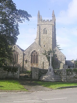
St Germans is a village and civil parish in east Cornwall, England, United Kingdom. It stands on the River Tiddy, just upstream of where that river joins the River Lynher; the water way from St Germans to the Hamoaze is also known as St Germans River.

St Just, also known as St Just in Penwith, is a town and civil parish in the Penwith district of Cornwall, England, United Kingdom. It lies along the B3306 road which connects St Ives to the A30 road. The parish encompasses the town of St Just and the nearby settlements of Trewellard, Pendeen and Kelynack: it is bounded by the parishes of Morvah to the north-east, Sancreed and Madron to the east, St Buryan and Sennen to the south and by the sea in the west. The parish consists of 7,622 acres (3,085 ha) of land, 12 acres (4.9 ha) of water and 117 acres (47.3 ha) of foreshore. The town of St Just is the most westerly town in mainland Britain and is situated approximately 8 miles (13 km) west of Penzance along the A3071. St Just parish, which includes Pendeen and the surrounding area, has a population of 4,637. An electoral ward of the same name also exists: the population of this ward at the same census was 4,812.

The Diocese of Truro is a Church of England diocese in the Province of Canterbury which covers Cornwall, the Isles of Scilly and a small part of Devon. The bishop's seat is at Truro Cathedral.
Stithians, also known as St Stythians, is a village and civil parish in Cornwall, England, United Kingdom. It lies in the middle of the triangle bounded by Redruth, Helston and Falmouth. Its population (2001) is 2,004, increasing to 2,101 at the 2011 census An electoral ward in the same name also exists but stretches north to St Day. The population here also at the 2011 census was 5,023.
Luxulyan, also spelt Luxullian or Luxulian, is a village and civil parish in mid Cornwall, England, United Kingdom. The village lies four miles (6.5 km) northeast of St Austell and six miles (10 km) south of Bodmin. The population of the parish was 1,371 in the 2001 census. This had risen to 1,381 at the 2011 census.

Ludgvan is a civil parish and village in Cornwall, England, UK, 2+1⁄2 miles (4 km) northeast of Penzance. Ludgvan village is split between Churchtown, on the hill, and Lower Quarter to the east, adjoining Crowlas. For the purposes of local government, Ludgvan elects a parish council every four years; the town elects a member to Cornwall Council under the Ludgvan division.

St Issey is a civil parish and village in Cornwall, England, United Kingdom which lies approximately two miles (3 km) south of Padstow. The parish covers an area of approximately 4,500 acres (18 km2). At the 2011 census the parish population was 940. An electoral ward with the name of St Issey also existed before being replaced by St Issey and St Tudy in 2013. Its population at the same census was 4,111.
St Blazey is a small town in Cornwall, England, United Kingdom.

Mullion is a civil parish and village on the Lizard Peninsula in south Cornwall, England, United Kingdom. The nearest town is Helston approximately 5 miles (8 km) to the north.
Feock is a coastal civil parish and village in Cornwall, England, United Kingdom. It is about 5 miles (8.0 km) south of Truro at the head of Carrick Roads on the River Fal. To the south, the parish is bordered by Restronguet Creek and to the east by Carrick Roads and the River Fal. To the north, it is bordered by Kea parish and to the west by Perranarworthal parish.

Sithney is a village and civil parish in the West of Cornwall, England, United Kingdom. Sithney is north of Porthleven. The population including Boscadjack and Crowntown at the 2011 census was 841.
St Merryn is a civil parish and village in north Cornwall, England, United Kingdom. It is about 3.5 miles (5.6 km) south of the fishing port of Padstow and 11 miles (18 km) northeast of the coastal resort of Newquay.

St Breward is a civil parish and village in Cornwall, England, United Kingdom. It is on the western side of Bodmin Moor, about 6 miles (10 km) north of Bodmin. At the 2011 census the parish population including Cooksland and Fentonadle was 919.

Landrake is a village in southeast Cornwall, England. It is situated approximately three miles (5 km) west of Saltash, in the civil parish of Landrake with St Erney. The A38 road passes through the village.

St Cleer is a civil parish and village in east Cornwall, England, United Kingdom. The village is situated on the southeast flank of Bodmin Moor approximately two miles (3 km) north of Liskeard. The population of the parish in 2001 numbered 3257. This includes Common Moor and had increased to 3,297 at the 2011 census. An electoral ward also exists. The population at the 2011 census is 4,366.

St Martin-by-Looe is a coastal civil parish in south Cornwall, England, United Kingdom. The parish is immediately east of the town and parish of Looe, seven miles (11 km) south of Liskeard. The parish is in the Liskeard Registration District and the population in the 2001 census was 321, which had increased to 429 at the 2011 census.

St Pinnock is a hamlet and civil parish in southeast Cornwall, England, United Kingdom, 3 miles (5 km) south-west of Liskeard. Other settlements in the parish include East Taphouse, and Penfrane, containing 421 inhabitants. The parish church, dedicated to St Pynnochus (Winnoc), is located at OS Grid Ref SX200630.
Christianity in Cornwall began in the 4th or 5th century AD when Western Christianity was introduced as in the rest of Roman Britain. Over time it became the official religion, superseding previous Celtic and Roman practices. Early Christianity in Cornwall was spread largely by the saints, including Saint Piran, the patron of the county. Cornwall, like other parts of Britain, is sometimes associated with the distinct collection of practices known as Celtic Christianity but was always in communion with the wider Catholic Church. The Cornish saints are commemorated in legends, churches and placenames.

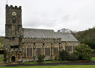
The Church of St Nicholas and St Faith is a Church of England parish church in Saltash, Cornwall. The church is a grade I and II listed building.

St Germans and Landulph was an electoral division of Cornwall in the United Kingdom which returned one member to sit on Cornwall Council between 2013 and 2021. It was abolished at the 2021 local elections, being succeeded by Lynher, Saltash Trematon and Landrake and Rame Peninsula and St Germans.

