St Pinnock

Last updated • 4 min readFrom Wikipedia, The Free Encyclopedia

St Pinnock
Road junction for St Pinnock - geograph.org.uk - 1539418.jpg
Road junction for St Pinnock
Cornwall UK mainland location map.svg
Red pog.svg
St Pinnock
Location within Cornwall
Population676 United Kingdom Census 2011 including Connonu
Civil parish
  • St Pinnock
Shire county
Region
Country England
Sovereign state United Kingdom
Post town Liskeard
Postcode district PL14
Police Devon and Cornwall
Fire Cornwall
Ambulance South Western
List of places
UK
England
Cornwall
50°26′31″N4°32′02″W / 50.442°N 4.534°W / 50.442; -4.534
Historical map of St Pinnock Historical map of St pinnock.png
Historical map of St Pinnock

St Pinnock (Cornish : Sen Pynnek) is a hamlet and civil parish in southeast Cornwall, England, United Kingdom, 3 miles (5 km) south-west of Liskeard. Other settlements in the parish include East Taphouse, and Penfrane, [1] containing 421 inhabitants. [2] The parish church, dedicated to St Pynnochus (Winnoc), is located at OS Grid Ref SX200630.

Contents

To the north, the parish is bordered by St Cleer and St Neot parishes, to the east by Dobwalls and Trewidland parish, to the south by Lanreath and Duloe parishes and to the west by Braddock parish. In 1851 the parish of Herodsfoot was created from parts of St Pinnock, Lanreath and Duloe parishes. [3] The parish of St Pinnock has always been in the Liskeard Registration District. [4] The A390 road runs through the north of the parish.

In the 1870s, St Pinnock was described as:

PINNOCK (St.), a parish in Cornwall; adjacent to the Cornwall railway, 3¼ miles ; and 1¼ S of Doublebois r. station. Post-town. Acres, 3, 487. Real property, £2, 464; of which £350 are in mines. Pop., 571. Houses, 104. The property is subdivided. The living is a rectory in the diocese of Exeter. Value, £285.* Patrons, A. Coryton, Esq., the Rev. E. J. Treffry, and the Rev. J. Rawlings. The church is very ancient, and has a tower. There are chapels for Bible Christians and Calvinistic Methodists, and a free school. [5]

Population structure of St Pinnock

The parish population at the 2001 census was 621; at the 2011 census it had increased to 673. [6] According to the 2011 Census there were 315 males and 361 females living in the parish. [7] The following graph shows the changes between 1880 and 2001, the graph shows that there was a gradual decrease in the population of St Pinnock between 1850 and 1950, however, after 1950 there was a steep increase in the population of St Pinnock.

Total Population of St Pinnock between 1800 and 2011 St Pinnock.jpg
Total Population of St Pinnock between 1800 and 2011

1881 occupational structure

1881 Occupational Structure 1881 Occupational Structure.jpg
1881 Occupational Structure

The 1881 occupational structure of St Pinnock, according to statistics gathered from Vision of Britain, [8] shows that agriculture was the largest occupation taken up by men, followed by work in mineral substances (there was a lead and silver mine called Herod's Foot). The majority of women in 1881 worked in domestic services or offices.

Poor law union

On 1 February 1837 the Liskeard Union for Poor Law and administration and parish relief was formed which included the parish of St Pinnock. [9]

Churches and schools

St Pinnock Church St. Pinnock church, east end - geograph.org.uk - 492458.jpg
St Pinnock Church
Connon Methodist Church Connon Methodist Church - geograph.org.uk - 492524.jpg
Connon Methodist Church

The Church of England parish church of St Pynnochus (Winnoc), is a Grade I listed building [10] but closed for worship in 2017. The parish church lies on the edge of the hamlet of St Pinnock, where there are two Methodist chapels: Connon Chapel and Trevelmond Chapel, located within the parish. The parish has a Church of England Primary School and a Community Hall, both at East Taphouse. [11]

The medieval church building was cruciform but the present structure is mainly of the 14th century; it was over-restored in Victorian times. The rectory was attached to the manor of Penvrane before 1226. [12] The church was reopened on 18 April 1882 following a rebuild of the south chapel which serves as a vestry. The nave roof was restored and seats of pitchpine installed in the nave and aisle. [13] A chapel of All Saints is mentioned in 1437. Bosent Cross is a fine 14th-century cross; the cross in the rectory garden came from Towednack. [14]

The church was described on the Heritage at Risk Register as a:

Small parish church. Norman cruciform origins with C15 north aisle and nave rebuilds, the tower of C14, C16 south porch. Coursed rubble with granite dressings. Cornish slated roofs with some slates slipped. Damp tower with much vegetation growth and problem downpipe on the north side. [15]

The parish church has closed and, in 2019, is available for sale. [16] It has been on the Heritage at Risk Register. [17]

St Pinnock Viaduct

St Pinnock Viaduct St. Pinnock Viaduct, Cornwall. - geograph.org.uk - 69998.jpg
St Pinnock Viaduct

The railway line through the parish was constructed by the Cornwall Railway company.. The line runs between Plymouth and Truro. The railway opened in 1859 and was extended to Falmouth in 1863.

The St Pinnock railway Viaduct, was built in 1854-5 by Isambard Kingdom Brunel and heightened in 1882. It consists of seven piers of roughly dressed, coursed slatestone from Westwood quarry. It stands at approximately 60 foot with each pier consisting of eight buttresses with weatherings rising to form five stages with pointed openings piercing the 4 upper stages. Batter of about 1 in 100. In 1882 the piers were heightened with a slightly cruder, tapering, sixth stage and iron girders were used to replace Brunel's timber trestles. The two-track railroad of 1882 and later carried on rivetted plate steel girders with steel guardrails and refuges to the north side. It is considered the tallest viaduct on the railway in Cornwall, at 633 feet in length and 151 feet in height. [18] [19]

The line was singled over the viaduct on 24 May 1964 to reduce the load on the structure. Beneath the viaduct is the Trago Mills out-of-town shopping complex. [20]

Related Research Articles

<span class="mw-page-title-main">Saltash</span> Town in Cornwall, England

Saltash is a town and civil parish in south Cornwall, England. It had a population of 16,184 in 2011 census. Saltash faces the city of Plymouth over the River Tamar and is popularly known as "the Gateway to Cornwall". Saltash’s landmarks include the Tamar Bridge which connects Plymouth to Cornwall by road, and the Royal Albert Bridge. The area of Latchbrook is part of the town.

<span class="mw-page-title-main">Towednack</span> Human settlement in England

Towednack is a churchtown and civil parish in Cornwall, England, United Kingdom. The parish is bounded by those of Zennor in the west, Gulval in the south, Ludgvan in the west and south, and St Ives and the Atlantic Ocean in the north and east. The church is about two miles (3 km) from St Ives and six miles (10 km) from Penzance.

<span class="mw-page-title-main">Lanreath</span> Human settlement in England

Lanreath is a civil parish and a village in southeast Cornwall, England, United Kingdom. The village is situated five miles (8 km) west-northwest of Looe. The name Lanreath means 'church (Lann) of Raydhogh' and it has been known variously as Lanreythow, Lanrathew, or Lanrethou. The village is mentioned in the Domesday Book as Lanredoch.

<span class="mw-page-title-main">Calstock</span> Village and civil parish in England

Calstock is a civil parish and a large village in south east Cornwall, England, United Kingdom, on the border with Devon. The village is situated on the River Tamar 6 miles (9.7 km) south west of Tavistock and 10 miles (16 km) north of Plymouth.

<span class="mw-page-title-main">Quethiock</span> Village in Cornwall, England

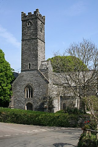
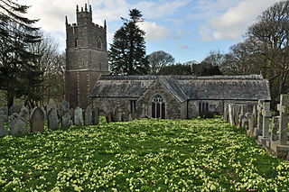
Quethiock is a village and civil parish in Cornwall, England, United Kingdom, roughly five miles east of Liskeard. According to the 2001 census the parish had a population of 429, increasing to 443 at the 2011 census. The ancient parish church of St Hugh is one of the most notable in Cornwall. The placename derives from the Old Cornish cuidoc meaning wooded place. In 1871 the population was 661 and the area 4,351 acres (17.61 km2).

<span class="mw-page-title-main">Braddock, Cornwall</span> Human settlement in England

Braddock is a village and civil parish in Cornwall, England, United Kingdom. The village is about seven miles west of Liskeard, and five miles south-east of Bodmin. The parish was called Broadoak until 1 April 2021.

<span class="mw-page-title-main">Roche, Cornwall</span> Village in Cornwall, England

Roche is a civil parish and village in mid-Cornwall, England, United Kingdom. The village gets its name from the 20-metre (66-foot) high Roche Rock, a quartz-schorl outcrop east of the village. Roche is the Norman-French word for Rock. The parish population at the 2011 census including Belowda, Bilberry, Carbis, Coldvreath and Criggan is 3,381, and the ward population at the same census was 3,867.

<span class="mw-page-title-main">Ruan Lanihorne</span> Village and civil parish in south Cornwall, England

Ruan Lanihorne is a civil parish and village in south Cornwall, England, United Kingdom. The village is situated approximately four miles (6.5 km) east-southeast of Truro between the River Fal and its tributary the Ruan River.

<span class="mw-page-title-main">St Juliot</span>

St Juliot is a civil parish in north-east Cornwall, England, United Kingdom. The parish is entirely rural and the settlements within it are the hamlets of Beeny and Tresparrett. - plus a part of the adjacent village of Marshgate. The parish population at the 2011 census was 328.

<span class="mw-page-title-main">Herodsfoot</span> Village in Cornwall, England

Herodsfoot is a village in southeast Cornwall, England, United Kingdom. It is situated approximately four miles (6 km) southwest of Liskeard and five miles (8 km) north of Looe at a point where two tributaries of the West Looe river join. It is in the civil parish of Lanreath

<span class="mw-page-title-main">St Winnow</span> Human settlement in England

St Winnow is a civil parish in Cornwall, England, United Kingdom. Its name may be connected with either that of Saint Winnoc or Saint Winwaloe. It has a population of 304, which had increased to 328 at the 2011 census. The church town is on the east bank of the River Fowey south of Lostwithiel. Part of the village of Lerryn lies within the parish as does the Chapel of St Nectan. The Redlake Meadows & Hoggs Moor, a Site of Special Scientific Interest is also in the parish.

<span class="mw-page-title-main">Menheniot</span> Human settlement in England

Menheniot is a civil parish and village in Cornwall, England, United Kingdom. The village is 2+12 miles (4.0 km) southeast of Liskeard. The meaning of the name is "sanctuary of Neot".

<span class="mw-page-title-main">Helland</span> Human settlement in England

Helland is a civil parish and village in Cornwall, England, United Kingdom. It is situated 2+12 miles (4.0 km) north of Bodmin. The meaning of the name Helland is unclear: it is possible that the origin is in Cornish hen & lan. The original dedication of the church is unknown but St Helena is now recognised as the patron.

<span class="mw-page-title-main">Withiel</span> Human settlement in England

Withiel is a civil parish and village in mid Cornwall, England, United Kingdom. The parish of Withiel is between the parishes of St Breock, Lanivet, Roche and St Wenn. The name Withiel comes from the Cornish word Gwydhyel, meaning "wooded place". The parish contains the hamlets of Withielgoose, Retire and Tregawne; the parish had a total population of about 300 in 1824.

<span class="mw-page-title-main">St Just in Penwith Parish Church</span> Church in Cornwall, England

St Just in Penwith Parish Church is a parish church in the Church of England located in St Just in Penwith, Cornwall, UK.

<span class="mw-page-title-main">Lansallos</span> Human settlement in England

Lansallos is a village in the civil parish of Polperro in south Cornwall, England, United Kingdom. It is situated between Polruan and Polperro about 5 miles (8 km) east of Fowey in Liskeard Registration District.

<span class="mw-page-title-main">St Giles on the Heath</span> Village and civil parish in west Devon, England

St Giles on the Heath, sometimes hyphenated as St Giles-on-the-Heath, is a village and civil parish in the far west of Devon, England. It forms part of the local government district of Torridge. The village is in the east of the parish and lies on the A388 road about eight miles south of the town of Holsworthy.

<span class="mw-page-title-main">St Julitta's Church, St Juliot</span> Church in Cornwall, England

St Julitta's Church, St Juliot is a Grade II* listed parish church in the Church of England Diocese of Truro in St Juliot, Cornwall.

<span class="mw-page-title-main">St Martin's Church, St Martin-by-Looe</span> Church in Cornwall, England

St Martin's Church is a parish church in the hamlet of St Martin, Looe, Cornwall, in the Church of England Diocese of Truro.

<span class="mw-page-title-main">Liskeard South and Dobwalls (electoral division)</span> Electoral division of Cornwall in the UK

Liskeard South and Dobwalls is an electoral division of Cornwall in the United Kingdom and elects one member to sit on Cornwall Council. The current councillor is Jane Pascoe, a member of the Conservative Party.

References

  1. Ordnance Survey One-inch Map of Great Britain; Bodmin and Launceston, sheet 186. 1961
  2. "British history online" . Retrieved 23 March 2017.
  3. Cornish Church Guide (1925) Truro: Blackford; p. 109
  4. "GEN UKI" . Retrieved 23 March 2017.
  5. Wilson, John Marius (1870–72). Imperial Gazetteer of England and Wales. Edinburgh: A. Fullerton & Co.
  6. "Parish population census 2011" . Retrieved 9 February 2015.
  7. "<Placements> (Parish): Key figures for 2011 Census: Key Statistics". Neighbourhood Statistics. Office for national statistics. Retrieved 2 February 2017.
  8. "St Pinnock CP/AP — Current theme: Industry" . Retrieved 3 April 2017.
  9. "GENUKI: St Pinnock Cornwall" . Retrieved 2 May 2017.
  10. "Church of St Pynnochus, St. Pinnock - Cornwall" . Retrieved 22 March 2017.
  11. "St Pinnock Parish Council" . Retrieved 22 March 2017.
  12. The Cornish Church Guide. Truro: Blackford; p. 185
  13. "St Pinnock Church". The Cornishman. Vol. 197, no. 187. 20 April 1882. p. 4.
  14. Cornish Church Guide; p, 185
  15. "Church of St Pynnochus, St. Pinnock - Cornwall (UA)" . Retrieved 10 January 2019.
  16. Aston, Daniel (3 January 2019). "You can own a 14th century former church complete with bell tower" . Retrieved 10 January 2019.
  17. "Church of St Pynnochus, St. Pinnock - Cornwall (UA)" . Retrieved 10 January 2019.
  18. "St. Pinnock Viaduct" . Retrieved 23 March 2017.
  19. Historic England. "ST PINNOCK VIADUCT (1137633)". National Heritage List for England . Retrieved 23 March 2017.
  20. "St. Pinnock Viaduct" . Retrieved 23 March 2017.

Commons-logo.svg Media related to St Pinnock at Wikimedia Commons