Batabat

Last updated
Batabat
Batabat golu, 2024-cu il.jpg
Batabat Lake in 2024
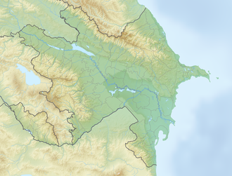
Reliefkarte Aserbaidschan 2023.png
Red pog.svg
Batabat
Location South Caucasus, Azerbaijan
Coordinates 39°32′20″N45°47′02″E / 39.539°N 45.784°E / 39.539; 45.784
Type tarn
Max. length0.6 km (0.37 mi)
Max. width0.6 km (0.37 mi)
Surface area0.16 km2 (0.062 sq mi)
Surface elevation2,500 m (8,200 ft)

Batabat ( Azerbaijani: Batabat) is a tarn in the South Caucasus.

It is located in Azerbaijan, in the mountains of Shahbuz District, Nakhichivan Autonomous Republic. Located at an elevation of 2,500 meters above sea level. There is a lake with a 16 ha area is remarkable with a peaty island floating on the surface of the water. There are also natural springs that mineralized with carbonate, hydrocarbonate, and potassium-sodium-magnesium around the lake, which treats Gastrointestinal diseases.
Related Research Articles

<span class="mw-page-title-main">Geography of Armenia</span>

Armenia is a landlocked country in the South Caucasus region of the Caucasus. The country is geographically located in West Asia, within the Armenian plateau. Armenia is bordered on the north and east by Georgia and Azerbaijan and on the south and west by Iran, Azerbaijan's exclave Nakhchivan, and Turkey.

<span class="mw-page-title-main">Ardabil province</span> Province in Region 3, Iran

Ardabil Province is one of the 31 provinces of Iran. Its capital is the city of Ardabil. The province is in the northwest of the country, in Region 3, bordering the Republic of Azerbaijan, and the Iranian provinces of East Azerbaijan, Zanjan, and Gilan. Spanning an area of 18,011 km2, and established in 1993, Ardabil was carved out of the eastern part of East Azerbaijan Province.

<span class="mw-page-title-main">East Azerbaijan province</span> Province of Iran

East Azerbaijan Province is one of the 31 provinces of Iran. Its capital is the city of Tabriz. The province is located in Iranian Azerbaijan, bordering Armenia, the Republic of Azerbaijan, Ardabil Province, West Azerbaijan Province, and Zanjan Province. East Azerbaijan is in Region 3 of Iran, with its secretariat located in its capital city, Tabriz.

<span class="mw-page-title-main">Azerbaijan (Iran)</span> Historical region in northwestern Iran

Azerbaijan or Azarbaijan, also known as Iranian Azerbaijan, is a historical region in northwestern Iran that borders Iraq and Turkey to the west, and the Nakhchivan Autonomous Republic, Armenia, and the Republic of Azerbaijan proper to the north.

<span class="mw-page-title-main">Lake Urmia</span> Salt lake in Iran

Lake Urmia is an endorheic salt lake in Iran. The lake is located between the provinces of East Azerbaijan and West Azerbaijan in Iran, and west of the southern portion of the Caspian Sea. At its greatest extent, it was the largest lake in the Middle East and the sixth-largest saltwater lake on Earth, with a surface area of approximately 5,200 km2 (2,000 sq mi), a length of 140 km (87 mi), a width of 55 km (34 mi), and a maximum depth of 16 m (52 ft).

<span class="mw-page-title-main">Qabala District</span> District of Azerbaijan

Qabala District is one of the 66 districts of Azerbaijan. It is located in the north of the country in the Shaki-Zagatala Economic Region. The district borders the districts of Oghuz, Shaki, Agdash, Goychay, Ismayilli, Quba, Qusar, and the Russian Republic of Dagestan. Its capital and largest city is Qabala. As of 2020, the district had a population of 107,800.

<span class="mw-page-title-main">Goygol District</span> District of Azerbaijan

Goygol District is one of the 66 districts of Azerbaijan. It is located in the west of the country and belongs to the Ganja-Dashkasan Economic Region. The district borders the districts of Goranboy, Kalbajar, Dashkasan, Shamkir, Samukh, and the city of Ganja. Its capital and largest city is Goygol. As of 2020, the district had a population of 64,600.

<span class="mw-page-title-main">Shahbuz District</span> District of Nakhchivan Autonomous Republic in Azerbaijan

Shahbuz District is one of the 7 districts of the Nakhchivan Autonomous Republic of Azerbaijan. The district borders the districts of Julfa, Babek, and the Syunik and Vayots Dzor provinces of Armenia. Its capital and largest city is Shahbuz. As of 2020, the district had a population of 25,300.

<span class="mw-page-title-main">Buenavista, Quezon</span> Municipality in Quezon, Philippines

Buenavista, officially the Municipality of Buenavista, is a 4th class municipality in the province of Quezon, Philippines. According to the 2020 census, it has a population of 31,160 people.

<span class="mw-page-title-main">State reserves of Azerbaijan</span>

State Reserves of Azerbaijan refers to the state reserves in Azerbaijan, which preserve the fauna, flora and their ecosystems.

<span class="mw-page-title-main">Bodies of water of Azerbaijan</span>

The water bodies of Azerbaijan were formed over a long geological timeframe and changed significantly throughout that period. This is particularly evidenced by remnants of ancient rivers found throughout the country. The country's water systems are continually changing under the influence of natural forces and human-introduced industrial activities. Artificial rivers (canals) and ponds are a part of Azerbaijan's water systems.

<span class="mw-page-title-main">Voghji (river)</span> River in Armenia, Azerbaijan

The Voghji or Okchuchay is a river on the south slopes of the Lesser Caucasus range, and is a left tributary of the Aras. It flows through the territory of Armenia and Azerbaijan.

<span class="mw-page-title-main">Lake Boyukshor</span> Endorheic lake in Absheron Peninsula, Azerbaijan

Boyukshor, also spelled separately Boyuk Shor, is the second-largest lake of Azerbaijan and the largest on Absheron Peninsula. It is located in the center of the Absheron peninsula, on the boundaries of Binagadi, Sabunchu and Narimanov raions of the city of Baku.

<span class="mw-page-title-main">Caspian Sea</span> Lake in Eurasia – the worlds largest lake

The Caspian Sea is the world's largest inland body of water, often described as the world's largest lake and sometimes referred to as a full-fledged sea. An endorheic basin, it lies between Europe and Asia: east of the Caucasus, west of the broad steppe of Central Asia, south of the fertile plains of Southern Russia in Eastern Europe, and north of the mountainous Iranian Plateau. It covers a surface area of 371,000 km2 (143,000 sq mi), an area approximately equal to that of Japan, with a volume of 78,200 km3 (19,000 cu mi). It has a salinity of approximately 1.2%, about a third of the salinity of average seawater. It is bounded by Kazakhstan to the northeast, Russia to the northwest, Azerbaijan to the southwest, Iran to the south, and Turkmenistan to the southeast.

<span class="mw-page-title-main">Boyuk Alagol</span> Crater lake in Kalbajar District, Azerbaijan

Boyuk Alagol is a lake in the Kalbajar District of Azerbaijan. It is located on the Karabakh volcanic plateau. Its area is 5.1 square kilometres (2.0 sq mi) and the volume of water reaches 24,300,000 m3 (860,000,000 cu ft). The Boyuk Alagol is located at an altitude of 2729 meters above sea level. The surface of the lake is covered with ice up to one meter thick from early November to late April. The water temperature is 14–15 degrees from June to August.

<span class="mw-page-title-main">Jandari Lake</span>

Jandari Lake is a lake on the Azerbaijan–Georgia border, it is located in south-east Georgia and north-west Azerbaijan, at 291,4 metres above sea level. The lake's surface area is 10.6 km2, while the catchment area is 102 km2. The maximal depth is 7.2 m. Some 67% of the basin is located on Georgian territory and 33% in Azerbaijan.

<span class="mw-page-title-main">West Azerbaijan province</span> Province of Iran

West Azerbaijan province is one of the 31 provinces of Iran, whose capital and largest city is Urmia. It is in the northwest of the country, bordered by Turkey, Iraq and Azerbaijan's Nakhchivan Autonomous Republic, as well as the Iranian provinces of East Azerbaijan, Zanjan, and Kurdistan. West Azerbaijan province is part of Region 3. It is separated from Armenia by Turkey's short border with the Azerbaijan Republic. The province covers an area of 39,487 km2, or 43,660 km2 including Lake Urmia.

<span class="mw-page-title-main">Borders of Azerbaijan</span> Political border

The Borders of Azerbaijan define the land and maritime borders of Azerbaijan. Azerbaijan has international land borders with 5 states.

The Azerbaijan is a country with very favorable natural conditions and rich natural resources. Snowy peaks, high mountains, foothill fertile soils, wide plains, Lowest Land Points Below Ocean Level are the main landscape forms of the republic. This complex landscape structure has resulted in a variety of natural conditions, climate, soil-vegetation, and water resources. This, in turn, led to the uneven distribution of population and farms on the territory, and the specialization of production on different types.

Mineral waters of Nakhchivan are water springs in Nakhchivan Autonomous Republic that contain various minerals such as, sodium, potassium, magnesium, chloride and sulfur compounds.