
Calhoun County is a county in the U.S. state of Michigan. As of the 2020 Census, the population was 134,310. The county seat is Marshall. The county was established on October 19, 1829, and named after John C. Calhoun, who was at the time Vice President under Andrew Jackson, making it one of Michigan's Cabinet counties. County government was first organized on March 6, 1833. Calhoun County comprises the Battle Creek Metropolitan Statistical Area and is included in the Kalamazoo-Battle Creek-Portage Combined Statistical Area.

Bedford Charter Township is a charter township located in the northwest corner of Calhoun County in the U.S. state of Michigan. It is part of the Battle Creek, Michigan Metropolitan Statistical Area. As of the 2020 census, the township population was 9,198. Most of the township lies north of the Kalamazoo River and the city of Battle Creek. Three small noncontiguous areas of the township lie south of the Kalamazoo River.
Clarence Township is a civil township located in northeast Calhoun County in the U.S. state of Michigan. It is part of the Battle Creek, Michigan Metropolitan Statistical Area. The population was 1,903 at the 2020 census. The township was originally named Pinkney Township.

Emmett Charter Township is a charter township of Calhoun County in the U.S. state of Michigan. It is part of the Battle Creek Metropolitan Statistical Area. The population was 11,744 at the 2020 census.

Comstock Charter Township is a charter township of Kalamazoo County in the U.S. state of Michigan, located east of the city of Kalamazoo and is part of the Kalamazoo–Portage Metropolitan Area. The 2020 census recorded the population within the township at 15,231.

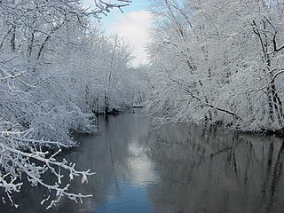
The Kalamazoo River is a river in the U.S. state of Michigan. The river is 130 miles (210 km) long from the junction of its North and South branches to its mouth at Lake Michigan, with a total length extending to 178 miles (286 km) when one includes the South Branch. The river's watershed drains an area of approximately 2,020 square miles (5,200 km2) and drains portions of ten counties in southwest Michigan: Allegan, Barry, Eaton, Van Buren, Kalamazoo, Calhoun, Jackson, Hillsdale, Kent and Ottawa. The river has a median flow of 1,863 cubic feet per second (52.8 m3/s) at New Richmond, upstream from its mouth at Saugatuck and Douglas.

M-89 is an east–west state trunkline highway in the US state of Michigan that runs from near Ganges to Battle Creek. M-89 starts at an interchange with Interstate 196/US Highway 31 (I-196/US 31) and passes through Allegan, Kalamazoo County, Michigan, and Calhoun counties. The highway also briefly crosses the southwest corner of Barry County before it terminates an at intersection with Business Loop I-94 on the northwestern side of downtown Battle Creek. In between the trunkline runs parallel to the Kalamazoo River through rural southwestern Michigan farmlands while also running through the middle of several smaller towns in the area.
The Paw Paw River is located in the U.S. state of Michigan in the southwest portion of the lower peninsula. It is formed by the confluence of the north and south branches at 42°15′17″N85°55′36″W in Waverly Township in the northeast of Van Buren County. It flows approximately 61.8 miles (99.5 km) through Van Buren County and Berrien County until joining the St. Joseph River just above its mouth on Lake Michigan at Benton Harbor.
The Tiffin River is a 54.9-mile-long (88.4 km) tributary of the Maumee River in northwestern Ohio in the United States. Headwater tributaries of the river rise in southeastern Michigan. The river drains a primarily rural farming region in the watershed of Lake Erie. Early French traders called the river Crique Féve, translated as Bean Creek, due to the natural growth of bean plants along the shores.

The Ottawa River, also known as Ottawa Creek, is a short river, approximately 20 miles (32 km) long, in northwest Ohio and southeast Michigan in the United States. It drains an area on the Ohio-Michigan border along the eastern and northern fringes of the city of Toledo, goes through Ottawa Hills, and empties directly into Lake Erie. It is one of two rivers in northwestern Ohio that share the same name, along with the Ottawa River that is a tributary of the Auglaize River. The upper 4 miles (6 km) of the river in Michigan north of Sylvania, Ohio is called North Tenmile Creek on federal maps, while another branch rising in Fulton County, Ohio, is called Tenmile Creek.

The Rabbit River is a 62.1-mile-long (99.9 km) tributary of the Kalamazoo River within Allegan County in the U.S. state of Michigan. The river's watershed covers 187,200 acres (758 km2) of land and drains most of north-central and northeast Allegan County as well as small portions of Barry, Kent and Ottawa counties.

Portage River is a 38.6-mile-long (62.1 km) river that flows southward through Kalamazoo County and St. Joseph County, Michigan. Its headwaters are 8 miles (13 km) east of the city of Kalamazoo at Portage Lake, and the river flows southwest to its mouth within the city limits of Three Rivers, where it drains into the St. Joseph River.
Coldwater River is a 29.5-mile-long (47.5 km) stream in the U.S. state of Michigan. Located in Branch County, the river rises in Ovid Township at 41°50′14″N84°59′13″W as the outflow of Coldwater Lake. Flowing north and west, it is joined by the outflow from the Lake of the Woods and continues north for several miles. West of the city of Coldwater, it flows through a series of lakes: South Lake, Messenger Lake, Cemetery Lake, North Lake, Randall Lake, Morrison Lake, Craig Lake, and Hodunk Pond. It then continues to the northwest and empties into the St. Joseph River in the village of Union City at 42°03′58″N85°07′48″W.
Coldwater River is a 13.1-mile-long (21.1 km) stream in the U.S. state of Michigan. Located in Isabella County, the river rises as the outflow of Littlefield Lake in western Gilmore Township. The river flows mostly south and empties into the Chippewa River at 43°37′22.231″N84°57′38.243″W on the western boundary of Deerfield Township, about two miles east of Lake Isabella.
The Gun River is a 15.1-mile-long (24.3 km) tributary of the Kalamazoo River in Michigan, in the United States. It begins at the outlet of Gun Lake at the border between Allegan and Barry counties and flows southwest through Allegan County to its mouth at the Kalamazoo River just east of Otsego.
Nottawa Creek is a 33.9-mile-long (54.6 km) stream in the U.S. state of Michigan that flows into the St. Joseph River at 42°00′15″N85°23′40″W, approximately three miles east of the village of Mendon.
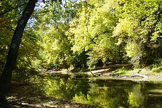
Talmadge Creek is a tributary of the Kalamazoo River. It is located in Calhoun County, Michigan, near the county seat of Marshall.
The Baldwin River is a 25.2-mile-long (40.6 km) stream in the U.S. state of Michigan.
The Carp River is a 10.3-mile-long (16.6 km) river in Gogebic and Ontonagon counties in the U.S. state of Michigan. The Carp River is formed by the outflow of the Lake of the Clouds at 46°48′04″N89°45′38″W in the Porcupine Mountains of the Upper Peninsula.
The Little Carp River is a 15-mile-long (24 km) river in Gogebic and Ontonagon counties in the U.S. state of Michigan. The Carp River rises at 46°45′54″N89°44′44″W in the Porcupine Mountains of the Upper Peninsula.

