
Inyo County is a county in the eastern central part of the U.S. state of California, located between the Sierra Nevada and the state of Nevada. In the 2020 census, the population was 19,016. The county seat is Independence. Inyo County is on the east side of the Sierra Nevada and southeast of Yosemite National Park in Central California. It contains the Owens River Valley; it is flanked to the west by the Sierra Nevada and to the east by the White Mountains and the Inyo Mountains. With an area of 10,192 square miles (26,400 km2), Inyo is the second-largest county by area in California, after San Bernardino County. Almost half of that area is within Death Valley National Park. However, with a population density of 1.8 people per square mile, it also has the second-lowest population density in California, after Alpine County.

Bishop is the most populous and only incorporated city in Inyo County, California, United States. It is located near the northern end of the Owens Valley within the Mojave Desert, at an elevation of 4,150 feet (1,260 m). The city was named after Bishop Creek, flowing out of the Sierra Nevada range; the creek was named after Samuel Addison Bishop, a settler in the Owens Valley. Bishop is a commercial and residential center, while many vacation destinations and tourist attractions in the Sierra Nevada are located nearby. The city covers approximately 1.9 square miles (4.9 km2), making it the county's largest community by population and land area.

Mount Whitney is the highest mountain in the contiguous United States, with an elevation of 14,505 feet (4,421 m). It is in East–Central California, in the Sierra Nevada, on the boundary between California's Inyo and Tulare counties, and 84.6 miles (136.2 km) west-northwest of North America's lowest topographic point, Badwater Basin in Death Valley National Park, at 282 ft (86 m) below sea level. The mountain's west slope is in Sequoia National Park and the summit is the southern terminus of the John Muir Trail, which runs 211.9 mi (341.0 km) from Happy Isles in Yosemite Valley. The eastern slopes are in Inyo National Forest in Inyo County. Mount Whitney is ranked 18th by topographic isolation.

The California Water Wars were a series of political conflicts between the city of Los Angeles and farmers and ranchers in the Owens Valley of Eastern California over water rights.

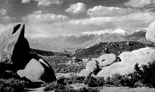
The Owens River is a river in eastern California in the United States, approximately 183 miles (295 km) long. It drains into and through the Owens Valley, an arid basin between the eastern slope of the Sierra Nevada and the western faces of the Inyo and White Mountains. The river terminates at the endorheic Owens Lake south of Lone Pine, at the bottom of a 2,600 sq mi (6,700 km2) watershed.

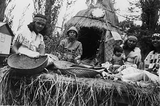
The Mono are a Native American people who traditionally live in the central Sierra Nevada, the Eastern Sierra, the Mono Basin, and adjacent areas of the Great Basin. They are often grouped under the historical label "Paiute" together with the Northern Paiute and Southern Paiute – but these three groups, although related within the Numic group of Uto-Aztecan languages, do not form a single, unique, unified group of Great Basin tribes.
Manzanar was a town in Inyo County, California, founded by water engineer and land developer George Chaffey. Most notably, Manzanar is known for its role in the internment of Japanese Americans during World War II.
Thomas Jefferson Mayfield (1843–1928) led a remarkable double life in the early decades of California statehood, living his boyhood as an adopted member of the Choinumni (Choinumne) branch of the Yokuts tribe in the San Joaquin Valley, then rejoining the dominant Anglo-American community throughout his long adulthood.

Fort Independence, originally named Camp Independence, was a fort located in the Owens Valley, 3 miles (4.8 km) north of present-day Independence, Inyo County, eastern California. The U.S. Army post was active from 1862 to 1877.
Visalia, California, commonly known in the 1850s as Four Creeks, is the oldest continuously inhabited inland European settlement between Stockton and Los Angeles. The city played an important role in the American colonization of the San Joaquin Valley as the county seat of Old Tulare County, an expansive region comprising most if not all of modern-day Fresno, Kings, and Kern counties.
The Bishop Paiute Tribe, formerly known as the Paiute-Shoshone Indians of the Bishop Community of the Bishop Colony is a federally recognized tribe of Mono and Timbisha Indians of the Owens Valley, in Inyo County of eastern California. As of 2022, the United States census showed the Bishop Paiute Tribe's population at 1,914.
The Keyesville massacre was a mass killing which occurred on April 19, 1863, in Tulare County, California during the Owens Valley Indian War. A mixed force consisting of American settlers and a detachment of the United States Army's 2nd California Cavalry Regiment under Captain Moses A. McLaughlin killed 35 indigenous Californians from the Tübatulabal and Mono peoples "about ten miles from Keysville, upon the right bank of Kern River".
The Owens Valley War was fought between 1862 and 1863 by the United States Army and American settlers against the Mono people and their Shoshone and Kawaiisu allies in the Owens Valley of California and the southwestern Nevada border region. The removal of a large number of the Owens River indigenous Californians to Fort Tejon in 1863 was considered the end of the war. Minor hostilities continued intermittently until 1867.

Mayfield Canyon, a canyon northwest of the town of Bishop in Inyo County, California.

San Francis Ranch was the ranch of Owens Valley pioneer Samuel A. Bishop and his wife, located on a creek later named for him southwest of modern Bishop, California also named after him.
William Mayfield (1810–1862) was an American pioneer in Illinois, Texas, and California; a soldier, farmer, miner, and a cattleman. He led Tulare County militia to aid settlers in the early part of the Owens Valley Indian War and was killed in the Battle of Mayfield Canyon.
Benjamin Mayfield was a cowboy and a miner who killed the outlaw John Mason.
Joaquin Jim was an Eastern Mono, war leader of the Owens Valley Indian War. Joaquin Jim, implacable war leader of the Mono allies of the Owens Valley Paiute, never surrendered to American forces or made peace with them, but reported to have ceased warfare against them in 1864.
The California Indian Wars were a series of wars, battles, and massacres between the United States Army, and the Indigenous peoples of California. The wars lasted from 1850, immediately after Alta California, acquired during the Mexican–American War, became the state of California, to 1880 when the last minor military operation on the Colorado River ended the Calloway Affair of 1880.
The Tule River War of 1856 was a conflict where American settlers, and later, California State Militia, and a detachment of the U. S. Army from Fort Miller, fought a six-week war against the Yokuts in the southern San Joaquin Valley.
