Battle of Chusto-Talasah

Last updated
Battle of Chusto-Talasah
Part of the Trans-Mississippi Theater of the
American Civil War
Chusto-Talasah 1.jpg
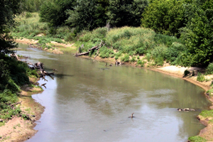
The Chusto-Talasah battlefield as it exists today. Photo taken July 2011 by Jeffrey S. Williams
DateDecember 9, 1861 (1861-12-09)
Location
Result Confederate victory
Belligerents
Creek
Seminole
Flag of the Confederate States of America (1861-1863).svg Confederacy
Cherokee
Choctaw
Commanders and leaders
Opothleyahola Douglas H. Cooper
Strength
2,000–2,500 men [1] [2] 1,300 men
Casualties and losses
9 killed
500 total [2]
15–30 killed
37 wounded
~400 deserted [2]
Map of Chusto-Talasah Battlefield core and study areas by the American Battlefield Protection Program. Chusto-Talasah Battlefield Oklahoma.jpg
Map of Chusto-Talasah Battlefield core and study areas by the American Battlefield Protection Program.
High Voltage Transmission Lines now traverse over the core battlefield land at Chusto-Talasah. Photo taken in July 2011 by Jeffrey S. Williams Chusto-Talasah 2.jpg
High Voltage Transmission Lines now traverse over the core battlefield land at Chusto-Talasah. Photo taken in July 2011 by Jeffrey S. Williams

The Battle of Chusto-Talasah, also known as Bird Creek, Caving Banks, and High Shoal, was fought December 9, 1861, in what is now Tulsa County, Oklahoma (then Indian Territory) during the American Civil War. It was the second of three battles in the Trail of Blood on Ice campaign for the control of Indian Territory during the American Civil War.

Contents

A series of battles were fought in December in bad weather between the Confederate Cherokee and Choctaw Indians and the Union Creek and Seminole Indians (led by the Muscogee Creek chief Opothleyahola) who supported the Federal government. Following Opothleyahola and his Union force’s defeat at Round Mountain, he retreated northeastward in search of safety. On December 9, 1861, the force was at Chusto-Talasah (Caving Banks) on the Horseshoe Bend of Bird Creek when Col. Douglas H. Cooper’s 1,300 Confederates attacked about 2:00 p.m. Chief Opothleyahola knew Cooper was coming and had placed his troops in a strong position in heavy timber at Horseshoe Bend.

For almost four hours, Cooper attacked and attempted to outflank the Federals, finally driving them across Bird Creek just before dark. Cooper camped there overnight but did not pursue the Federals because he was short of ammunition. The Confederates claimed victory, although some sources credit Opothleyahola's forces with driving off the attackers. [3] In any event, Chief Opothleyahola and his band moved on in search of security elsewhere. Their loss was estimated by Cooper as 500 (some accounts suggest 412). Confederate casualties were 15 killed and 37 wounded. [1] [2]

Regardless of whether the Confederates had gained a minor tactical victory here, they would win a resounding one later in the month at Chustenahlah.

The Chusto-Talasah battle site is on privately owned land near 86th Street North and Delaware Avenue, 5 miles northwest of modern Tulsa. [4] A granite marker on the east side of Sperry, Oklahoma places the battlesite 9 miles N.E.S.E. of that point. [3]

Order of battle

Cooper's Brigade - Col. Douglas H. Cooper

Creek and Seminole Indians - Chief Opothleyahola

See also

Related Research Articles

<span class="mw-page-title-main">Tulsa County, Oklahoma</span> County in the United States

Tulsa County is a county located in the U.S. state of Oklahoma. As of the 2020 census, the population was 669,279, making it the second-most populous county in the state, behind only Oklahoma County. Its county seat and largest city is Tulsa, the second-largest city in the state. Founded at statehood, in 1907, it was named after the previously established city of Tulsa. Before statehood, the area was part of both the Creek Nation and the Cooweescoowee District of Cherokee Nation in Indian Territory. Tulsa County is included in the Tulsa metropolitan statistical area. Tulsa County is notable for being the most densely populated county in the state. Tulsa County also ranks as having the highest income.

<span class="mw-page-title-main">Sperry, Oklahoma</span> Town in Oklahoma, United States

Sperry is a town in Tulsa County, Oklahoma, United States. The population was 1,115 at the time of the 2020 census. It is primarily a bedroom community, since approximately 85 percent of the employed residents commute to work in Tulsa and other nearby towns. Sperry also has an active retirement community.

The Battle of Chustenahlah was fought in Osage County, Oklahoma, on December 26, 1861, during the American Civil War. A band of 9,000 pro-Union Native Americans was forced to flee to Kansas in bitter cold and snow in what became known as the Trail of Blood on Ice.

<span class="mw-page-title-main">Battle of Round Mountain</span> Battle of the American Civil War

The Battle of Round Mountain was the first battle in the Trail of Blood on Ice campaign for the control of Indian Territory during the American Civil War that occurred on November 19, 1861. Its main purpose was to prevent Union supporters of the Creek Nation, led by Opothleyahola from fleeing Indian Territory to the protection of Union forces in Kansas.

<span class="mw-page-title-main">Opothleyahola</span> Muscogee Creek chief (d. 1863)

Opothleyahola was a Muscogee Creek Indian chief, noted as a brilliant orator. He was a Speaker of the Upper Creek Council and supported traditional culture.

<span class="mw-page-title-main">Douglas H. Cooper</span> American politician

Douglas Hancock Cooper was an American politician, soldier, Indian Agent in what is now Oklahoma, and Confederate general during the American Civil War.

<span class="mw-page-title-main">1st Cherokee Mounted Rifles</span> Regiment of the Confederate States Army

The 1st Cherokee Mounted Rifles was a cavalry formation of the Confederate States Army in the Trans-Mississippi Theater of the American Civil War.

The Battle of Middle Boggy Depot, also known as the Battle of Middle Boggy River or simply Battle of Middle Boggy, took place on February 13, 1864 in Choctaw Indian Territory, 4 miles (6.4 km) south of what is now Allen in Pontotoc County, Oklahoma. Advancing down the Dragoon Trail toward Fort Washita, Union Colonel William A. Phillips sent out an advance of approximately 350 men from the 14th Kansas Cavalry and two howitzers to attack a Confederate outpost guarding the Trail's crossing of Middle Boggy River. The Confederate force was led by Captain Jonathan Nail and composed of one company of the First Choctaw and Chickasaw Cavalry, a detachment of the 20th Texas Cavalry and part of the Seminole Battalion of Mounted Rifles. The outpost was about 12 miles (19 km) from Muddy Boggy Depot, which was held by the Confederates. The Encyclopedia of Oklahoma History and Culture says that the battlefield was 15 miles northeast of the depot, whereas the battlefield marker says the distance was 12 miles. The Confederate force at the outpost, consisting of 90 poorly armed men, were caught off guard when Willetts attacked them. Outnumbered and outgunned, the Confederates held off the Union cavalry attack for approximately 30 minutes before retreating to the rest of Lt. Col. John Jumper's Seminole Battalion, who were not at the main skirmish. The Confederates retreated 45 miles (72 km) southwest down the Dragoon Trail. The Union advance continued south toward Ft. Washita the next day, but when the expected reinforcements did not arrive Philips' Expedition into Indian Territory stalled on February 15, near old Stonewall.

<span class="mw-page-title-main">Muscogee Nation</span> Federally recognized Native American tribe in Oklahoma

The Muscogee Nation, or Muscogee (Creek) Nation, is a federally recognized Native American tribe based in the U.S. state of Oklahoma. The nation descends from the historic Muscogee Confederacy, a large group of indigenous peoples of the Southeastern Woodlands. They commonly refer to themselves as Este Mvskokvlke. Historically, they were often referred to by European Americans as one of the Five Civilized Tribes of the American Southeast.

Confederate Units of Indian Territory consisted of Native Americans from the Five Civilized Tribes — the Cherokee, Chickasaw, Choctaw, Creek, and Seminole nations. The 1st Cherokee Mounted Rifles were commanded by the highest ranking Native American of the war: Brig. Gen. Stand Watie, who also became the last Confederate General to surrender on June 23, 1865. There was also a series of Union units of Indian Territory.

<span class="mw-page-title-main">Indian Territory in the American Civil War</span>

During the American Civil War, most of what is now the U.S. state of Oklahoma was designated as the Indian Territory. It served as an unorganized region that had been set aside specifically for Native American tribes and was occupied mostly by tribes which had been removed from their ancestral lands in the Southeastern United States following the Indian Removal Act of 1830. As part of the Trans-Mississippi Theater, the Indian Territory was the scene of numerous skirmishes and seven officially recognized battles involving both Native American units allied with the Confederate States of America and Native Americans loyal to the United States government, as well as other Union and Confederate troops.

Sonuk Mikko, commonly known as Billy Bowlegs and also known as So-Nuk-Mek-Ko, was a Seminole who gained recognition as a captain in the American Civil War. Mikko adopted the name of Chief Billy Bowlegs from, who had fought in the Second and Third Seminole Wars, following Holato Micco's death in 1859.

Thlopthlocco Tribal Town is both a federally recognized Native American tribe and a traditional township of Muscogee Creek Indians, based in Oklahoma. The tribe's native language is Mvskoke, also called Creek.

<span class="mw-page-title-main">Choctaw in the American Civil War</span>

The Choctaw in the American Civil War participated in two major arenas—the Trans-Mississippi and Western Theaters. The Trans-Mississippi had the Choctaw Nation. The Western had the Mississippi Choctaw. The Choctaw Nation had been mostly removed west prior to the War, but the Mississippi Choctaw had remained in the east. Both the Choctaw Nation and the Mississippi Choctaw would ultimately side with the Confederate States of America.

The Trail of Blood on Ice was a December 1861 campaign in the American Civil War in which pro-Union Native Americans, led by Upper Creek Chief Opothleyahola, fought their way north from Indian Territory to Fort Row, Kansas. They faced continuing attacks from Confederate forces under Col. Douglas H. Cooper.

<span class="mw-page-title-main">Bird Creek</span> River

Bird Creek is a stream in northeast Oklahoma. The main creek is formed from the waters of North Bird Creek, Middle Bird Creek, and South Bird Creek, all of which rise in Osage County. The South and Middle branches of the creek converge at Bluestem Lake. Outflow from the lake is called Middle Bird Creek. North Bird Creek joins Middle Bird Creek northwest of Pawhuska, and from that point on is simply Bird Creek. From Pawhuska, the creek flows southeastward and eastward through the north side of the Tulsa metropolitan area, before reaching its mouth at the Verdigris River near Catoosa. Major tributaries include Birch Creek, Hominy Creek and Mingo Creek. There are numerous minor tributaries, both named and unnamed, that have contributed to historical flooding problems in the Tulsa area.

<span class="mw-page-title-main">John Drew (Cherokee)</span> Cherokee leader (1796–1865)

John Thompson Drew was a mixed blood military and political leader of the Cherokee Nation. Born in 1796, there is little written about his life until he led a company of Cherokee emigrants from Georgia to Indian Territory. He is best known for joining the Confederate army at the outbreak of the American Civil War, when he raised, organized and led the 1st Cherokee Mounted Rifles.

The Seminole in the American Civil War were found in both the Trans-Mississippi and Western Theaters. The Seminole Nation in the Trans-Mississippi Theater had split alliances. However, the majority of the tribe in the Western territories joined the Union Army under the leadership of Billy Bowlegs. Others, such as John Jumper, supported the Confederacy. The Florida Seminole participated in some skirmishing in central Florida. They were likely at the Battle of Olustee in February 1864.

<span class="mw-page-title-main">9th Texas Cavalry Regiment</span> Military unit

The 9th Texas Cavalry Regiment was a unit of mounted volunteers that fought in the Confederate States Army during the American Civil War. The regiment fought at Round Mountain and Bird Creek (Chusto-Talasah) in 1861, Pea Ridge, Siege of Corinth, Second Corinth, Hatchie's Bridge and the Holly Springs Raid in 1862, and in the Atlanta campaign, Franklin, and Murfreesboro in 1864. The unit fought dismounted at Second Corinth and Hatchie's Bridge before being remounted as cavalry for the remainder of the war. The regiment surrendered to Federal forces on 4 May 1865 and its remaining personnel were paroled.

References

  1. 1 2 Jason T. Harris (2008). Combat, Supply, and the Influence of Logistics During the Civil War in Indian Territory. p. 32. ISBN   978-0-549-51337-7 . Retrieved 20 January 2013.
  2. 1 2 3 4 Lela Jean McBride Brockway Tindle (2000). Opothleyaholo and the Loyal Muskogee: Their Flight to Kansas in the Civil War. McFarland. pp. 168–169. ISBN   978-0-7864-0638-8 . Retrieved 19 January 2013.
  3. 1 2 Oklahoma Historical Society granite marker on the east side of Sperry says: "Battle of Chusto-Talasah This battle site is 9 miles N.E.S.E., at the “Caving Banks” bend on Bird Creek. Here-Dec. 9, 1861- Opothleyahola’s Union Indians forced the retreat of Col. D.H. Cooper’s Confederate troops. Marker sponsored by the Tulsa County Historical Society. Oklahoma Historical Society.”
  4. THE WAR BETWEEN THE STATES IN INDIAN TERRITORY. "Battle of Chusto-Talasah December 9, 1861." Accessed August 23, 2012.

36°16′56″N95°57′01″W / 36.2823°N 95.9502°W / 36.2823; -95.9502