
Pelagonia is a geographical region of Macedonia named after the ancient kingdom. Ancient Pelagonia roughly corresponded to the present-day municipalities of Bitola, Prilep, Mogila, Novaci, Kruševo, and Krivogaštani in North Macedonia and to the municipalities of Florina, Amyntaio and Prespes in Greece.
Sittingbourne and Milton was an urban district in Kent, England, consisting of the settlements of Sittingbourne and Milton Regis. It was abolished in 1974 under the Local Government Act 1972, and made part of the Swale district.

Matlab Dakshin is an upazila of Chandpur District in the division of Chittagong, Bangladesh. The former Matlab Upazila was bifurcated in 2000, creating Matlab Dakshin and Matlab Uttar upazilas.

Shibchar is an upazila of Madaripur District in the Division of Dhaka, Bangladesh.

Bagherpara is an upazila of Jessore District in the Division of Khulna, Bangladesh.

Maheshpur Upazila is a part of Jhenaidah District in the Khulna Division of Bangladesh.

Findlay Creek is a suburban neighbourhood in Riverside South-Findlay Creek Ward in the south end of Ottawa, Ontario, Canada. According to the 2021 Canadian Census, the population of the community was 14,089 and there were 4,395 dwellings.
Quivilla District is one of nine districts of the province Dos de Mayo in Peru.
Ngoy is a district (muang) of Luang Prabang province in northern Laos.
Brzeziny is a village in the administrative district of Gmina Rzeczyca, within Tomaszów Mazowiecki County, Łódź Voivodeship, in central Poland. It lies approximately 5 kilometres (3 mi) east of Rzeczyca, 25 km (16 mi) east of Tomaszów Mazowiecki, and 65 km (40 mi) east of the regional capital Łódź.
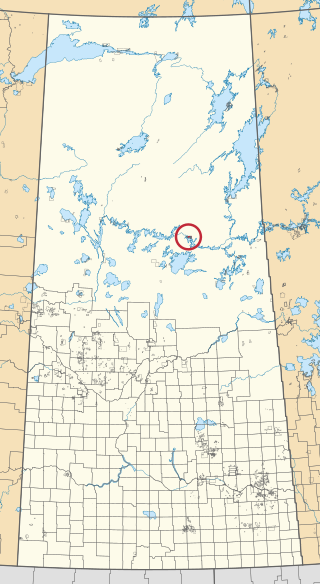
Grandmother's Bay 219 is an Indian reserve of the Lac La Ronge Indian Band in Saskatchewan. Located on Otter Lake, part of the Churchill River system, it is about 77 kilometres (48 mi) north-east of Lac la Ronge. In the 2016 Canadian Census, it recorded a population of 342 living in 101 of its 115 total private dwellings. In the same year, its Community Well-Being index was calculated at 44 of 100, compared to 58.4 for the average First Nations community and 77.5 for the average non-Indigenous community.

The Bear at Home is an English 16th-century public house in the South Oxfordshire village of North Moreton, near Wallingford. It retains many original 16th-century features, including timber-framed walls, inglenook fireplace and a well, and was extended in 1980 to allow it to serve food. As recently as 1930, there were four pubs in this small village, serving a population of about 400 people.

The Battle of Lutterberg took place on 10 October 1758 during the Seven Years' War between a French force of 42,000 commanded by Charles, Prince of Soubise and a much smaller Anglo-German force commanded by General Christoph Ludwig von Oberg.
The O-Chi-Chak-Ko-Sipi First Nation is a First Nations community in Manitoba.
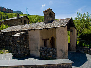
Església de la Santa Creu de Canillo is a small church located in Canillo, Andorra. It is a heritage property registered in the Cultural Heritage of Andorra. It was built in the 17-18th century.
The Royal Harbour Academy is a coeducational secondary school and sixth form located over two sites in Ramsgate in the English county of Kent.
Atchannou is an arrondissement in the Mono department of Benin. It is an administrative division under the jurisdiction of the commune of Athiémè. According to the population census conducted by the Institut National de la Statistique Benin on February 15, 2002, the arrondissement had a total population of 7176.
Dédékpoé is an arrondissement in the Mono department of Benin. It is an administrative division under the jurisdiction of the commune of Athiémè. According to the population census conducted by the Institut National de la Statistique Benin on February 15, 2002, the arrondissement had a total population of 3,128.
Kpinnou is an arrondissement in the Mono department of Benin. It is an administrative division under the jurisdiction of the commune of Athiémè. According to the population census conducted by the Institut National de la Statistique Benin on February 15, 2002, the arrondissement had a total population of 7,630.
Cordillera is a corregimiento, a subdivision of a district, in Boquerón District, Chiriquí Province, Panama. It has a land area of 49.3 square kilometres (19.0 sq mi) and had a population of 590 as of 2010, giving it a population density of 12 inhabitants per square kilometre (31/sq mi). Its population as of 1990 was 361; its population as of 2000 was 471.
