
Alachua County is a county in the north central portion of the U.S. state of Florida. As of the 2020 census, the population was 278,468. The county seat is Gainesville, the home of the University of Florida.

The Seminole Wars were a series of three military conflicts between the United States and the Seminoles that took place in Florida between about 1816 and 1858. The Seminoles are a Native American nation which coalesced in northern Florida during the early 1700s, when the territory was still a Spanish colonial possession. Tensions grew between the Seminoles and American settlers in the newly independent United States in the early 1800s, mainly because enslaved people regularly fled from Georgia into Spanish Florida, prompting slaveowners to conduct slave raids across the border. A series of cross-border skirmishes escalated into the First Seminole War, when American General Andrew Jackson led an incursion into the territory over Spanish objections. Jackson's forces destroyed several Seminole, Mikasuki and Black Seminole towns, as well as captured Fort San Marcos and briefly occupied Pensacola before withdrawing in 1818. The U.S. and Spain soon negotiated the transfer of the territory with the Adams-Onis Treaty of 1819.

Alachua is the second-most populous city in Alachua County, Florida and the third-largest in North Central Florida. According to the 2020 census, the city's population was 10,574, up from 9,059 at the 2010 census. It is part of the Gainesville, Florida Metropolitan Statistical Area. Alachua has one of the largest bio and life sciences sectors in Florida and is the site for the Santa Fe College Perry Center for Emerging Technologies.

The Second Seminole War, also known as the Florida War, was a conflict from 1835 to 1842 in Florida between the United States and groups of people collectively known as Seminoles, consisting of Creek and Black Seminoles as well as other allied tribes. It was part of a series of conflicts called the Seminole Wars. The Second Seminole War, often referred to as the Seminole War, is regarded as "the longest and most costly of the Indian conflicts of the United States". After the Treaty of Payne's Landing in 1832 that called for the Seminoles' removal from Florida, tensions rose until fierce hostilities occurred in Dade's massacre in 1835. This engagement officially started the war although there were a series of incidents leading up to the Dade battle. The Seminoles and the U.S. forces engaged in mostly small engagements for more than six years. By 1842, only a few hundred native peoples remained in Florida. Although no peace treaty was ever signed, the war was declared over on August 14, 1842 by Colonel William Jenkins Worth.

The Battle of Lake Okeechobee was one of the major battles of the Seminole Wars. It was fought between 1,000 U.S. Army troops of the 1st, 4th, and 6th Infantry Regiments and 132 Missouri Volunteers under the command of Colonel Zachary Taylor, and about 400 Seminole warriors led by chiefs Abiaka, Billy Bowlegs, and Wild Cat on 25 December 1837. The Seminoles defended their large encampment by Lake Okeechobee against an attack by Zachary Taylor's troops. Zachary Taylor's march to Lake Okeechobee was part of a larger offensive into South Florida that was planned by General Thomas Jesup. The battle was a victory for the Seminoles, as they held off the U.S. troops long enough to safely evacuate their encampment. Due to the large amount of casualties his troops suffered, Zachary Taylor was forced to end his offensive into South Florida, and he marched his army over 100 miles back to Tampa Bay.

The Miccosukee Tribe of Indians is a federally recognized Native American tribe in the U.S. state of Florida. Together with the Seminole Nation of Oklahoma and the Seminole Tribe of Florida, it is one of three federally recognized Seminole entities. They are Indigenous peoples of the Southeastern Woodlands.
The Battle of Wahoo Swamp was an extended military engagement of the Second Seminole War fought in November 1836 in the Wahoo Swamp, approximately 50 miles northeast of Fort Brooke in Tampa and 35 miles south of Fort King in Ocala in modern Sumter County, Florida. General Richard K. Call, the territorial governor of Florida, led a mixed force consisting of Florida militia, Tennessee volunteers, Creek mercenaries, and some troops of the US Army and Marines against Seminole forces led by chiefs Osuchee and Yaholooche.

Duncan Lamont Clinch (April 6, 1787 – December 4, 1849 was an American army officer and slave-plantation owner who served as a commander during the War of 1812, and First and Second Seminole Wars. In 1816, he led an attack on Negro Fort, the first battle of the Seminole Wars. Clinch later served in the United States House of Representatives, representing Georgia.

San Felasco Hammock Preserve State Park is a Florida State Park in Alachua County, Florida. It is located northwest of Gainesville, Florida on CR 232, just south of the town of Alachua.
The Treaty of Payne's Landing was an agreement signed on 9 May 1832 between the government of the United States and several chiefs of the Seminole Indians in the Territory of Florida, before it acquired statehood.

Newnansville, Florida was one of the first American settlements in the interior of Florida. It became the second county seat of Alachua County in 1828, and one of the central locations for activity during the Second Seminole War, during which time it was one of the largest cities in the State. In the 1850s, the Florida Railroad bypassed Newnansville, resulting in the county seat being moved to the new town of Gainesville in 1854. Consequently, Newnansville began to decline, and when a second railway bypassed the town in 1884, most of its residents relocated and formed the new City of Alachua. By 1900, Newnansville was deserted.

The Dade battle was an 1835 military defeat for the United States Army.
Uchee Billy or Yuchi Billy was a chief of a Yuchi band in Florida during the first half of the 19th century. Uchee Billy's band was living near Lake Miccosukee when Andrew Jackson invaded Spanish Florida during the First Seminole War and attacked the villages in the area. Yuchi Billy and his band then moved to the St. Johns River. During the Second Seminole War, Uchee Billy was an ally of the Seminoles, and was one of the principal war chiefs who fought the U.S. Army.

The Battles of the Loxahatchee occurred west of Jupiter Inlet in South Florida in January 1838 between the United States Military and the Seminole Indians led by Chief Abiaka. The First Battle of the Loxahatchee occurred on January 15, involving a joint Navy-Army unit led by U.S. Navy Lieutenant Levin M. Powell. The Second Battle of the Loxahatchee occurred on January 24 involving a large army under U.S. Army General Thomas Jesup. The two battles were fought around the same area against the same group of Seminoles.

Hogtown was a 19th-century settlement in and around what is now Westside Park in Gainesville, Florida, United States where a historical marker notes Hogtown's location at that site and is the eponymous outpost of the adjacent Hogtown Creek. Originally a village of Seminoles who raised hogs, the habitation was dubbed "Hogtown" by nearby white people who traded with the Seminoles. Indian artifacts were found at Glen Springs, which empties into Hogtown Creek.
Warren's Cave is a dry karst cave in Alachua County, Florida. It is the longest dry cave in Florida, with more than 4 miles (6.4 km) of mapped passages. The cave is located on the margin of the Cody Scarp near the San Felasco Hammock Preserve State Park, northwest of the city of Gainesville. The property on which the entrance to Warren's Cave is located, the Warren Cave Nature Preserve, is owned by the National Speleological Society. Warren's cave was probably formed by a high water table when sea levels in the Quaternary Period were elevated close to 100 feet (30 m) above current sea level, corresponding to the Wicomico terrace.
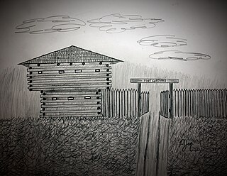
Fort Gardiner was a stockaded fortification with two blockhouses that was built in 1837 by the United States Army. It was one of the military outposts created during the Second Seminole War to assist Colonel Zachary Taylor's troops to capture Seminole Indians and their allies in the central part of the Florida Territory that were resisting forced removal to federal territory west of the Mississippi River per the Indian Removal Act.

Fort Basinger's original site is located approximately 35 miles (56 km) west of Fort Pierce, Florida, along U. S. Highway 98 in Highlands County, Florida. It was a stockaded fortification with two blockhouses that was built in 1837 by the United States Army. It was one of the military outposts created during the Second Seminole War to assist Colonel Zachary Taylor's troops to confront and capture Seminole Indians and their allies in the central part of the Florida Territory in the Lake Okeechobee region. The Seminole Indians and their allies were resisting forced removal to federal territory west of the Mississippi River as directed by the Indian Removal Act.
Gad Humphreys was an officer in the United States Army and an Indian agent in Florida. He was appointed to his post in 1822. He was supportive of the Indians and tried to help them and protect them from encroachments by White settlers. He was accused of abusing his post by preventing or delaying the return to their owners of fugitive slaves that had taken refuge with the Indians. An investigation was conducted, but none of his accusers were willing to testify. Even so, he was removed from his post in 1830.

The historic communities of Alachua County were populated places and/or places with a post office that were established in the 19th century or early 20th century in what is now Alachua County, Florida, but which were abandoned, annexed into an incorporated municipality, or had a much reduced population by the later part of the 20th century.