
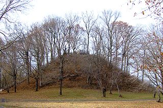
Effigy Mounds National Monument preserves more than 200 prehistoric mounds built by pre-Columbian Mound Builder cultures, mostly in the first millennium AD, during the later part of the Woodland period of pre-Columbian North America. Numerous effigy mounds are shaped like animals, including bears and birds.

The Hill of Tara is a hill and ancient ceremonial and burial site near Skryne in County Meath, Ireland. Tradition identifies the hill as the inauguration place and seat of the High Kings of Ireland; it also appears in Irish mythology. Tara consists of numerous monuments and earthworks—dating from the Neolithic to the Iron Age—including a passage tomb, burial mounds, round enclosures, a standing stone, and a ceremonial avenue. There is also a church and graveyard on the hill. Tara forms part of a larger ancient landscape and Tara itself is a protected national monument under the care of the Office of Public Works, an agency of the Irish Government.
The Pinson Mounds comprise a prehistoric Native American complex located in Madison County, Tennessee, in the region that is known as the Eastern Woodlands. The complex, which includes 17 mounds, an earthen geometric enclosure, and numerous habitation areas, was most likely built during the Middle Woodland period. The complex is the largest group of Middle Woodland mounds in the United States. Sauls' Mound, at 72 feet (22 m), is the second-highest surviving mound in the United States.

The Kolomoki Mounds is one of the largest and earliest Woodland period earthwork mound complexes in the Southeastern United States and is the largest in Georgia. Constructed from 350CE to 600CE, the mound complex is located in southwest Georgia, in present-day Early County near the Chattahoochee River.
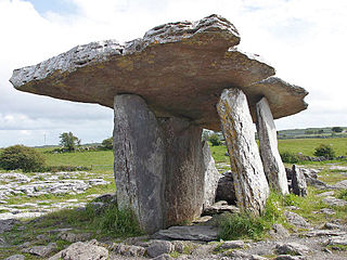
Poulnabrone dolmen is an unusually large dolmen or portal tomb located in the Burren, County Clare, Ireland. Situated on one of the most desolate and highest points of the region, it comprises three standing portal stones supporting a heavy horizontal capstone, and dates to the Neolithic period, probably between 4200 BC and 2900 BC. It is the best known and most widely photographed of the approximately 172 dolmens in Ireland.

The Swift Creek culture was a Middle Woodland period archaeological culture in the Southeastern Woodlands of North America, dating to around 100-800 CE. It occupied the areas now part of Georgia, Alabama, Florida, South Carolina, and Tennessee. In Florida, Swift Creek ceremonial practices and burial complexes are referred to technically as the Yent-Green Point complex. The Swift Creek culture was contemporaneous with and interacted with the Hopewell culture; Swift Creek is often described as "Hopewellian." The type site for the Swift Creek culture was the Swift Creek mound site, which was located in Bibb County, Georgia. The Leake Mounds are another significant Swift Creek Culture site in Georgia.

An effigy mound is a raised pile of earth built in the shape of a stylized animal, symbol, religious figure, human, or other figure. The Effigy Moundbuilder culture is primarily associated with the years 550-1200 CE during the Late Woodland Period, although radiocarbon dating has placed the origin of certain mounds as far back as 320 BCE.

Brownshill Dolmen is a very large megalithic portal tomb situated 3 km east of Carlow, in County Carlow, Ireland. Its capstone weighs an estimated 150 metric tons, and is reputed to be the heaviest in Europe. The tomb is listed as a National Monument. Known as the Kernanstown Cromlech, sometimes spelled as Browneshill Dolmen, it is sited on the former estate house of the Browne family from which it takes its name.

In archaeology, earthworks are artificial changes in land level, typically made from piles of artificially placed or sculpted rocks and soil. Earthworks can themselves be archaeological features, or they can show features beneath the surface.

The Carl Potter Mound is a historic Native American mound in southern Champaign County, Ohio, United States. Located near Mechanicsburg, it lies on a small ridge in a pasture field in southeastern Union Township. In 1974, the mound was listed on the National Register of Historic Places as a potential archaeological site, primarily because of its use as a burial mound.
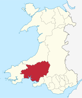
Carmarthenshire is a large rural county in West Wales. It includes a mix of upland and mountainous terrain and fertile farmland. The western end of the Brecon Beacons National Park lies within the county. Across Carmarthenshire there are a total of 370 scheduled monuments. That is too many to have on a single list page, so for convenience, the list is divided into the 227 prehistoric sites and the 143 Roman, Medieval and Post Medieval sites.

Ceredigion is a large rural county in West Wales. It has a long coastline of Cardigan Bay to the west and the remote moorland of the Cambrian Mountains in the east, with the mountainous terrain of Plynlimon in the northeast. Ceredigion has a total of 264 scheduled monuments. That is too many to have on a single list page, so for convenience the list is divided into two, 163 prehistoric sites and 101 Roman, Medieval and Post Medieval sites.

Powys is the largest administrative county in Wales. With over a quarter of Wales's land area, covering much of the eastern half of the country, it is a county of remote uplands, low population and no coastline. It was created in more or less its current form in 1974, and is the only one of the large county units created at that time to have been carried forward intact at the 1996 local government re-organisation. It comprises three historic counties, namely Montgomeryshire, Radnorshire, and most of Brecknockshire. There are 950 scheduled monuments within the county. This is far more than can be sensibly covered in one list, so each of the 3 historic counties is therefore listed separately, and each of these has two lists - one for the prehistoric sites and one for the Roman, medieval and post-medieval sites.

Rathgall, or the Ring of the Rath is a large multivallate hill fort near the town of Shillelagh. Dating from the Bronze Age, it consists of three roughly concentric stone ramparts with a fourth masonry wall dating from the Medieval period at its centre. Rathgall is a National Monument which is in state care.
The Orwell Site, designated 21OT7 in the state archaeological inventory, is a historic site located near Fergus Falls, Minnesota, United States. It consists of twelve Middle or Late Woodland period burial mounds, four of which are enclosed by an earthwork. They were built from about A.D. 350–600. They share similarities with the mounds found at Fort Juelson, also in Otter Tail County, with their central burial chamber. The site was listed on the National Register of Historic Places in 1974.
Ballon Hill is a bronze age hilltop enclosure encompassing burial grounds located near the village of Ballon, County Carlow.
Joseph Raftery was an Irish archaeologist and director of the National Museum of Ireland.

The Hartley Mound is a Native American burial mound in Columbus, Ohio. The mound was created around 2,000 years ago by the Pre-Columbian Native American Adena culture. The site was added to the National Register of Historic Places in 1974. The mound measures 2 ft. high and 43 ft. in diameter. The site's location near a tributary to a major waterway, artifacts found nearby, and the small subconical form of the mound, suggests that it was built by the Adena culture. It is one of few mounds not seriously disturbed by agriculture, industry, or illegal excavation. Upon archaeological excavation, the site should provide information on Adena burial customs and domestic or mortuary structures.
