Related Research Articles

Chiricahua is a band of Apache Native Americans.
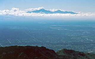
Sky islands are isolated mountains surrounded by radically different lowland environments. The term originally referred to those found near the southern borders of the U.S. states of Arizona and New Mexico with the northern borders of the Mexican States of Chihuahua and Sonora, and has extended to similarly isolated high-altitude forests. The isolation has significant implications for these natural habitats. The American Southwest region began warming up between ∼20,000–10,000 years BP and atmospheric temperatures increased substantially, resulting in the formation of vast deserts that isolated the sky islands. Endemism, altitudinal migration, and relict populations are some of the natural phenomena to be found on sky islands.

The Guadalupe River mainstem is an urban, northward flowing 14 miles (23 km) river in California whose much longer headwater creeks originate in the Santa Cruz Mountains. The river mainstem now begins on the Santa Clara Valley floor when Los Alamitos Creek exits Lake Almaden and joins Guadalupe Creek just downstream of Coleman Road in San Jose, California. From here it flows north through San Jose, where it receives Los Gatos Creek, a major tributary. The Guadalupe River serves as the eastern boundary of the City of Santa Clara and the western boundary of Alviso, and after coursing through San José, it empties into south San Francisco Bay at the Alviso Slough.

The North American beaver is one of two extant beaver species, along with the Eurasian beaver. It is native to North America and introduced in South America (Patagonia) and Europe. In the United States and Canada, the species is often referred to simply as "beaver", though this causes some confusion because another distantly related rodent, Aplodontia rufa, is often called the "mountain beaver". Other vernacular names, including American beaver and Canadian beaver, distinguish this species from the other extant beaver species, Castor fiber, which is native to Eurasia. The North American beaver is one of the official national wildlife of Canada symbols and is the official state mammal of Oregon and New York.
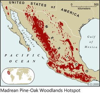
The Madrean pine–oak woodlands are subtropical woodlands found in the mountains of Mexico and the southwestern United States. They are a biogeographic region of the tropical and subtropical coniferous forests and temperate broadleaf and mixed forests biomes, located in North America.

The Yaqui River is a river in the state of Sonora in northwestern Mexico. It was formerly known as the Rio del Norte. Being the largest river system in the state of Sonora, the Yaqui river is used for irrigation, especially in the Valle del Yaqui.

The Sierra Madre Occidental pine–oak forests are a Temperate broadleaf and mixed forests ecoregion of the Sierra Madre Occidental range from the southwest USA region to the western part of Mexico. They are home to a large number of endemic plants and important habitat for wildlife.

Bavispe is a small town and a municipality in the northeast part of the Mexican state of Sonora.

The San Pedro River is a northward-flowing stream originating about 10 miles (16 km) south of the international border south of Sierra Vista, Arizona, in Cananea Municipality, Sonora, Mexico. The river starts at the confluence of other streams just east of Sauceda, Cananea. Within Arizona, the river flows 140 miles (230 km) north through Cochise County, Pima County, Graham County, and Pinal County to its confluence with the Gila River, at Winkelman, Arizona. It is the last major, undammed desert river in the American Southwest, and it is of major ecological importance as it hosts two-thirds of the avian diversity in the United States, including 100 species of breeding birds and almost 300 species of migrating birds.

The Rio San Bernardino, or San Bernardino River, begins in extreme southeastern Cochise County, Arizona, and is a tributary of the Bavispe River, in Sonora, Mexico.

Río Sonora is a 402-kilometer-long river of Mexico. It lies on the Pacific slope of the Mexican state of Sonora and it runs into the Gulf of California.
The Sierra San Luis range is a mountain range in northwest Chihuahua, northeast Sonora, Mexico at the northern region of the Sierra Madre Occidental cordillera. The region contains sky island mountain ranges, called the Madrean Sky Islands, some separated from the Sierra Madre Occidental proper, and occurring in the northeastern Sonoran Desert, and extreme west-northwestern Chihuahuan Desert. Many of the ranges occur in southeast Arizona.
Sierra del Tigre is a mountain range in northeastern Sonora, Mexico at the northern region of the Sierra Madre Occidental. The region contains sky island mountain ranges, called the Madrean Sky Islands, some separated from the Sierra Madre Occidental proper, and occurring in the northeastern Sonoran Desert, and extreme west-northwestern Chihuahuan Desert. Many of the ranges occur in southeast Arizona.

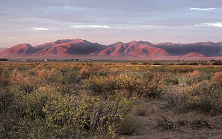
The San Bernardino Valley of Arizona is a 35 mi (56 km) northeast-by-southwest trending valley in extreme southeast Cochise County, Arizona. The north end of the valley merges into the northwest-by-southeast trending San Simon Valley; both merge in western perimeter Hidaldgo County, New Mexico. The valley is an asymmetric graben.

The Animas Valley is a lengthy and narrow, north–south 85 mi (137 km) long, valley located in western Hidalgo County, New Mexico in the Bootheel Region; the extreme south of the valley lies in Sonora-Chihuahua, in the extreme northwest of the Chihuahuan Desert, the large desert region of the north-central Mexican Plateau and the Rio Grande valley and river system.
Whitewater Draw, originally Rio de Agua Prieta, [Spanish: river of dark water], is a tributary stream of the Rio de Agua Prieta in Cochise County, Arizona. It was called Blackwater Creek by Philip St. George Cooke when his command, the Mormon Battalion, camped at a spring on its course on December 5, 1846.
Bavispe Flora and Fauna Protection Area is a protected area in the state of Sonora in northwestern Mexico.
References
- ↑ Leonard F. DeBano, ed. (1999). Biodiversity and the Management of the Madrean Archipelago: The Sky Islands of Southwestern United States and Northwestern Mexico. DIANE Publishing. p. 374. ISBN 978-0-7881-8386-7 . Retrieved 2011-11-24.
- 1 2 "Rio Bavispe". Wild Sonora. Archived from the original on 2011-10-07. Retrieved 2011-11-24.
- 1 2 3 Leonard F. DeBano, ed. (1999). Biodiversity and the Management of the Madrean Archipelago: The Sky Islands of Southwestern United States and Northwestern Mexico. DIANE Publishing. p. 374. ISBN 978-0-7881-8386-7 . Retrieved 2011-11-24.
- ↑ Juan-Pablo Gallo-Reynoso; Gabriela Suarez-Gracida; Horacia Cabrera-Santiago; Else Coria-Galindo; Janitzio Egido-Villarreal & Leo C. Ortiz (Sep 2002). "Status of Beavers (Castor Canadensis Frontador) in Rio Bavispe, Sonora, Mexico". The Southwestern Naturalist. Retrieved 2011-11-25.
- Atlas of Mexico, 1975 (http://www.lib.utexas.edu/maps/atlas_mexico/river_basins.jpg)%5B%5D.
- The Prentice Hall American World Atlas, 1984.
- Rand McNally, The New International Atlas, 1993.
%5B%5D)
| | This article related to a river in Mexico is a stub. You can help Wikipedia by expanding it. |