Related Research Articles
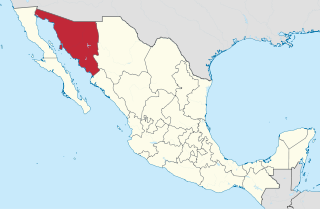
Sonora, officially Estado Libre y Soberano de Sonora, is one of the 31 states which, along with Mexico City, comprise the Federal Entities of Mexico. The state is divided into 72 municipalities; the capital city of which being Hermosillo, located in the center of the state. Other large cities include Ciudad Obregón, Nogales, San Luis Río Colorado, and Navojoa.

The Yaqui, Hiaki, or Yoeme, are an Indigenous people of Mexico and Native American tribe, who speak the Yaqui language, a Uto-Aztecan language.

The Sonoran Desert is a hot desert in North America and ecoregion that covers the northwestern Mexican states of Sonora, Baja California, and Baja California Sur, as well as part of the southwestern United States. It is the hottest desert in both Mexico and the United States. It has an area of 260,000 square kilometers (100,000 sq mi).

Ciudad Obregón is a city in southern Sonora. It is the state's second largest city after Hermosillo and serves as the municipal seat of Cajeme. As of 2020, the city has a population of 436,484. Ciudad Obregón is 530 km (330 mi) south of the state's northern border.

The Sierra Madre Occidental is a major mountain range system of the North American Cordillera, that runs northwest–southeast through northwestern and western Mexico, and along the Gulf of California. The Sierra Madre is part of the American Cordillera, a chain of mountain ranges (cordillera) that consist of an almost continuous sequence that form the western "sounds" of North America, Central America, South America, and West Antarctica.
The Opata are an indigenous people in Mexico. Opata territory, the "Opatería" in Spanish, encompasses the mountainous northeast and central part of the state of Sonora, extending to near the border with the United States. Historically, they included several subtribes, including the Eudeve, Teguima, and Jova peoples.

The Yaqui River is a river in the state of Sonora in northwestern Mexico. It was formerly known as the Rio del Norte. Being the largest river system in the state of Sonora, the Yaqui river is used for irrigation, especially in the Valle del Yaqui.

Federal Highway 15 is Mexico 15 International Highway or Mexico-Nogales Highway, is a primary north–south highway, and is a free part of the federal highways corridors of Mexico. The highway begins in the north at the Mexico–United States border at the Nogales Port of Entry in Nogales, Sonora, and terminates to the south in Mexico City.
Bacanora is a small town in Bacanora Municipality in the east of the Mexican state of Sonora. It is located at the geographical coordinates of 28°59′N109°24′W.
Ures is a small city and a municipality in the Mexican state of Sonora.

Ictalurus pricei, the Yaqui catfish, is a species of North American freshwater catfish native to Mexico and Arizona.
The Rio San Bernardino, or San Bernardino River, begins in extreme southeastern Cochise County, Arizona, and is a tributary of the Bavispe River, in Sonora, Mexico.
The Rio Bavispe or Bavispe River is a river in Mexico which flows briefly north then mainly south by southwest until it joins with the Aros River to become the Yaqui River, eventually joining the Gulf of California.

The San Bernardino National Wildlife Refuge is located on the U.S.-Mexico border in Cochise County, Arizona. Situated at 3,720 to 3,920 feet (1,130–1,190 m) elevation in the bottom of a wide valley, the refuge encompasses a portion of the headwaters of the Yaqui River, which drains primarily western Chihuahua and eastern Sonora, Mexico. The 2,309-acre (9.34 km2) ranch was acquired by the U.S. Fish and Wildlife Service in 1982 to protect the water resources and provide habitat for endangered native fishes.
The Yaqui longfin dace is a small fish of the American Southwest and northern Mexico, and considered a form of the longfin dace. It is often referred to as Agosia chrysogaster sp 1.

The Sulphur Springs Valley is a valley in the eastern half of Cochise County, Arizona. The valley covers an approximated vertical rectangle west of the Chiricahua Mountains–Dos Cabezas Mountains complex. The Sulphur Springs Valley is the large flatland to the west.

The Sonoran–Sinaloan transition subtropical dry forest is a tropical dry broadleaf forest ecoregion in northwestern Mexico.

The Animas Valley is a lengthy and narrow north–south valley 85 miles long, located in western Hidalgo County, New Mexico in the Bootheel Region; the extreme south of the valley lies in Sonora-Chihuahua, in the extreme north-west of the Chihuahuan Desert, the large desert region of the north-central Mexican Plateau and the Rio Grande valley and river system.
Bavispe Flora and Fauna Protection Area is a protected area in the state of Sonora in northwestern Mexico.
References
- 1 2 O’Brien, Chris; D. Flesch, Aaron; Wallace, Eric; Bogan, Michael; E. Carrillo-Percástegui, Samia; Jacobs, Sky; van Riper III, Charles (2006). "BIOLOGICAL INVENTORY OF THE RÍO AROS, SONORA, MEXICO: A RIVER UNKNOWN" (PDF). Aaron Flesch. Archived (PDF) from the original on April 11, 2024. Retrieved April 11, 2024.
- ↑ Flesch, Aaron D.; Warshall, Peter; Jacobs, Sky (2015). "Avian Richness, Status, and Conservation in the Northwestern Neotropics in Sonora, Mexico". Natural Areas Journal. 35 (2): 288–296. ISSN 0885-8608.
- Atlas of Mexico, 1975 (http://www.lib.utexas.edu/maps/atlas_mexico/river_basins.jpg).
- The Prentice Hall American World Atlas, 1984.
- Rand McNally, The New International Atlas, 1993.
| | This article related to a river in Mexico is a stub. You can help Wikipedia by expanding it. |