
The Nullarbor Plain is part of the area of flat, almost treeless, arid or semi-arid country of southern Australia, located on the Great Australian Bight coast with the Great Victoria Desert to its north. It is the world's largest single exposure of limestone bedrock, and occupies an area of about 200,000 square kilometres (77,000 sq mi). At its widest point, it stretches about 1,100 kilometres (684 mi) from east to west across the border between South Australia and Western Australia.

The Great Australian Bight is a large oceanic bight, or open bay, off the central and western portions of the southern coastline of mainland Australia.
Caiguna is a small roadhouse community located on the Eyre Highway in Western Australia. It is the second stop east of Norseman on the journey east across the Nullarbor Plain. Between Balladonia and Caiguna is a 146.6-kilometre (91.1 mi) stretch of the highway which is one of the longest straight stretches of road in the world. The unofficial Central Western Time (CWT) starts shortly east of Caiguna, heading eastward.

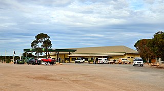
Cocklebiddy is a small roadhouse community located on the Eyre Highway in Western Australia. It is the third stop after Norseman on the journey eastwards across the Nullarbor Plain. Like other locations in the region, the site consists of little more than a roadhouse. The current business name of the roadhouse is the Wedgetail Inn and, like most other Nullarbor establishments, has access to satellite television, as well as providing caravan park and hotel-motel facilities.

Banksia epica is a shrub that grows on the south coast of Western Australia. A spreading bush with wedge-shaped serrated leaves and large creamy-yellow flower spikes, it grows up to 3½ metres (11½ ft) high. It is known only from two isolated populations in the remote southeast of the state, near the western edge of the Great Australian Bight. Both populations occur among coastal heath on cliff-top dunes of siliceous sand.
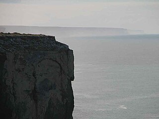
Point Culver is a headland on the south coast of Western Australia. It is located at 32° 54' S 124° 41' E, near the western end of the Great Australian Bight. The point marks the western end of the Baxter Cliffs, which extend eastwards for nearly 200 km along the coast.

Toolinna Cove is a cove on the south coast of Western Australia. It is a sea-cove along the Baxter Cliffs at the western end of the Great Australian Bight, in Nuytsland Nature Reserve. It is the only place between Point Culver and Twilight Cove where a boat can be landed.
Nuytsland Nature Reserve is a protected area of Western Australia in the south-eastern part of the state, on the south coast.
Toolinna Rockhole is a rockhole on the Nullarbor Plain in southern Western Australia. The explorer Edward John Eyre is thought to have visited it on 2 May 1842, but found it empty.

Hampton is an interim Australian bioregion located in southeastern coastal Western Australia, with a small portion (4%) extending into adjacent South Australia. It has an area of 1,088,198 hectares. The Hampton bioregion is part of the Coolgardie woodlands ecoregion.
The Bunda Cliffs, also known as the Nullarbor Cliffs, are a coastal scarp on the southern coast of Australia, extending from the western coast of South Australia to the south-eastern corner of Western Australia.
Adenanthos eyrei is a species of shrub in the family Proteaceae. Restricted to a single cliff-top dune system on the remote south coast of Western Australia, it is listed as rare and endangered. It was discovered by E. Charles Nelson in 1973, and formally described and named in 1978.
Prince Frederick Harbour lies at the southern end of the York Sound, in the Kimberley region of Western Australia, opening into the Indian Ocean.

Becher Point is the southernmost point of Warnbro Sound in Port Kennedy in Western Australia. It was the site of multiple ship beachings. It is a reference point for the adjacent Ramsar Becher Point Wetlands that lie inland from the point. It offers significant conservation value. It has been identified as a site for assessing Holocene environment on the coastline. As a place name, Port Kennedy is the name of a locality that is found where Becher point is, however Port Kennedy is not a notable coastal feature.
Cape Clairault is located south of Yallingup in the coastal region between Cape Naturaliste and Cape Leeuwin.
In South Australia, one of the states of Australia, there are many areas which are commonly known by regional names. Regions are areas that share similar characteristics. These characteristics may be natural such as the Murray River, the coastline, desert or mountains. Alternatively, the characteristics may be cultural, such as common land use. South Australia is divided by numerous sets of regional boundaries, based on different characteristics. In many cases boundaries defined by different agencies are coterminous.
Burnside Island lies on the eastern side of Exmouth Gulf on the coast of Western Australia.

The Roe Plains is a coastal plain in the southeastern corner of Western Australia.
Twilight Cove is situated at the end of the Baxter Cliffs on the south coast of Western Australia on the Great Australian Bight coastline. It has had other names, including Malbinya.
Wilson Bluff is a coastal cliff on the Australian continental coastline, extending from east of Eucla in Western Australia to south of Border Village in South Australia. It was first recorded in 1885 as Wilson Point, but was Wilson Bluff in volume one of the Australian Pilot 1914–1918 edition. It is reported as being named after "Professor Wilson of Victoria" by E. A. Delisser, a surveyor employed by DeGraves and Co., a pastoral company.
