
The Nullarbor Plain is part of the area of flat, almost treeless, arid or semi-arid country of southern Australia, located on the Great Australian Bight coast with the Great Victoria Desert to its north. It is the world's largest single exposure of limestone bedrock, and occupies an area of about 200,000 square kilometres (77,000 sq mi). At its widest point, it stretches about 1,100 kilometres (684 mi) from east to west across the border between South Australia and Western Australia.

The Great Australian Bight is a large oceanic bight, or open bay, off the central and western portions of the southern coastline of mainland Australia.

Eyre Highway is a 1,660-kilometre (1,030 mi) highway linking Western Australia and South Australia via the Nullarbor Plain. Signed as National Highways 1 and A1, it forms part of Highway 1 and the Australian National Highway network linking Perth and Adelaide. It was named after explorer Edward John Eyre, who was the first European to cross the Nullarbor by land, in 1840–1841. Eyre Highway runs from Norseman in Western Australia, past Eucla, to the state border. Continuing to the South Australian town of Ceduna, it then crosses the top of the Eyre Peninsula before reaching Port Augusta.

Eucla is the easternmost locality in Western Australia, located in the Goldfields-Esperance region of Western Australia along the Eyre Highway, approximately 11 kilometres (7 mi) west of the South Australian border. At the 2016 Australian census, Eucla had a population of 53.
John Baxter was an Irish convict who became an Australian pioneer, overlander, explorer, and offsider of explorer Edward John Eyre.

Mundrabilla is in a very sparsely populated area in the far south east of Western Australia. The two significant features are Mundrabilla Roadhouse and Mundrabilla Station, which are approximately 35 kilometres (22 mi) apart. At the 2016 census, Mundrabilla had a population of 23, 32% male and 68% female. The time zone in use is UTC+08:45.
The Eucla Basin is an artesian depression located in Western Australia and South Australia. The onshore-offshore depression covers approximately 1,141,000 km² and slopes southward to an open bay known as the Great Australian Bight.

Eyre Bird Observatory is an educational, scientific and recreational facility in the Nuytsland Nature Reserve, Western Australia. Cocklebiddy is the nearest locality on the Eyre Highway, 49 km (30 mi) to the north. It is in the Hampton bioregion, which is sandwiched between the Nullarbor Plain to the north and the Great Australian Bight to the south, in one of the least populated places on the Australian continent. It was established in 1977 by Birds Australia in the disused Eyre Telegraph Station as Australia's first bird observatory, to provide a base for the study and enjoyment of the birds of the area.

Madura is a small roadhouse community located on the Eyre Highway in Western Australia, on the Roe Plains. It is 1,253 kilometres (779 mi) from Perth. It is at the foot of the escarpment next to the Madura Pass down from the Nullarbor Plain. UTC+8:45 is the local time zone in use.

Nuytsland Nature Reserve is a protected area of Western Australia in the south-eastern part of the state, on the south coast.

Hampton is an interim Australian bioregion located in southeastern coastal Western Australia, with a small portion (4%) extending into adjacent South Australia. It has an area of 1,088,198 hectares. The Hampton bioregion is part of the Coolgardie woodlands ecoregion.
The Mirning, also known as the Ngandatha, are an Aboriginal Australian people whose traditional lands lay on the coastal region of the Great Australian Bight extending from Western Australia into south-west South Australia.
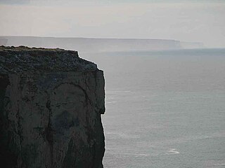
The Bunda cliffs are part of a larger scarp of the Eucla Basin that spreads from the western part of South Australia across to the south eastern corner of Western Australia. As a geographical feature, they form part of the longest uninterrupted line of sea cliffs in the world.

The Coolgardie woodlands is an ecoregion in southern Western Australia. The predominant vegetation is woodlands and mallee scrub. The ecoregion is a transitional zone between the Mediterranean-climate forests, woodlands, and shrublands of Southwest Australia and the deserts and dry scrublands of the Australian interior.

Nurina Land District is a land district of Western Australia, located within the Eucla Land Division on the Nullarbor Plain. It spans roughly 31°00'S - 32°20'S in latitude and 125°30'E - 127°30'E in longitude.
Mundrabilla Land District is a land district of Western Australia, located within the Eucla Land Division on the Nullarbor Plain. It spans roughly 31°00'S - 32°00'S in latitude and 127°30'E - 129°00'E in longitude.
Nuyts Land District is a land district of Western Australia, located within the Eastern and Eucla land divisions on the Nullarbor Plain. It spans roughly 31°00'S - 32°50'S in latitude and 124°00'E - 125°30'E in longitude.

Hampton Tableland is a feature that is found at the northern side of the current alignment of the Eyre Highway between Madura and Eucla in Western Australia, at the southern edge of the Nullarbor Plain.
Wilson Bluff is a coastal cliff on the Australian continental coastline, extending from east of Eucla in Western Australia to south of Border Village in South Australia. It was first recorded in 1885 as Wilson Point, but was Wilson Bluff in volume one of the Australian Pilot 1914–1918 edition. It is reported as being named after "Professor Wilson of Victoria" by E. A. Delisser, a surveyor employed by DeGraves and Co., a pastoral company.
The Baxter Cliffs is a long stretch of coastal cliff on the south coast of Western Australia.
