
Balmain is a suburb in the Inner West of Sydney, New South Wales, Australia. Balmain is located two kilometres west of the Sydney central business district, in the local government area of the Inner West Council.

Rozelle is a suburb in the inner west of Sydney, in the state of New South Wales, Australia. It is located 4 kilometres west of the Sydney central business district, in the local government area of the Inner West Council.

The Sydney College of the Arts (SCA) is a contemporary art school that was a faculty of the University of Sydney from 1990 until 2017, when it became a school of the Faculty of Arts and Social Sciences. Until the end of 2019, the campus was located in Rozelle, Sydney and housed within Callan Park in the Kirkbride complex, a cluster of sandstone buildings designed by James Barnet, the government architect, in the late 19th century. SCA moved to the main Camperdown Campus of the University of Sydney in 2020 and now occupies a substantial portion of the Old Teachers' College.
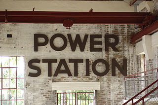
The Balmain Power Station was located at Iron Cove, 4 km (2 mi) from Sydney in New South Wales, Australia. The station no longer exists and residential properties now occupy the site. This plant is often confused with the White Bay Power Station, the remains of which are still standing in Rozelle.

White Bay is a bay on Sydney Harbour with a surrounding locality near the suburbs of Balmain and Rozelle in the Inner West of Sydney, New South Wales, Australia.

The Iron Cove Bridge is a heritage-listed road bridge that carries Victoria Road (A40) across Iron Cove, between the Sydney suburbs of Drummoyne and Rozelle. Iron Cove is an arm of Sydney Harbour.
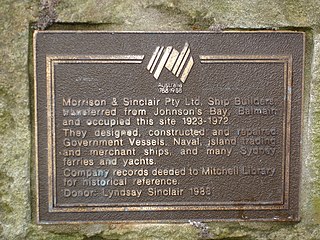
Morrison & Sinclair was a Sydney, New South Wales based company and one of the great ship and boatbuilding names of Port Jackson. The company was founded in the early 1890s and ceased trading in 1970.

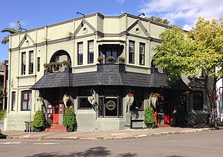
The Bald Rock Hotel is a heritage-listed pub in the suburb of Rozelle, overlooking White Bay in the inner west region of Sydney, in the state of New South Wales, Australia. It is the oldest continuously licensed hotel still operating in the Balmain and Rozelle area.

The Forth & Clyde Hotel is a former pub located in Balmain, a suburb in the inner west region of Sydney, in the state of New South Wales, Australia. The former pub was one of a number of buildings which formed an integral part of the shipbuilding and industrial heritage of the local area.

The Volunteer Hotel was a pub in the suburb of Balmain in the Inner West of Sydney, in the state of New South Wales, Australia.

Balmain is an electoral district of the Legislative Assembly of the Australian state of New South Wales in Sydney's Inner West. It is currently represented by Kobi Shetty of the Greens.
The Riverview Hotel is a heritage-listed pub located in Balmain, a suburb in the inner west region of Sydney, in the state of New South Wales, Australia. Australian swimming champion, Dawn Fraser, was publican of the Riverview from 1978 to 1983.

The Shipwright's Arms is an historic de-licensed pub located in Balmain East, a suburb in the inner west region of Sydney, in the state of New South Wales, Australia. The former pub looks out across Sydney Harbour to the Sydney Harbour Bridge and currently houses luxury apartments.

The Albion Hotel is a former pub in the suburb of Balmain, in the Inner West of Sydney, in the state of New South Wales, Australia. It is currently operated as a trattoria, café and private residence.

The White Bay Hotel was a pub that operated between 1860 and 1992. The land has been acquired by the New South Wales Government after being destroyed by fire and demolished.

Dick's Hotel is a pub located in Balmain, a suburb in the inner west region of Sydney, in the state of New South Wales, Australia. The pub was built by John Dick, a local publican of note, in 1872 on the corner of Beattie and Montague Streets.

Glebe Island was a major port facility in Sydney Harbour and, in association with the adjacent White Bay facility, was the primary receiving venue for imported cars and dry bulk goods in the region until 2008. It is surrounded by White, Johnstons, and Rozelle Bays. Whilst retaining its original title as an "island", it has long been infilled to the shoreline of the suburb of Rozelle and connected by the Glebe Island Bridge to Pyrmont.

Inner West Council is a local government area located in the Inner West region of Sydney in the state of New South Wales, Australia. The Inner West LGA makes up the eastern part of this wider region, and was formed on 12 May 2016 from the merger of the former Ashfield, Leichhardt and Marrickville councils.

