Blorenge, also called The Blorenge, is a prominent mountain overlooking the valley of the River Usk in Abergavenny, Monmouthshire, southeast Wales. It is situated in the southeastern corner of the Brecon Beacons National Park. The summit plateau reaches a height of 1,841 feet (561 m).

Stybarrow Dodd is a mountain or fell in the English Lake District. It stands immediately north of Sticks Pass on the main ridge of the Helvellyn range in the Eastern Fells, which is situated between the lakes of Thirlmere and the Ullswater.

Fan Fawr is a mountain in the Fforest Fawr section of the Brecon Beacons National Park, in Powys, Wales and over 734 m (2,408 ft) high.

Pen Cerrig-calch is a subsidiary summit of Waun Fach in the Black Mountains in the Brecon Beacons National Park in southern Powys, Wales. Its summit, at a height of 701m (2,300 ft), is marked by a trig point. The peak sits high above the River Usk valley as it narrows above the small town of Crickhowell.The views from here are wide-ranging and extend as far as the Beacons themselves to the west. A ridge runs off to the northwest and the shoulder of Pen Gloch-y-pibwr then turns north to the secondary top of Pen Allt-mawr whose peak at 719m is also crowned by a trig point.

Fforest Fach is a small area of unenclosed land within Brecon Beacons National Park southwest of Sennybridge in the county of Powys, Wales. Translating from Welsh as 'little forest', it is named in opposition to the much larger area of unenclosed land to the south which is known as Fforest Fawr or the 'great forest'. Whilst Fforest Fawr and Fforest Fach have been distinct areas for many centuries, the odd situation now arises where Fforest Fach now finds itself within Fforest Fawr Geopark, the boundaries of which are drawn rather more widely than those of the traditional royal hunting forest.
The hill possesses two indistinct summits, the higher of which at 382m is in the south whilst that to the north at 381m is crowned by a trig point. There was formerly a rifle range at the north-western corner of the hill.
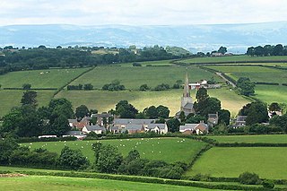
Ysgyryd Fach is a hill one mile east of Abergavenny in the county of Monmouthshire, south Wales. It is often referred to in English as 'Little Skirrid' or sometimes as 'Skirrid Fach'. Its summit height is just over 270m. A conifer plantation extends over much of the hill including its summit; prior to felling of trees on the upper slopes in 2012 outward views were therefore restricted. The hill is considered to be one of the 'seven hills of Abergavenny'.

The Grwyne Fawr is a river in the Brecon Beacons National Park in south Wales. A section of it forms the administrative border between Powys and Monmouthshire and also of the historic counties of Brecon and Monmouth. The river and its major tributary the Grwyne Fechan flow into the River Usk at Glangrwyney.
Penmoelallt or Onllwyn is a hill in the northern part of the county borough of Rhondda Cynon Taff in south Wales. It lies within the Brecon Beacons National Park and Fforest Fawr Geopark. To its east lies the deep valley of Cwm Taf and to its north a rather shallower valley in which the Nant Cadlan originates. To the west is the hill known as Mynydd-y-glog and to the south are slopes draining into the River Taff and the Afon Cynon. The hill culminates in a broken plateau with several knolls rising above the 420m contour. Its afforested nature makes it difficult to determine the precise location of its highest point but this probably lies somewhere around OS grid ref SO 003096. Older maps indicate a spot height of 1376 ft above sea level at SO 000090.

Carreg Dwfn is a hill four miles southeast of Llandeilo and just to the south of the village of Trap in the county of Carmarthenshire, south Wales. It lies at the western extremity of the Brecon Beacons National Park and Fforest Fawr Geopark. Its summit at 283 metres (928 ft) is towards the eastern end of a rocky east-west-aligned ridge.
Trichrug is a hill four miles east of Llandeilo and 3 miles south of Llangadog in the county of Carmarthenshire, southwest Wales. It lies within the Brecon Beacons National Park and Fforest Fawr Geopark. Its summit at a height of 415m above sea level is marked by a trig point. It is a Marilyn with a prominence of 191 metres.
Bryn Arw is a hill in the Black Mountains of the Brecon Beacons National Park in Monmouthshire, south Wales. It lies 4 km north of the town of Abergavenny and 1.5 miles west of the village of Llanvihangel Crucorney. Its summit at 384m above sea level is the more northerly of two tops which lie on the crest of a slightly arcuate north-south ridge which drops away to the south at first gently and then sharply. The hill is isolated from the main mass of the range by the valleys of Cwm Coed-y-cerig to the north and by Cwm Brynarw to the west. It is a Marilyn.
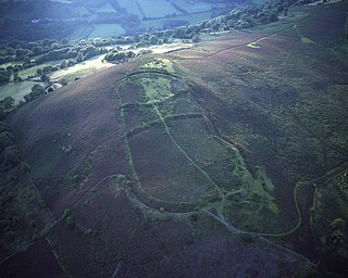
Gaer is the name of a hill in the Black Mountains of the Brecon Beacons National Park in Monmouthshire, south Wales. It lies at the southern end of the long ridge between the valley of the Grwyne Fawr and the Vale of Ewyas one mile to the north of Bryn Arw and 3 miles northeast of Sugarloaf. Its summit at 427m above sea level sits within an Iron Age hillfort known as Twyn y Gaer.
Mynydd Troed is a hill in the Black Mountains of the Brecon Beacons National Park in Powys, south Wales. Its name literally translates to "Foot Mountain," based how it appears when viewed from the Allt Mawr ridge.

Mynydd Llangorse is a hill on the western edge of the Black Mountains in the Brecon Beacons National Park in Powys, south Wales. It lies two miles east of Llangors and its lake and 5 miles south of Talgarth. Its summit at 515m overtops the location 600m to the south at which a trig point is sited by 9m. The broad spur of Cefn Moel extends south towards the village of Bwlch whilst a spur to the southeast forms Pen Tir which reaches just over 450m above sea level. It is a Marilyn with a prominence of 161 metres.

Mynydd Merthyr is a broad ridge of high ground between Taff Vale and the Cwm Cynon in the Valleys region of South Wales. It forms the boundary between the unitary authorities of Rhondda Cynon Taff to the west and Merthyr Tydfil to the east.
Bosley Minn is one of two names – the other being Wincle Minn – given to a prominent hill in southeast Cheshire and in the southwestern corner of the Peak District National Park in northern England. The long axis of the Minn runs NNE–SSW and its broad summit, which reaches to 386 metres (1,266 ft) at its highest point, slopes away to the valley of the Shell Brook in the east and towards Bosley Reservoir in the west. It is the western aspect of the hill, facing Bosley which is known as Bosley Minn whilst the eastern side which faces the village of Wincle is referred to as Wincle Minn.

Pen-y-crug is a hill in the Brecon Beacons National Park in the county of Powys, south Wales. It is commonly referred to locally as simply 'The Crug'. The Welsh name signifies 'top of the mound'. It slopes are moderately gently on three sides; only to the west do they steepen somewhat. Its flat trig point adorned summit at 331m overlooks the valley of the River Usk to the south. To the southeast are panoramic views over Brecon whilst eastwards are the Black Mountains and south the Brecon Beacons.
Cefn Gwyngul is a long broad ridge to the east of the Rhondda Fach valley in Rhondda Cynon Taf County Borough in South Wales. Its 470m high summit is marked by an ancient cairn known as Carn-y-Pigwn, on which is a more recent trig point. Much of the hill is cloaked by modern forestry plantations though its southwestern flank between Porth and Ferndale has not been coniferised. The earthworks of a Roman camp remain on the ridge at OS grid ref ST 002982.

Mynydd William Meyrick is a 535-metre-high hill straddling the boundary of Bridgend and Rhondda Cynon Taf county boroughs between the valley of the Rhondda Fawr and Ogmore Valley in South Wales. It takes the form of a broad northwest-southeast ridge with numerous broad shoulders extending to the east, south and west, each of which have different names and some of which constitute minor tops. Listed clockwise from the north these are; Mynydd Maendy, Mynydd Ton, Mynydd Bwllfa, Mynydd Pwllyrhebog, Mynydd Maes-teg, Mynydd y Gwair and Mynydd yr Aber. The summit of the entire massif is often referred to as Mynydd Ton. Its western sides are open moorland whilst its eastern sides have been afforested by the Forestry Commission.
Mynydd Allt-y-grug is a 338-metre-high hill immediately west of Ystalyfera in the county borough of Neath Port Talbot in South Wales. Its twin summits are around 400m apart. The upper part of the hill is largely covered in heather whilst conifers clothe its western slopes and gorse, bracken and bramble cover much of its rough landslipped eastern side which rises above the Swansea Valley, drainage on this side flowing to the River Tawe.