Llandogo

Last updated

Llandogo
Llandogo.jpg
Llandogo viewed from across the River Wye
Monmouthshire UK location map.svg
Red pog.svg
Llandogo
Location within Monmouthshire
Population547 
OS grid reference SO525039
Community
Principal area
Preserved county
Country Wales
Sovereign state United Kingdom
Post town MONMOUTH
Postcode district NP25
Dialling code 01594
Police Gwent
Fire South Wales
Ambulance Welsh
UK Parliament
Senedd Cymru – Welsh Parliament
List of places
UK
Wales
Monmouthshire
51°43′54″N2°41′14″W / 51.7318°N 2.68715°W / 51.7318; -2.68715

Llandogo is a small village in Monmouthshire, south Wales, between Monmouth and Chepstow in the lower reaches of the Wye Valley AONB, two miles north of Tintern. It is set on a steep hillside overlooking the River Wye and across into the Forest of Dean in Gloucestershire, England. The 2011 census population was 547. [1]

Contents

History

Church of St Oudoceus Llandogo Monmouthshire Cymru Wales 04 (cropped).JPG
Church of St Oudoceus

The village derives its name from St Euddogwy (Oudoceus), the third Bishop of Llandaff, who is said to have lived in the area in the sixth or seventh century. [2] Llaneuddogwy, the historic form of the name, is still occasionally used, although Llandogo is the standard form in both Welsh and English. [3] The church was formerly also or alternatively dedicated to St Einion Frenin, who was credited with establishing St Cadfan's monastery on Bardsey Island off Llŷn. [4] The present church is on the site of a 7th or 8th-century foundation, but was wholly rebuilt in 1859–1861 by John Pollard Seddon. [5] [6] It has been described as one of Seddon's "most high-spirited small churches", with "polychromatic interplay inside and out" between mauve and ochre stone, and "an extraordinarily elaborate belfry". [7]

Llandogo was a port, renowned at one time for building of the trow, a flat-bottomed river boat that until the 19th century was used for trading up and down the River Wye, also on the River Severn shore and across the Severn Estuary and the Bristol Channel to Bristol. The boat gave its name to the historic Llandoger Trow pub close to the harbour in Bristol. The bell of The William and Sarah, one of the last Chepstow barges to trade on the river, can be found in the bell tower of the church at Llandogo.

The Priory is a villa built in 1838 for John Gough by the architects Wyatt & Brandon. [7] It is associated with Robert Baden-Powell, founder of the Scouting movement, who spent several summers as a boy there. He recounts in the sixth yarn of Scouting For Boys an expedition by folding boat up the River Thames, down the River Avon and across the Severn Estuary, finishing in Llandogo. The house belonged to Count Henry Philip Ducarel de la Pasture, [8] whose wife and daughter were both well-known novelists, as Mrs Henry de la Pasture and E. M. Delafield respectively.

Areas of interest

Llandogo with the Sloop Inn on the left. Llandogo Monmouthshire Cymru Wales 01.JPG
Llandogo with the Sloop Inn on the left.
Coloured lithograph by William Henry Bartlett, c. 1845 Landogo (3374942).jpg
Coloured lithograph by William Henry Bartlett, c. 1845

There are many local walks along the river bank and up through the village to Cleddon Shoots, a local Site of Special Scientific Interest and towards the village of Trellech. The Wye Valley Walk runs along the top of the village, and the Offa's Dyke walk is just across the river. The village is designated as a Conservation Area. [9]

The village hall, the Millennium Hall, was opened in 2003 by The Princess Royal. Events are organised by the local community.

Brown's Stores was the village's only general goods store since 1921 until it closed in 2021. The family itself have lived in the village for generations.

The Sloop Inn is the village's only public house and derives its name from the sloops that traded up and down the River Wye and across the Bristol Channel, being larger than the smaller, lighter flat bottomed trows.

Cleddon Shoots

Cleddon Shoots is an area of acidic woodland on the east facing slope of the valley above Llandogo. The main trees present are Sessile Oak, Beech, Ash and Alder.

Cleddon Falls

Cleddon Falls ( SO520039 ) is a waterfall that rises above the southwest of the village and runs eastwards down into the Wye Valley.

Railways

St Briavels railway station was a station along the Wye Valley Railway. It was built in 1876 during the construction of the line on the Monmouthshire side of the River Wye at Bigsweir, and was intended to serve the nearby villages of St Briavels, across the river in the Forest of Dean, and Llandogo, which is further down the Wye Valley. It was closed on 5 January 1959 when the line was closed to passenger services. St Briavels station was renamed three time during its life: firstly Bigsweir Station, then St Briavels and Llandogo Station, and finally St Briavels Station. [10] Eventually a new halt was provided. Llandogo Halt railway station was a request stop on the former Wye Valley Railway. It was opened on 7 March 1927 to serve the village of Llandogo. It was closed in 1959 following the withdrawal of passenger services on the line. It was the smallest construction on the Wye Valley Railway. [10]

Cultural references

Llandogo was a main filming site for the 2019 TV series Sex Education . [11]

Related Research Articles

<span class="mw-page-title-main">Chepstow</span> Town in Monmouthshire, Wales

Chepstow is a town and community in Monmouthshire, Wales, adjoining the border with Gloucestershire, England. It is located on the tidal River Wye, about 2 miles (3 km) above its confluence with the River Severn, and adjoining the western end of the Severn Bridge. It is the easternmost settlement in Wales, situated 16 miles (26 km) east of Newport, 28 miles (45 km) east-northeast of Cardiff, 18 miles (29 km) northwest of Bristol and 110 miles (180 km) west of London.

<span class="mw-page-title-main">Monmouthshire</span> County in Wales

Monmouthshire is a county in the south east of Wales. It borders Powys to the north; the English counties of Herefordshire and Gloucestershire to the north and east; the Severn Estuary to the south, and Torfaen, Newport and Blaenau Gwent to the west. The largest town is Abergavenny, and the administrative centre is Usk.

<span class="mw-page-title-main">Tintern</span> Village in Monmouthshire, Wales

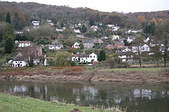
Tintern is a village in the community of Wye Valley, on the west bank of the River Wye in Monmouthshire, Wales, close to the border with England, about 5 miles (8.0 km) north of Chepstow. It is popular with tourists, in particular for the scenery and the ruined Tintern Abbey. Modern Tintern has been formed through the coalescence of two historic villages; Tintern Parva, forming the northern end of the village, and Chapel Hill, which forms the southern end. The village is designated as a Conservation Area.

<span class="mw-page-title-main">Trow</span> Type of British river cargo boat

A trow was a type of cargo boat found in the past on the rivers Severn and Wye in Great Britain and used to transport goods.

<span class="mw-page-title-main">Chepstow Castle</span> Castle in Chepstow, Monmouthshire, Wales

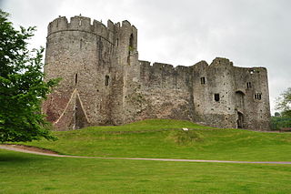
Chepstow Castle at Chepstow, Monmouthshire, Wales is the oldest surviving post-Roman stone fortification in Britain. Located above cliffs on the River Wye, construction began in 1067 under the instruction of the Norman Lord William FitzOsbern. Originally known as Striguil, it was the southernmost of a chain of castles built in the Welsh Marches, and with its attached lordship took the name of the adjoining market town in about the 14th century.

<span class="mw-page-title-main">Beachley</span> Human settlement in England

Beachley is a village in Gloucestershire, England, near the border with Monmouthshire, Wales. It is located on a peninsula at the confluence of the rivers Wye and Severn, where the Severn Bridge ends and the smaller secondary bridge over the River Wye begins, both bridges carrying the M48 motorway between England and Wales though the motorway is not directly accessible from the village. The tidal range on this stretch of water is the highest in the UK. Before the construction of the bridge it was a ferry port from where the Aust Ferry operated until 1966.The population in 2011 was 764.

<span class="mw-page-title-main">Tidenham</span> Human settlement in England

Tidenham is a village and civil parish in the Forest of Dean of west Gloucestershire, England, adjoining the Welsh border. Tidenham is bounded by the River Wye to the west and the River Severn to the south. Offa's Dyke runs through the western part of the parish, terminating at Sedbury cliff above the River Severn.

<span class="mw-page-title-main">St Briavels</span> Village and civil parish in Gloucestershire, England

St Briavels, is a medium-sized village and civil parish in the Royal Forest of Dean in west Gloucestershire, England; close to the England-Wales border, and 5 miles (8 km) south of Coleford. It stands almost 800 feet (240 m) above sea level on the edge of a limestone plateau above the valley of the River Wye, above an ancient meander of the river. To the west, Cinder Hill drops off sharply into the valley. It is sheltered behind the crumbling walls of the 12th century St Briavels Castle.

<span class="mw-page-title-main">Wye Valley</span> Area of Outstanding Natural Beauty in England and Wales

The Wye Valley National Landscape is an internationally important protected landscape straddling the border between England and Wales.

<span class="mw-page-title-main">A466 road</span> Road in England and Wales

The A466, also known as the Wye Valley Road, is a road from Hereford, England to Chepstow, Wales via Monmouth, Tintern and the Wye Valley.

<span class="mw-page-title-main">Portskewett</span> Village and community in Monmouthshire, Wales

Portskewett is a village and community (parish) in Monmouthshire, south east Wales. It is located four miles south west of Chepstow and one mile east of Caldicot, in an archaeologically sensitive part of the Caldicot Levels on the Welsh shore of the Severn Estuary. The Second Severn Crossing passes overhead carrying the M4 motorway. The community includes Sudbrook, Crick and Leechpool.

<span class="mw-page-title-main">Whitebrook</span> Human settlement in Wales

Whitebrook is a small village in Monmouthshire, south-east Wales, United Kingdom. It is located four miles south east of Monmouth in the Wye Valley.

<span class="mw-page-title-main">Brockweir</span> Human settlement in England

Brockweir is a village in Hewelsfield and Brockweir civil parish, in the Forest of Dean District of Gloucestershire, England. The civil parish also includes the separate village of Hewelsfield.

<span class="mw-page-title-main">Bigsweir Bridge</span> Bridge in Monmouthshire, Wales

Bigsweir Bridge is an 1827 road bridge crossing the River Wye, straddling the boundary between the parish of St. Briavels, Gloucestershire, England, and Llandogo, Monmouthshire, Wales.

<span class="mw-page-title-main">Wye Valley Railway</span> Disused railway in England and Wales

The Wye Valley Railway was a standard gauge railway that ran for nearly 15 miles (24 km) along the Lower Wye Valley between the towns of Chepstow and Monmouth, crossing several times between Wales and England. Opened on 1 November 1876, it was leased to, and worked by, the Great Western Railway (GWR), before being fully absorbed by the GWR in 1905.

<span class="mw-page-title-main">Penterry</span> Human settlement in Wales

Penterry is a small rural parish of 479 acres (1.94 km2) in Monmouthshire, Wales. It is located between the villages of St. Arvans and Tintern, about 4 miles (6.4 km) north of Chepstow, within the Wye Valley Area of Outstanding Natural Beauty and about 2 miles (3.2 km) from the border with England. It now contains an isolated parish church adjoining the site of a deserted village, and a few farms.

<span class="mw-page-title-main">England–Wales border</span> National boundary between England and Wales

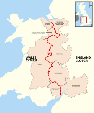
The England–Wales border, sometimes referred to as the Wales–England border or the Anglo-Welsh border, runs for 160 miles (260 km) from the Dee estuary, in the north, to the Severn estuary in the south, separating England and Wales.
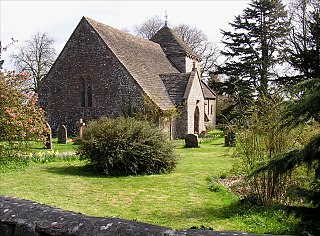
<span class="mw-page-title-main">St Briavels railway station</span> Former railway station in Wales

St Briavels Station was a station along the Wye Valley Railway. It was built in 1876 during the construction of the line on the Monmouthshire side of the River Wye at Bigsweir, and was intended to serve the nearby villages of St Briavels, across the river in the Forest of Dean, and Llandogo, which is further down the Wye Valley. It was closed on 5 January 1959 when the line was closed to passenger services.

<span class="mw-page-title-main">Church of St Oudoceus, Llandogo</span> Church in Monmouthshire, Wales

The Church of St Oudoceus, Llandogo, Monmouthshire is a parish church built in 1859–1861. The church is dedicated to St Oudoceus (Euddogwy), an early Bishop of Llandaff who retired to Llandogo and was reputed to have died there in about AD 700. Designed by the ecclesiastical architect John Pollard Seddon, the church has a notable painted interior. It is an active parish church and a Grade II* listed building.

<span class="mw-page-title-main">Portskewett Pier railway station</span> Former railway station in Wales

Portskewett Pier was a station on the Bristol & South Wales Union Railway. The pier at Black Rock, near Portskewett, was the Welsh side of the New Passage Ferry across the River Severn. The ferry linked rail services between Bristol and South Wales, avoiding the previous long detour through Gloucester. The ferry service lasted for nearly twenty five years, from 1863 to 1886, until the opening of the railway tunnel beneath the river.

References

  1. "Custom report - Nomis - Official Labour Market Statistics".
  2. Glamorgan-Gwent Archaeological Trust Historic Landscape Characterisation: Llandogo
  3. Welsh Language Commissioner. "List of Standardised Welsh Place-names" . Retrieved 31 March 2024.{{cite web}}: CS1 maint: url-status (link)
  4. Baring-Gould, Sabine & al. The Lives of the British Saints: The Saints of Wales and Cornwall and Such Irish Saints as Have Dedications in Britain, Vol. II, pp. 422 ff. Chas. Clark (London), 1908. Hosted at Archive.org. Accessed 18 Nov 2014.
  5. "Lower Wye Valley HLCA024".
  6. "Artworks at Church of St Oudoceus, Llandogo, Monmouthshire in the Imaging the Bible in Wales database".
  7. 1 2 Newman, John (2000). The Buildings of Wales: Gwent/Monmouthshire. Penguin Books. pp. 274–275. ISBN   0-14-071053-1.
  8. "Priory Care Home". Archived from the original on 3 June 2011. Retrieved 28 February 2010.
  9. Adopted Unitary Development Plan Archived 12 July 2010 at the Wayback Machine
  10. 1 2 B. M. Handley and R. Dingwall, The Wye Valley Railway and the Coleford Branch, 1982, ISBN   0-85361-530-6
  11. Medd, James (22 January 2019). "Where is 'Sex Education' on Netflix filmed?". Condé Nast Traveller . Retrieved 22 January 2019.