
Tierra del Fuego is an archipelago off the southernmost tip of the South American mainland, across the Strait of Magellan.
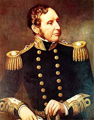
Vice-Admiral Robert FitzRoy was an English officer of the Royal Navy, politician and scientist who served as the second Governor of New Zealand between 1843 to 1845. He achieved lasting fame as the captain of HMS Beagle during Charles Darwin's famous voyage, FitzRoy's second expedition to Tierra del Fuego and the Southern Cone.

Darwin's finches are a group of about 18 species of passerine birds. They are well known for their remarkable diversity in beak form and function. They are often classified as the subfamily Geospizinae or tribe Geospizini. They belong to the tanager family and are not closely related to the true finches. The closest known relative of the Galápagos finches is the South American dull-coloured grassquit. They were first collected when the second voyage of the Beagle visited the Galápagos Islands, with Charles Darwin on board as a gentleman naturalist. Apart from the Cocos finch, which is from Cocos Island, the others are found only on the Galápagos Islands.
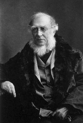
Sir Joseph Dalton Hooker was a British botanist and explorer in the 19th century. He was a founder of geographical botany and Charles Darwin's closest friend. For 20 years he served as director of the Royal Botanical Gardens, Kew, succeeding his father, William Jackson Hooker, and was awarded the highest honours of British science.
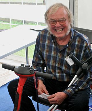
Colin Trevor Pillinger, was an English planetary scientist. He was a founding member of the Planetary and Space Sciences Research Institute at Open University in Milton Keynes, he was also the principal investigator for the British Beagle 2 Mars lander project, and worked on a group of Martian meteorites.

Robert McCormick was a British Royal Navy ship's surgeon, explorer and naturalist.

Beagle Channel is a strait in the Tierra del Fuego Archipelago, on the extreme southern tip of South America between Chile and Argentina. The channel separates the larger main island of Isla Grande de Tierra del Fuego from various smaller islands including the islands of Picton, Lennox and Nueva; Navarino; Hoste; Londonderry; and Stewart. The channel's eastern area forms part of the border between Chile and Argentina and the western area is entirely within Chile.

Penguin Island is one of the smaller of the South Shetland Islands of Antarctica.

The Yahgan are a group of indigenous peoples in the Southern Cone of South America. Their traditional territory includes the islands south of Isla Grande de Tierra del Fuego, extending their presence into Cape Horn, making them the world's southernmost indigenous human population.

The second voyage of HMS Beagle, from 27 December 1831 to 2 October 1836, was the second survey expedition of HMS Beagle, made under her newest commander, Robert FitzRoy. FitzRoy had thought of the advantages of having someone onboard who could investigate geology, and sought a naturalist to accompany them as a supernumerary. At the age of 22, the graduate Charles Darwin hoped to see the tropics before becoming a parson, and accepted the opportunity. He was greatly influenced by reading Charles Lyell's Principles of Geology during the voyage. By the end of the expedition, Darwin had made his name as a geologist and fossil collector, and the publication of his journal gave him wide renown as a writer.

The Sedgwick Museum of Earth Sciences, is the geology museum of the University of Cambridge. It is part of the Department of Earth Sciences and is located on the university's Downing Site in Downing Street, central Cambridge, England. The Sedgwick Museum is the oldest of the eight museums which make up the University of Cambridge Museums consortium.
Brown Bluff is a basalt tuya on the Tabarin Peninsula of northern Antarctica. It formed in the last 1 million years as a result of subglacial eruptions within an englacial lake. The volcano's original diameter is thought to have been about 12–15 kilometers (7.5–9.3 mi) and was probably formed by a single vent. Brown Bluff is divided into four stages: pillow volcano, tuff cone, slope failure, and hyaloclastite delta; and into five structural units.

The Structure and Distribution of Coral Reefs, Being the first part of the geology of the voyage of the Beagle, under the command of Capt. Fitzroy, R.N. during the years 1832 to 1836, was published in 1842 as Charles Darwin's first monograph, and set out his theory of the formation of coral reefs and atolls. He conceived of the idea during the voyage of the Beagle while still in South America, before he had seen a coral island, and wrote it out as HMS Beagle crossed the Pacific Ocean, completing his draft by November 1835. At the time there was great scientific interest in the way that coral reefs formed, and Captain Robert FitzRoy's orders from the Admiralty included the investigation of an atoll as an important scientific aim of the voyage. FitzRoy chose to survey the Keeling Islands in the Indian Ocean. The results supported Darwin's theory that the various types of coral reefs and atolls could be explained by uplift and subsidence of vast areas of the Earth's crust under the oceans.
Commemoration of Charles Darwin began with geographical features named after Darwin while he was still on the Beagle survey voyage, continued after his return with the naming of species he had collected, and extended further with his increasing fame. Many geographical features, species and institutions bear his name. Interest in his work has led to scholarship and publications, nicknamed the Darwin Industry, and his life is remembered in fiction, film and TV productions as well as in numerous biographies. Darwin Day has become an annual event, and in 2009 there were worldwide celebrations to mark the bicentenary of Darwin's birth and the 150th anniversary of the publication of On the Origin of Species.
Vortex Island is an island 0.5 nautical miles (0.9 km) long and 245 m high, lying in the northeast part of Prince Gustav Channel about 2 nautical miles (3.7 km) west-southwest of Corry Island, close south of Trinity Peninsula. Islands in this area were first seen by a party under J. Gunnar Andersson of the Swedish Antarctic Expedition, 1901–04. Vortex Island was first charted by the Falkland Islands Dependencies Survey (FIDS) in August 1945. The FIDS survey party was forced to lie idle there by a whirlwind snowstorm, thus suggesting the name.
Portal Point is a narrow point in the northeast part of Reclus Peninsula, on the west coast of Graham Land. In 1956, a Falkland Islands Dependencies Survey (FIDS) hut was established on the point, from which a route to the plateau was established. So named by the United Kingdom Antarctic Place-Names Committee (UK-APC) in 1960 because the point is the "gateway" of the route.
Earle Island is a small ice-free island 6 kilometres (3 nmi) south-west of Darwin Island which marks the south-western end of the Danger Islands. Following hydrographic work in the area from HMS Endurance in 1977–78, it was named, in association with Beagle Island and other names in the group, after Augustus Earle, an artist on board HMS Beagle.
The Danger Islands are a group of islands lying 13 nautical miles east-south-east of Joinville Island near the tip of the Antarctic Peninsula.

The Ross expedition was a voyage of scientific exploration of the Antarctic in 1839 to 1843, led by James Clark Ross, with two unusually strong warships, HMS Erebus and HMS Terror. It explored what is now called the Ross Sea and discovered the Ross Ice Shelf. On the expedition, Ross discovered the Transantarctic Mountains and the volcanoes Mount Erebus and Mount Terror, named after each ship. The young botanist Joseph Dalton Hooker made his name on the expedition.
The geology of South Georgia and the South Sandwich Islands is part of the largely submerged Scotia Ridge. The island of South Georgia is unusual among oceanic islands for having pre-Cretaceous sedimentary rocks underlying much of the island and a significant portion of felsic igneous rocks. Two-thirds of the island consists of intensely folded flysch, capped with Aptian age fossils, tuff and greywacke in the Cumberland Bay Series. The series includes slate, phyllite, conglomerate, siltstone and sandstone. In the west are basalt flows, pillowed spilite, prehnite and trachyandesite, as well as shale with radiolarite fossils.

