
The San Juan Mountains is a high and rugged mountain range in the Rocky Mountains in southwestern Colorado and northwestern New Mexico. The area is highly mineralized and figured in the gold and silver mining industry of early Colorado. Major towns, all old mining camps, include Creede, Lake City, Silverton, Ouray, and Telluride. Large scale mining has ended in the region, although independent prospectors still work claims throughout the range. The last large-scale mines were the Sunnyside Mine near Silverton, which operated until late in the 20th century, and the Idarado Mine on Red Mountain Pass, which closed in the 1970s. Famous old San Juan mines include the Camp Bird and Smuggler Union mines, both located between Telluride and Ouray.

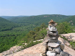
The Boundary Waters Canoe Area Wilderness comprises 1,090,000 acres (440,000 ha) of pristine forests, glacial lakes, and streams in the Superior National Forest. Located entirely within the U.S. state of Minnesota at the Boundary Waters, the wilderness area is under the administration of the United States Forest Service. Efforts to preserve the primitive landscape began in the 1900s and culminated in the Boundary Waters Canoe Area Wilderness Act of 1978. The area is a popular destination for canoeing, hiking, and fishing, and is the most visited wilderness in the United States.

The Skykomish River is a 29-mile (47 km) long river in the U.S. state of Washington which drains the west side of the Cascade Mountains in the southeast section of Snohomish County and the northeast corner of King County. The river starts with the confluence of the North Fork Skykomish River and South Fork Skykomish River approximately one mile west of Index, then flowing northwesterly towards Puget Sound. It is joined by the Sultan River and the Wallace River at Sultan. It then meets the Snoqualmie River to form the Snohomish River at Monroe. The Snohomish River continues along the river valley eventually dumping into Port Gardner Bay on Possession Sound.
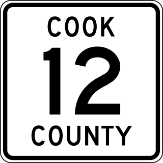
County State-Aid Highway 12 (CSAH 12), also known as the Gunflint Trail, or County Road 12 (CR 12), is a 57-mile (92 km) paved roadway and National Scenic Byway in Cook County, Minnesota, that begins in Grand Marais and ends at Saganaga Lake in the Boundary Waters Canoe Area Wilderness (BWCAW), near the U.S. border with Ontario. It provides access to many of the entry points in the BWCAW.

Cougar Mountain Regional Wildland Park is a regional park in King County, Washington, near the towns of Bellevue and Issaquah. The park was established in June 1983 to protect the central core of Cougar Mountain, the park covers 3,115 acres (12.61 km2) with 38 miles (61 km) of hiking trails and 12 miles (19 km) of equestrian trails.

The Hualapai Mountains are a mountain range located in Mohave County, east of Kingman, Arizona. Rising up to 8,417 feet at its highest peak, the higher elevations of the Hualapai Mountains support Madrean Sky Island habitats, and are host to a plethora of unique flora and fauna in a wide range of microclimates, high above the surrounding Mojave Desert.
Popolopen is the name of several related landmarks mainly within the Hudson Highlands of Orange County, New York. These include a peak, Popolopen Torne—or simply "The Torne", and a short and steep-sided nearby valley officially called Hell Hole, but often Popolopen Gorge. Popolopen Creek runs through this valley. The Popolopen Bridge spans its mouth at the Hudson River and is crossed by Route 9W. Popolopen Lake feeds the headwaters of its namesake creek. Despite local usage, the United States Board on Geographical Names recognizes only the lake, creek and bridge as bearing the name "Popolopen."

The Kettle River Range, often called the Kettle Range, is the southernmost range of the Monashee Mountains, located in far southeastern British Columbia, Canada and Ferry County, Washington, in the United States. Most of the northern half of the range is protected by the Colville National Forest and the southern half of the range is located on the Colville Indian Reservation. The highest peak is Copper Butte, which reaches 2,177 metres (7,142 ft). The range is crossed by Washington State Route 20 at Sherman Pass.

The Castle Dome Mountains are a mountain range in Yuma County, Arizona, within the Kofa National Wildlife Refuge. Castle Dome Peak, the high point of the range, is a prominent butte and distinctive landmark. The peak is 3,780 feet (1,152 m) high, and is located at 33°05′04″N 114°08′36″W. Castle Dome was named by American soldiers at old Fort Yuma in the 1880s. Early Spanish explorers called the same peak Cabeza de Gigante, "Giant's Head."

Castle Dome Landing, Arizona is a ghost town in the Castle Dome Mountains of Yuma County in the U.S. state of Arizona. It was first settled as a transport depot and mining camp around 1863 in what was then the Arizona Territory.

Lake Dorothy is a lake in King County, Washington. First labeled on Oliver P Anderson's "New Map of the County of King, State of Washington, 1894"; the name was bestowed by Anderson for his daughter Dorothy Louise Anderson (1893-1912), a member of Sigma Kappa sorority. It is one of the largest lakes in the area and is the source of the East Fork Miller River.
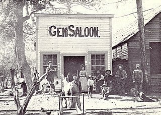
Manchester was a mining town in the Los Burros Mining District in the southern Big Sur region of Monterey County, California from about 1875 to 1895. The town was reached by a 20 miles (32 km) road from King City to Jolon. From Jolon travelers could ride or take a stage or wagon to the Wagon Caves, followed by a difficult 14 miles (23 km) trail over the steep Santa Lucia Mountains to the site, about 4 miles (6.4 km) inland of Cape San Martin. Prospecting began in the area in the 1850s.
Anderson Lake is a small freshwater lake located on the southern slope of Dog Mountain between Marten Lake and Dream Lake, part of the Alpine Lakes Wilderness in King County, Washington. Anderson Creek exits Anderson Lake to the south and empties into the Taylor River. The lake is periodically stocked with rainbow trout.
Myrtle Lake is a freshwater lake located on the northern slope of Rampart Mountain East of Cow Creek Meadows, in Chelan County, Washington. Self-issued Alpine Lake Wilderness permit required for transit within the Glacier Peak Wilderness area. Because Myrtle Lake is at the heart of the Alpine Lakes Wilderness, the lake is a popular area for hiking, swimming, and fishing brook trout.
Lake Kanim is a set of small freshwater lakes located on a clif of the south skirt of Lennox Mountain, in King County, Washington. Lake Kanim is the nascent source of the North Fork of the Snoqualmie River. The lake and its accompanying waterfall were named after Jerry Kanim who was the leader of Snoqualmie people.
Coney Lake is a small alpine lake located in the Alpine Lakes Wilderness in King County, Washington. Coney Lake sits in a bowl formed by a rocky double cliff bifurcation of the south ridge of Lennox Mountain that connects to Coney's Cones-South Peak. Coney Lake is the origin of Coney Creek, which is a tributary of the west fork of Miller River. Lake Kanim is situated over the opposite side of the ridge as Lennox Mountain splits towards Canoe Peak.
Lennox Mountain is an 5,898-foot (1,798 m) mountain summit located in King County of Washington state. Lennox mountain extends a ridge South towards Canoe peak making a bowl structure where Lake Kanim sits, the origin source of the North Fork of the Snoqualmie River. From Lennox Mountain a second ridge with rocky double cliffs is formed running East towards Coney's Cones-South Peak where the Coney Basin and Coney Lake sit which produces a tributary of the west fork of Miller River. Access to Lennox Mountain is from Bare Mountain trailhead which reaches Canoe Peak.
Gold Lake is a freshwater lake located on a valley on the west skirt of Wild Goat Peak, in King County, Washington. Gold Lake is surrounded by prominent peaks and lakes at the heart of the Alpine Lakes Wilderness, including Big Snow Mountain and Iron Cap Mountain.

Rock Creek Lake is an alpine lake along the Elkhorn Crest trail in the southern end of the Elkhorn Mountains in Baker County, eastern Oregon. It is located on the northern slope of Rock Creek Butte, the highest point in the Elkhorn Mountains range. While the lake is located on a glacial cirque, it is part of the West Fork Rock Creek drainage basin.

