
The Snoqualmie River is a 45-mile (72 km) long river in King County and Snohomish County in the U.S. state of Washington. The river's three main tributaries are the North, Middle, and South Forks, which drain the west side of the Cascade Mountains near the town of North Bend and join near the town of Snoqualmie just above the Snoqualmie Falls. After the falls the river flows north through rich farmland and the towns of Fall City, Carnation, and Duvall before meeting the Skykomish River to form the Snohomish River near Monroe. The Snohomish River empties into Puget Sound at Everett. Other tributaries of the Snoqualmie River include the Taylor River and the Pratt River, both of which enter the Middle Fork, the Tolt River, which joins at Carnation, and the Raging River at Fall City.

The Sauk River is a tributary of the Skagit River, approximately 45 miles (72 km) long, in northwestern Washington in the United States. It drains an area of the high Cascade Range in the watershed of Puget Sound north of Seattle. The river is a popular destination for fly fishing. It is a National Wild and Scenic River.

The Skykomish River is a 29-mile (47 km) long river in the U.S. state of Washington which drains the west side of the Cascade Mountains in the southeast section of Snohomish County and the northeast corner of King County. The river starts with the confluence of the North Fork Skykomish River and South Fork Skykomish River approximately one mile west of Index, then flowing northwesterly towards Puget Sound. It is joined by the Sultan River and the Wallace River at Sultan. It then meets the Snoqualmie River to form the Snohomish River at Monroe. The Snohomish River continues along the river valley eventually dumping into Port Gardner Bay on Possession Sound.
The Henry M. Jackson Wilderness is a 103,297-acre (41,803 ha) designated wilderness area in the state of Washington, United States. The area lies adjacent to the southwest corner of the Glacier Peak Wilderness, northwest of Stevens Pass on U.S. Highway 2 and northeast of the town of Skykomish, Washington. Wild Sky Wilderness is located immediately southwest of the Henry M. Jackson Wilderness. While the wilderness straddles the Cascade Mountain Range, most of it is in the westside ecotype. The wilderness lies in parts of Snoqualmie, Mount Baker, and Wenatchee national forests.

Cougar Mountain Regional Wildland Park is a regional park in King County, Washington, near the towns of Bellevue and Issaquah. The park was established in June 1983 to protect the central core of Cougar Mountain, the park covers 3,115 acres (12.61 km2) with 38 miles (61 km) of hiking trails and 12 miles (19 km) of equestrian trails.

The Alpine Lakes Wilderness is a large wilderness area spanning the Central Cascades of Washington state in the United States. The wilderness is located in parts of Wenatchee National Forest and Snoqualmie National Forest, and is approximately bounded by Interstate 90 and Snoqualmie Pass to the south and U.S. Route 2 and Stevens Pass to the north. The Alpine Lakes is the largest wilderness area near the population centers of Puget Sound, counted at 414,161 acres (167,605 ha) following the 2014 expansion.
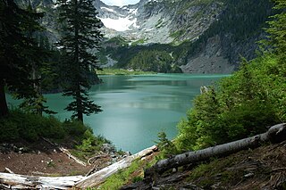
Kanim Falls is the major waterfall on the North Fork of the Snoqualmie River. It is located at the outlet of Lake Kanim and is near the source of the North Fork of the Snoqualmie River. The falls were named after Chief Jerry Kanim who was the leader of Snoqualmie people.
The Taylor River is a river in King County in Washington.

Lake Dorothy is a lake in King County, Washington. First labeled on Oliver P Anderson's "New Map of the County of King, State of Washington, 1894"; the name was bestowed by Anderson for his daughter Dorothy Louise Anderson (1893-1912), a member of Sigma Kappa sorority. It is one of the largest lakes in the area and is the source of the East Fork Miller River.
The Miller River is a river in King County, Washington. Named for 1890s prospector John Miller, it is a tributary of the Skykomish River, which it joins near the community of Miller River. The Miller River is about 3.5 miles (5.6 km) long from the confluence of its main tributaries, the East Fork and West Fork. Miller River Campground is located just downriver from the confluence.
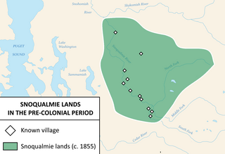
The Snoqualmie people are a Lushootseed-speaking Southern Coast Salish people indigenous to the Snoqualmie Valley, located in east King and Snohomish counties in the state of Washington.
Angeline Lake is a freshwater lake located on the northern slope of Iron Cap Mountain between Otter Lake, Azure Lake and Big Heart Lake, in King County, Washington. Self-issued Alpine Lake Wilderness permit required for transit within the Big Snow Mountain area. West Fork Foss River exits Angeline Lake into a canyon that produces Angeline Falls downstream from Chetwoot Lake to Delta Lake. Because Angeline Lake is at the heart of the Alpine Lakes Wilderness, the lake is a popular area for hiking, swimming, and fishing golden trout, rainbow trout, and cutthroat trout.
Anderson Lake is a small freshwater lake located on the southern slope of Dog Mountain between Marten Lake and Dream Lake, part of the Alpine Lakes Wilderness in King County, Washington. Anderson Creek exits Anderson Lake to the south and empties into the Taylor River. The lake is periodically stocked with rainbow trout.
Myrtle Lake is a freshwater lake located on the northern slope of Big Snow Mountain between Snoqualmie Lake and Chetwoot Lake, in King County, Washington. Self-issued Alpine Lake Wilderness permit required for transit within the Big Snow Mountain area. Because Myrtle Lake is at the heart of the Alpine Lakes Wilderness, the lake is a popular area for hiking, swimming, and fishing rainbow trout and coastal cutthroat trout.
Bear Lakes is a set of small freshwater lakes located on the southwest skirt of Canoe Peak, in King County, Washington. Several mines are located in the vicinity of Bear Lakes. Access is from Bear Creek Trail which continues along abandoned and mostly overgrown mine routes. Cable reels and other mining artifacts are frequent along the trail and in the surrounding areas of the lake. Lake Kanim is a short distance north over Canoe Peak towards Lennox Mountain, and Paradise Lakes are west of Bear Lakes.

Jerry Kanim was a chief of the Snoqualmie people from 1914 until his death in 1956. Chief Jerry Kanim was the most influential and most recognized political figure of the Snoqualmie in the 20th century. Kanim was appointed chief of his people in 1914 and was not replaced as chief until Earnest Barr was chosen 30 years later, after his death in 1956. Kanim was active in pursuing land claims and fishing rights as well as financial and real estate compensation on behalf of the Snoqualmie. He also was an advocate of information about the history and traditions of his people, frequently providing replicas of folkloric artifacts for anthropologists. Chief Jerry Kanim was the nephew of Chief Patkanim, one of the signers of the Treaty of Point Elliott. He lived with the Sauk-Suiattle Indian Tribe of Washington near the city of Darrington.
Coney Lake is a small alpine lake located in the Alpine Lakes Wilderness in King County, Washington. Coney Lake sits in a bowl formed by a rocky double cliff bifurcation of the south ridge of Lennox Mountain that connects to Coney's Cones-South Peak. Coney Lake is the origin of Coney Creek, which is a tributary of the west fork of Miller River. Lake Kanim is situated over the opposite side of the ridge as Lennox Mountain splits towards Canoe Peak.
Lennox Mountain is an 5,898-foot (1,798 m) mountain summit located in King County of Washington state. Lennox mountain extends a ridge South towards Canoe peak making a bowl structure where Lake Kanim sits, the origin source of the North Fork of the Snoqualmie River. From Lennox Mountain a second ridge with rocky double cliffs is formed running East towards Coney's Cones-South Peak where the Coney Basin and Coney Lake sit which produces a tributary of the west fork of Miller River. Access to Lennox Mountain is from Bare Mountain trailhead which reaches Canoe Peak.
Gold Lake is a freshwater lake located on a valley on the west skirt of Wild Goat Peak, in King County, Washington. Gold Lake is surrounded by prominent peaks and lakes at the heart of the Alpine Lakes Wilderness, including Big Snow Mountain and Iron Cap Mountain.
Paradise Lakes are a set of three small freshwater lakes located on a clif of the north skirt of Bare Mountain, in King County, Washington. Paradise Lakes sit in a bowl formed by a ridge that connects to the south ridge of Lennox Mountain. Paradise Lakes have an outflow that is a tributary of the North Fork of the Snoqualmie River from its source, Lake Kanim.

