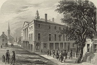
The First United States Congress, consisting of the United States Senate and the United States House of Representatives, met from March 4, 1789, to March 4, 1791, during the first two years of George Washington's presidency, first at Federal Hall in New York City and later at Congress Hall in Philadelphia. With the initial meeting of the First Congress, the United States federal government officially began operations under the new frame of government established by the 1787 Constitution. The apportionment of seats in the House of Representatives was based on the provisions of Article I, Section 2, Clause 3 of the Constitution. Both chambers had a Pro-Administration majority. Twelve articles of amendment to the Constitution were passed by this Congress and sent to the states for ratification; the ten ratified as additions to the Constitution on December 15, 1791, are collectively known as the Bill of Rights.

Tornado is a census-designated place (CDP) in Kanawha County, West Virginia, United States. Tornado is also known as Upper Falls, the U.S. Census Bureau's official name for the community. The United States Board on Geographic Names declared the community's official name to be Tornado in 2013 due to a request from the Kanawha County Commission, which determined that residents of the community supported the name Tornado over Upper Falls. It is also known as Andrews Heights, Big Bend and Upper Falls of Coal River.

The Unadilla River is a 71-mile-long (114 km) river in the Central New York Region of New York State. The river begins northeast of the hamlet of Millers Mills and flows generally south to the village of Sidney, where it converges with the Susquehanna River, which drains into the Chesapeake Bay, a bay of the Atlantic Ocean.

The Forty-ninth United States Congress was a meeting of the legislative branch of the United States federal government, consisting of the United States Senate and the United States House of Representatives. It met in Washington, D.C. from March 4, 1885, to March 4, 1887, during the first two years of Grover Cleveland's first presidency. The apportionment of seats in the House of Representatives was based on the Tenth Census of the United States in 1880. The Senate had a Republican majority, and the House had a Democratic majority.

The Bears Paw Mountains are an insular-montane island range in North-Central Montana, USA, located approximately 10 miles south of Havre, Montana. Baldy Mountain, which rises 6,916 feet above sea level, is the highest peak in the range.

The High Sierra Trail (HST) is a hiking trail in Sequoia National Park, California. The trail crosses the Sierra Nevada from west to east. According to the Yosemite Decimal System, the HST is a Class 1/Class 2 trail, which means simple scrambling, with the possibility of occasional use of the hands for balance.
Moose Creek can refer to:
Title 43 of the United States Code outlines the role of Public Lands in the United States Code.

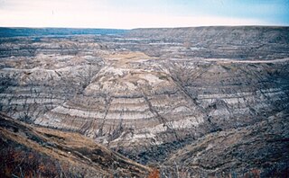
The Bearpaw Formation, also called the Bearpaw Shale, is a geologic formation of Late Cretaceous (Campanian) age. It outcrops in the U.S. state of Montana, as well as the Canadian provinces of Alberta and Saskatchewan, and was named for the Bear Paw Mountains in Montana. It includes a wide range of marine fossils, as well as the remains of a few dinosaurs. It is known for its fossil ammonites, some of which are mined in Alberta to produce the organic gemstone ammolite.
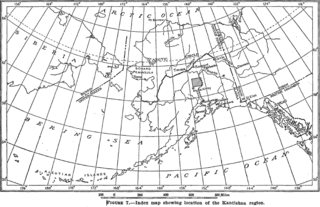
Kantishna is an unincorporated community in Denali Borough, Alaska, United States, within Denali National Park and Preserve. Founded as a gold mining camp in 1905, it endured longer than similar communities in the area, having been constructed nearest to the source of the gold. It lies in the Kantishna Hills at the junction of Eureka Creek and Moose Creek, 3 mi (5 km) northwest of Wonder Lake, and near the mouth of the Kantishna River. Although the community was once also called "Eureka", the Board on Geographic Names officially ruled in favor of "Kantishna" in 1944, the name given to the post office that was built at the site in 1905. Its elevation is 1,696 feet (517 m).
The Belly River Formation is a stratigraphical unit of Late Cretaceous age in the Western Canadian Sedimentary Basin.

William Thomas Pecora was an American geologist.
The Edmonton Group is a Late Cretaceous to early Paleocene stratigraphic unit of the Western Canada Sedimentary Basin in the central Alberta plains. It was first described as the Edmonton Formation by Joseph Burr Tyrrell in 1887 based on outcrops along the North Saskatchewan River in and near the city of Edmonton. E.J.W. Irish later elevated the formation to group status and it was subdivided into four separate formations. In ascending order, they are the Horseshoe Canyon, Whitemud, Battle and Scollard Formations. The Cretaceous-Paleogene boundary occurs within the Scollard Formation, based on dinosaurian and microfloral evidence, as well as the presence of the terminal Cretaceous iridium anomaly.
The Eastend Formation is a stratigraphical unit of Maastrichtian age in the Western Canadian Sedimentary Basin.
Bearpaw Lake is located in Grand Teton National Park, in the U. S. state of Wyoming. Bearpaw Lake is south of Trapper Lake and north of Leigh Lake. Bearpaw Lake is an easy to moderate 8-mile (13 km) round trip hike along the Leigh Lake Trail.
The Blood Reserve Formation, also known as the Blood Reserve Sandstone, is a geologic formation of Late Cretaceous (Campanian) age in the Western Canada Sedimentary Basin. It is present in southwestern Alberta, Canada, and was named for Blood Indian Reserve No. 148 by L.S. Russell in 1932. It is an aquifer and a source of fresh groundwater.
Nakonanectes bradti is an elasmosaurid plesiosaur of the late Cretaceous found in 2010 the state of Montana in the United States. It is one of the earliest known elasmosaurids to have lived in North America. Unlike other elasmosaurids, it has a relatively short neck.
Moose Creek heads in Denali National Park and Preserve and is a tributary of the Bearpaw River in central Alaska. Wonder Lake drains into Moose Creek. Variant names include Hutenaal'eey No' and Hutenaal'eeyh No' Hutl'ot.
Diamond or Diamond City is located at the junction of Moose Creek and Bearpaw River, 18 miles (29 km) east of Chilchukabena Lake in Denali Borough, Alaska. Diamond was established c. 1905 as a mining camp at the head of small-boat navigation on the Bearpaw River. It had a post office in 1906 and then again from 1929 until 1951. Diamond is now abandoned.

