Langley was a federal electoral district in the province of British Columbia, Canada, that was represented in the House of Commons of Canada from 2004 to 2015. It was a 327 km² in area with 117,858 people located in the suburbs of the Lower Mainland.

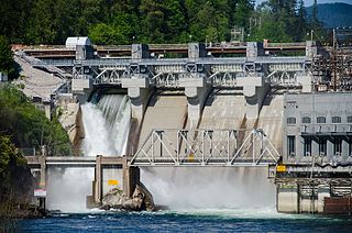
The Stave River is a tributary of the Fraser, joining it at the boundary between the municipalities of Maple Ridge and Mission, about 35 kilometres (22 mi) east of Vancouver, British Columbia, Canada, in the Central Fraser Valley region.

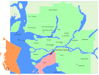
Annacis Island is an island located in the south arm of the Fraser River, in Delta, British Columbia. The island is now mostly industrial, and it contains one of Metro Vancouver's secondary wastewater treatment plants.

Barnston Island is an unincorporated island located in the Greater Vancouver metropolitan area of British Columbia, Canada. Most of the island is part of the Greater Vancouver Electoral Area A; the remainder is Barnston Island Indian Reserve No. 3, which is outside Electoral Area A limits and is under the governance of the Katzie First Nation, headquartered across the river at their main reserve in Pitt Meadows. Although the island is unincorporated and not officially part of any municipality, mailing addresses on the island use Surrey as the city name.

Fort Langley National Historic Site, commonly shortened to Fort Langley, is a former trading post of the Hudson's Bay Company, now located in the community of Fort Langley opposite McMillan Island. Commonly referred to as "the birthplace of British Columbia", it is designated a National Historic Site and is administered by Parks Canada.
The Squamish Nation, Sḵwx̱wú7mesh Úxwumixw in Sḵwx̱wú7mesh Sníchim, is an Indian Act government originally imposed on the Squamish (Sḵwx̱wú7mesh) by the Federal Government of Canada in the late 19th century. The Squamish are Indigenous to British Columbia, Canada. Their band government comprises 16 elected councillors, serving four-year terms, with an elected band manager. Their main reserves are near the town of Squamish, British Columbia and around the mouths of the Capilano River, Mosquito Creek, and Seymour River on the north shore of Burrard Inlet in North Vancouver, British Columbia.
The Alkali Lake Indian Band, also known as the Esketemc First Nation, is a First Nations government of the Secwepemc (Shuswap) people, located at Alkali Lake in the Cariboo region of the Central Interior of the Canadian province of British Columbia. It was created when the government of the then-Colony of British Columbia established an Indian Reserve system in the 1860s. It is one of three Secwepemc bands that is not a member of either the Shuswap Nation Tribal Council or the Northern Shuswap Tribal Council.
James McMillan (1783–1858) was a fur trader and explorer for the North West Company and Hudson's Bay Company. He led some of the earliest surveys of the lower Fraser River and founded Fort Langley for the HBC in 1827, and was its first Chief Trader.
Albion, British Columbia is a neighbourhood in Maple Ridge, British Columbia and is one of several small towns incorporated within the municipality at its creation. It is the oldest non-indigenous community of the district's settlements, and is only slightly younger than Fort Langley, adjacent across the Fraser River, and Kanaka Creek, which is just to the west and lies along the creek of the same name. Its official definition is the area bounded by the Fraser River, Kanaka Way, and 240th Street, but in its historic sense it means the community centred on and flanking 240th Street and adjoining areas along the Fraser River waterfront and around the Maple Ridge Fairgrounds, while along Kanaka Way and also on the near bank of Kanaka Creek, the creek, is historically the community of Kanaka Creek. Burgeoning newer home construction east of 240th Street near the Lougheed Highway is also often referred to as part of Albion.

Murrayville is a small community in the Township of Langley in the Lower Mainland region of British Columbia, Canada.
Nicomen Island is an island in the Fraser River east of Mission and between Deroche (E) and Dewdney (W). Located on the river's north side, and separated from the foot of the Douglas Ranges by Nicomen Slough, the island is near-totally given over to agriculture and constitutes a rural community in its own right, although "downtown Dewdney" is located near its western end and the Indian Reserve of the Lakahahmen First Nation is located about mid-way along its north side.

Año Nuevo State Marine Conservation Area (SMCA) is one of two adjoining marine protected areas off the coast of San Mateo and Santa Cruz Counties, on California’s central coast.The area is approximately 55 miles south of San Francisco. The SMCA is 11.07 square miles. Except for limited taking of giant kelp, all living marine resources are protected.
Trincomali Channel is a channel or strait in the Gulf Islands of British Columbia, Canada, located between Saltspring Island (W) and Galiano Island (E). It is named for HMS Trincomalee which was assigned to the Royal Navy's Pacific Station at Esquimalt in the 19th Century.
The Douglas First Nation, aka the Douglas Indian Band, Douglas Band, or Xa'xtsa First Nation, are a band government of the In-SHUCK-ch Nation, a subgroup of the larger St'at'imc people, also referred to as Lower Stl'atl'imx. The Douglas, Skatin and Samahquam communities are related through familial ties as well as culturally and linguistically. The In-SHUCK-ch are the southernmost of the four divisions making up the Lillooet ethnographic group. The Douglas First Nation's main community is at Xa'xtsa, a village on their main reserve at the head of Harrison Lake, near the former gold rush port-town of Port Douglas.
The Leq' a: mel First Nation, formerly known as the Lakahahmen First Nation, is a First Nations band government whose community and offices are located in the area near Deroche, British Columbia, Canada, about 12 kilometres east of the District of Mission. They are a member government of the Sto:lo Nation tribal council, which is one of two tribal councils of the Sto:lo.
Milner is a rural village and locality in the Township of Langley in the Fraser Valley of British Columbia, Canada. It is located along the British Columbia Electric Railway line (now the Southern Railway of B.C. northeast of the City of Langley and just southwest of Fort Langley.
The Salmon River is a small river in the Township of Langley in the Lower Mainland region of British Columbia, Canada, flowing northwest then northeast to enter Bedford Channel, which separates McMillan Island from Fort Langley, which is just southwest.


