
Mahakali is one of the fourteen zones located in the Far-Western Development Region of Nepal, covering an area of 6,205 km2 in the most western part of the country. It stretches along Nepal's far western border with India, marked by the Kali River or Mahakali River, which originates from Limpiyadhura, a disputed location for whether or not the Tri-country border point of Nepal and India with China.
Dhangadhi is a sub-metropolitan city and the district headquarters of Kailali District in Sudurpashchim Pradesh of Nepal. It shares a border with Uttar Pradesh, India in the south, Godawari and Gauriganga Municipality in the North, Kailari Rural Municipality in the east and Kanchanpur District in the west. Dhangadhi is a sub-metropolis divided into 19 wards. It has a population of about 147,181 and thus is the 10th biggest city of Nepal. It has an area of 261.75 km2. It is one of the major cities of far-western region of Nepal along with Bhimdatta.
Kanchanpur District (Nepali: कञ्चनपुर जिल्लाListen , a part of Province No. 7 in Terai plain, is one of seventy-five districts of Nepal. The district, with Bhimdatta as its district headquarters, covers an area of 1,610 square kilometres and had a population of 134,868 in 2001 and 171,304 in 2011. It is located in southern-west of Nepal. It is bordered with Kailali district in east, Dadeldhura district in north and with modern-day india in south and west.

Saptari, a part of Province No. 2, is one of the seventy-five districts of Nepal. Its district headquarter is Rajbiraj. This district covers an area of 1,363 km² and has a population (2011) of 639,284 which makes it the 10th most populated district of Nepal. Saptari is renowned for its agricultural output, and is bordered on the east by the massive Sapta Koshi river.

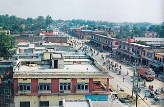
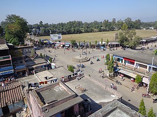
Bheemdatt, is a municipality in far western Nepal. Mahendranagar is a city and the headquarters of the district of Kanchanpur in Mahakali Zone. The city and the municipality was named Mahendranagar in the honour of late king Mahendra of Nepal. After becoming a republic in 2008, the Mahendranagar municipality name was changed to Bheemdatt municipality in honour of the revolutionary farmer leader Bhimdatta Panta, killed in 1953 by Indian forces inside the borders of Nepal.

Kanchan Rup is a Municipality in Saptari District in the Sagarmatha Zone of south-eastern Nepal. This municipality was formed on 18 May 2014 by merging nine villages around it i.e. Baramjhiya, Badgama, Theliya, Jagatpur, Kanchanpur, Pipra (Purba), Rupnagar, Dharmpur and Ghoghanpur.
Daijee is a Bedkot Municipality in Kanchanpur District in the Mahakali Zone of south-western Nepal. At the time of the 1991 Nepal census it had a population of 6597 people living in 2088 individual households.
Laksmipur is a village development committee in Kanchanpur District in the Mahakali Zone of south-western Nepal. The former village development committee was converted into Municipality merging with existing Rampur Bilaspur, Laksmipur, Mahakali and Sripur village development committee on 18 May 2014. At the time of the 1991 Nepal census it had a population of 11,767.
Raikawar Bichawa is a village development committee in Kanchanpur District in the Mahakali Zone of south-western Nepal. At the time of the 1991 Nepal census it had a population of 9936 people living in 1391 individual households. There Are 9 Ward in Raikwar Bichawa VDC.
Rampur Bilaspur is a town in Kanchanpur District in the Mahakali Zone of south-western Nepal. The former village development committee was converted into Municipality merging with existing Rampur Bilaspur, Laxmipur, Mahakali and Sreepur, Mahakali village development committee on 18 May 2014. At the time of the 1991 Nepal census it had a population of 11,841 people living in 1650 individual households.
Punarwas is a Municipality in Kanchanpur District in the Mahakali Zone of south-western Nepal. The new Municipality was established on 18 May 2014 by merging the existing 3 Village Development Committees i.e. Parasan, Tribhuwanbasti and Kalika. At the time of the 2011 Nepal census, it had a population of 43,996 people living in Punarwas.
Raji is a small Sino-Tibetan language of Nepal and Uttarakhand, India. Speakers were recently nomadic.
Mahakali is a municipality located in Kanchanpur District of Province No. 7 of Nepal. The municipality was formed by merging two existing Villages—Dodhara and Chandani—on 18 May 2014. The office of the municipality is that of the former Dodhara village development committee.
Krishnapur is a municipality in Kanchanpur District in the Mahakali Zone of the far-western development region of Nepal. In the 2011 national census, there were 36,706 people living in 6,723 individual households.

Sudurpashchim Pradesh is one of the seven provinces established by the new constitution of Nepal which was adopted on 20 September 2015. It borders the Tibet Autonomous Region of China to the north, Karnali Pradesh and Province No. 5 to the east, and the Indian states of Uttarakhand to the west and Uttar Pradesh to the south. Initially known as Province No. 7, the newly elected Provincial Assembly adopted Sudurpashchim Pradesh as the permanent name for the province in September 2018. As per a 28 September 2018 Assembly voting, the city of Godawari has been declared the capital of the Province. The province is coterminous with the former Far-Western Development Region, Nepal.

Kanchanpur is a village in Bankura II CD Block in Bankura Sadar subdivision of Bankura district in the state of West Bengal, India
Shuklaphanta is a municipality in Kanchanpur District in the Mahakali Zone of south-western Nepal. The new municipality was formed by merging two existing villages—Jhalari and Pipaladi—on 18 May 2014. The office of the municipality is that of the former Jhalari village development committee.
