Beekman Park

Last updated
Beekman Park
Beekman Park - North end.JPG
The northern entrance to Beekman Park from U.S. Route 44.
Beekman Park
Type Local park
Location Amenia (CDP), New York
Coordinates 41°50′42″N73°33′43″W / 41.845°N 73.562°W / 41.845; -73.562 Coordinates: 41°50′42″N73°33′43″W / 41.845°N 73.562°W / 41.845; -73.562
Area47.7 acres (19.3 ha)
Created1983-1985
Operated byAmenia Department of Public Works
OpenAll year
Parking75 spaces

Beekman Park is a small local park in the census-designated place of Amenia, part of Dutchess County, New York. It is located on U.S. Route 44 and is visible off New York State Route 22 and New York State Route 343.

Contents

In 1974, the land upon which the park is located was sold to the Town of Amenia by Walter Beekman for the sum of $1. The park was officially opened in 1983. [1] Before the park existed, it was the site of Lake Amenia, formed in the 1920s by a freshwater dam over a sawmill pond at the intersection of Lake Amenia Road and West Lake Amenia Road. The dam's original use was to power a nearby saw mill where, with the new lake in place, people now had the opportunity to swim. During the 1920s, the lake became surrounded by cottages, pavilions, docks, and some railings. [1]

Lake Amenia remained intact for another 30 years, however, in 1955, Hurricane Diane struck the area and eradicated any trace of the lake. The storm's heavy rains caused the lake's water gates to fail. The resulting flood drained the lake. This area is now part of the New York State Wetlands. In 1974, the land that makes up the park, including the remains of the lake, now the wetlands, were sold to the Town of Amenia for a single dollar, by Walter Beekman. Groups of volunteers began construction on the park, which included ball fields. The park officially opened in 1983, with the first Little League games being played on one of their fields, with two more fields soon after. The park remains in active use to this date. [1]

History of Lake Amenia

Main intersection in Amenia of routes 22 and 343, near the northern edge of where Lake Amenia used to sit. Route 343 at US 44 and 22.jpg
Main intersection in Amenia of routes 22 and 343, near the northern edge of where Lake Amenia used to sit.

On the site of Beekman Park was the former Lake Amenia, a shallow, one and a half acre-wide freshwater lake in the center of Amenia. The lake first originated as a millpond for a local corn and grain mill in the area. Eventually, the mill changed over to a sawmill, [2] and during the 1920s, a dam was built in the millpond, creating Lake Amenia. [1] The lake had two streams that flowed water in and out of the body. One ran near the local pizzeria and one ran near the current-day tennis courts. The freshwater lake became an instant tourist destination two hours north of New York City. People took advantage of the lake, including Beekman and Beekman Inc., a tourist agency developed by two brothers. They used the area around Lake Amenia to develop theaters and a living environment. The lake even had a cemetery built in one of the islands, which exists to this date as Amenia Island Cemetery. People would come to the lake for vacationing, which included a pool hall in the post office, beaches, and even a brand new golf course. Summer vacationers would take the train to Amenia Station on the New York Central Railroad to visit the lakeside resorts and summer camps on the lake. [2]

As popular as the community had become, there were no doubts that the end of vacationing in Amenia would soon imminent. In 1955, during the destruction left by Hurricane Diane swept through New York and Pennsylvania, the dam on Lake Amenia burst. [3] Local folklore claims the floodgates to open Lake Amenia's dam were supposed to be opened for the high waters. However, the dam keeper dropped his keys into the rushing waters of Lake Amenia, and the resulting outflow caused a catastrophe. [1]

The flooding overtook much of the community, including the golf course, and although the flooding receded, the dam was never repaired. The community could not adapt to the sweeping changes from flooding and the popular community became an economic ghost town. Locals reported that the once busy streets of Amenia became empty storefronts. [4] Much of the lake drained into wetlands, some of which has been adaptive into the Wassaic portion of the New York State Wetlands. [5] People often would comment that Lake Amenia Road, named after the lake on the southern side of Beekman Park, [6] served no lake. [2]

Currently

The fields at Beekman Park, the ball fields are important in Amenia Beekman Park fields.JPG
The fields at Beekman Park, the ball fields are important in Amenia

After the flooding of Hurricane Diane, the former wetlands became the ownership of Walter Beekman from Beekman and Beekman Inc. He kept ownership of the land for only nineteen years before selling the land to the town of Amenia in 1974 for one dollar. The land remained unkept at that point, until the 1980s, when groups of volunteers (funded by the town) started installing ball fields and park like scenery. In 1983, Beekman Park was open for business as the new local park. In 1985, the local baseball fields started hosting their own games for locals team on the local Don Herring Field. Some of the former lake remains, including a portion of the former dam in the southwestern corner of the park, [1] and Amenia Island Cemetery still stands along New York State Route 343 towards Sharon, Connecticut, but on stable ground. [2] On May 14, 2009, the town of Amenia secured $3,829 (2009 USD) from their recreation fund to help make improvements to Beekman Park, and on June 11, 2009, the money distribution was approved. [7]

The park is made up mainly of three baseball and softball fields. The three fields are named after famous players in Amenia, including one named for William "Doc" Bartlett, [ who? ] which was opened in 1985. There are some undeveloped parts, with a house running along the northern edge of the park. At the northeast corner, there is a remnant of the old dam that impounded former Lake Amenia. There are two ways to access Beekman Park, one by foot and one by car. The first is on U.S. Route 44, where the parking lot (which holds approximately 75 cars), is located. The second, a pedestrian entrance, is at Broadway and East Broadway Avenues. [1]

See also

Related Research Articles

<span class="mw-page-title-main">Dutchess County, New York</span> County in New York, United States

Dutchess County is a county in the U.S. state of New York. As of the 2020 census, the population was 295,911. The county seat is the city of Poughkeepsie. The county was created in 1683, one of New York's first twelve counties, and later organized in 1713. It is located in the Mid-Hudson Region of the Hudson Valley, north of New York City.

<span class="mw-page-title-main">Beekman, New York</span> Town in New York, United States

Beekman is a town in Dutchess County, New York, United States. It is part of the Poughkeepsie–Newburgh–Middletown, NY Metropolitan Statistical Area as well as the larger New York–Newark–Bridgeport, NY-NJ-CT-PA Combined Statistical Area. The population was 14,172 at the 2020 census. The town was named after Henry Beekman, a 17th-century land owner.

<span class="mw-page-title-main">Dover, New York</span> Town in New York, United States

Dover is a town in Dutchess County, New York, United States. The population was 8,415 at the 2020 census. The town was named after Dover in England, the home town of an early settler.

<span class="mw-page-title-main">LaGrange, New York</span> Town in New York, United States

LaGrange is a town in Dutchess County, New York, United States. The population was 15,975 at the 2020 census. The town was named after the estate of the Marquis de Lafayette.

<span class="mw-page-title-main">Amenia (town), New York</span> Town in New York, United States

Amenia is a town in Dutchess County, New York, United States. The population was 3,769 at the 2020 census, down from 4,436 at the 2010 census. The town is on the eastern border of the county.

<span class="mw-page-title-main">Great Nine Partners Patent</span>

The Great Nine Partners Patent, also known as the "Lower Nine Partners Patent," was a land grant in Dutchess County, New York, made on May 27, 1697, by New York governor Benjamin Fletcher. The parcel included about four miles (6 km) along the Hudson River and was eight to ten miles wide, extending from the Hudson River to the Connecticut border.

<span class="mw-page-title-main">New York State Route 82</span> State highway in New York, US

New York State Route 82 (NY 82) is a state highway in the eastern Hudson Valley of New York in the United States. It begins at an junction with NY 52 northeast of the village of Fishkill, bends eastward towards Millbrook, and then returns westward to end at a junction with U.S. Route 9, NY 9H, and NY 23 at Bell Pond, near Claverack. NY 82 meets the Taconic State Parkway twice; it is the only state highway that has more than one exit with the parkway. The road spans two counties: Dutchess and Columbia.

<span class="mw-page-title-main">State Route 343 (New York−Connecticut)</span> Highway in New York and Connecticut

New York State Route 343 (NY 343) is a state highway located entirely within central Dutchess County, in the Hudson Valley region of the U.S. state of New York. It runs east–west from the intersection of NY 82 in the village of Millbrook to the town of Amenia, where it crosses the Connecticut state line and continues eastward as Route 343, a Connecticut state highway located entirely within the town of Sharon. Along the way, it has a 7.3-mile (11.7 km) concurrency with NY 22 from vicinity of the hamlet of Dover Plains to the hamlet of Amenia.

<span class="mw-page-title-main">New York State Route 361</span> Former highway in New York

New York State Route 361 (NY 361) was a state highway located in Dutchess County, New York, in the United States. The southern terminus of the route was at the Connecticut state line, where it continued to Sharon, Connecticut, as Route 361. The northern terminus was at U.S. Route 44 (US 44) in Millerton. NY 361 was designated in April 1935 and removed from the state highway system and replaced with County Route 62 (CR 62) in 1980 as part of a large-scale highway maintenance swap between the New York State Department of Transportation and the Dutchess County highway department.

<span class="mw-page-title-main">Fishkill Creek</span> Tributary of the Hudson River in southern Dutchess County, New York

Fishkill Creek is a tributary of the Hudson River in Dutchess County, New York, United States. At 33.5 miles (53.9 km) it is the second longest stream in the county, after Wappinger Creek. It rises in the town of Union Vale and flows generally southwest to a small estuary on the Hudson just south of Beacon. Part of its 193-square-mile (500 km2) watershed is in Putnam County to the south. Sprout Creek, the county's third-longest creek, is its most significant tributary. Whaley and Sylvan lakes and Beacon Reservoir, its largest, deepest and highest lakes, are among the bodies of water within the watershed.

<span class="mw-page-title-main">West Hill Dam</span>

West Hill Dam Reserve is a United States Army Corps of Engineers flood control project with a recreational park and wildlife management area located at Uxbridge, Massachusetts. The West Hill Dam Project was completed in 1960. It is located on the West River, one of the branches of the Blackstone River which flows from Worcester, MA to Providence, RI. The West River originates in Grafton, Massachusetts, at Cider Mill Pond and Silver Lake, near Upton, Massachusetts, and the Upton State Forest. The dam is unusual in that it isn't filled unless there is a flood. West Hill Dam was built after devastating floods during the 1950s; it is intended to protect the Blackstone Valley from future destructive flooding. The cities and towns downriver from Uxbridge, including Millville, Blackstone, Woonsocket, North Smithfield, Cumberland, Lincoln, Central Falls, Pawtucket and Providence, Rhode Island, suffered extensive flooding from the Blackstone during Hurricane Diane in 1955. Hurricane Donna tested this new dam in 1960 as the eyewall passed over. The West Hill Dam is located in the Blackstone River Valley National Heritage Corridor near the Blackstone River and Canal Heritage State Park. Park rangers provide visitor assistance and offer scheduled interpretative programs. Fishing, hunting, and wildlife viewing opportunities are available year-round. The park has a recreation area, 34 picnic sites, one playground, a swimming area and five miles of hiking trails. However, access to the park from West Hill Road is currently blocked as of 2021 because of landowner disagreements. West Hill Dam is also the field office for the Charles River Natural Valley Storage Area. It consists of scattered wetlands in the upper and middle Charles River watershed, between the towns of Bellingham and Needham. The wetlands provide flood storage area, fisheries, wildlife management, and recreation. The Charles River is the well-known watercourse that flows into Boston Harbor.

<span class="mw-page-title-main">Beth David Synagogue (Amenia, New York)</span>

Beth David Synagogue, formally known as Congregation Beth David, is located on East Main Street in the hamlet of Amenia, New York, United States. It is a small brick European-style building erected in the late 1920s.

<span class="mw-page-title-main">Poughkeepsie–Newburgh–Middletown metropolitan area</span> Metropolitan statistical area in New York, United States

The Poughkeepsie–Newburgh–Middletown Metropolitan Statistical Area, as defined by the United States Census Bureau, is an area consisting of two counties in New York's Hudson Valley, with the cities of Poughkeepsie, Newburgh, and Middletown as its principal cities. As of the 2020 census, the MSA had a population of 679,221 The area was centered on the urban area of Poughkeepsie-Newburgh.

<span class="mw-page-title-main">Jackson Creek (Sprout Creek tributary)</span>

Jackson Creek is an 11.0-mile-long (17.7 km) tributary of Sprout Creek in Dutchess County, New York. Via Sprout Creek and Fishkill Creek, water from Jackson Creek flows to the Hudson River. Jackson Creek's subwatershed covers 5,524 acres (22.35 km2) of land.

<span class="mw-page-title-main">Sylvan Lake (New York)</span> Body of water

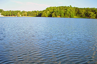
Sylvan Lake is located next to the community by that name in the Town of Beekman, New York, United States. It is the deepest and second-largest lake in Dutchess County.

The Church of St. Charles Borromeo is a Roman Catholic parish church under the authority of the Roman Catholic Archdiocese of New York, located in Dover Plains, Dutchess County, New York. It was founded in 1866 as a mission of Immaculate Conception Parish of Amenia. In 1885 it became a mission of St. John the Evangelist's Church in Pawling, and was finally itself elevated to parish status in 1936.

The Church of St. John the Evangelist is a Roman Catholic parish church under the authority of the Roman Catholic Archdiocese of New York, located in Pawling, Dutchess County, New York.

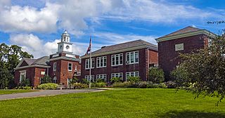
The St. Joseph - Immaculate Conception Catholic Church is a Roman Catholic parish church under the authority of the Roman Catholic Archdiocese of New York, located in Millbrook, Dutchess County, New York.

<span class="mw-page-title-main">Bontecou Lake</span> Body of water

Bontecou Lake, also known as Tamarack Swamp, is a shallow, man-made bifurcation lake in the towns of Stanford and Washington, in Dutchess County, New York, less than 5 mi (8 km) from the Village of Millbrook. Bontecou Lake straddles the drainage divide between the Wappinger Creek watershed to the west and the Tenmile River. Published estimates of its area vary between 113 acres (46 ha) and 135 acres (55 ha), but even the most conservative figures place it among the largest lakes in Dutchess County. Parts of the lake are designated as a Critical Environmental Area, since the area is a crucial habitat for both migrating and breeding waterfowl.

<span class="mw-page-title-main">U.S. Route 44</span> Highway in the United States

U.S. Route 44 (US 44) is an east–west United States Numbered Highway that runs for 237 miles (381 km) through four states in the Northeastern United States. The western terminus is at US 209 and New York State Route 55 (NY 55) in Kerhonkson, New York, a hamlet in the Hudson Valley region. The eastern terminus is at Route 3A in Plymouth, Massachusetts.

References

  1. 1 2 3 4 5 6 7 "Amenia Parks". Amenia, New York Parks Department. 2009. Archived from the original on July 25, 2010. Retrieved December 16, 2009.
  2. 1 2 3 4 Trinka, Mitchell (November 23, 2005). "Lake Amenia, 'New York's vacationland'". Millbrook Round Table. Millbrook, New York: Townnews. Retrieved December 16, 2009.[ permanent dead link ]
  3. "Amenia Station" (PDF). Dutchess County, New York: Harlem Valley Rail Trail. 2009. Archived from the original (PDF) on 26 July 2011. Retrieved 16 December 2009.
  4. Rosendale, Dan (October 2, 2005). "Amenia, N.Y; A 'Laid Back' Place Becomes a Hot Property". The New York Times. New York, New York. Retrieved December 16, 2009.
  5. Amenia Digital Raster Quadrangle (Map). 1:24,000. New York State Department of Transportation. 1989. Retrieved January 20, 2010.
  6. Google (2008-03-24). "overview map of NY 343" (Map). Google Maps . Google. Retrieved 2008-03-24.
  7. "TOWN OF AMENIA Public Hearing and Business Workshop Meeting" (PDF). Amenia, New York: Amenia, New York Town Board. May 14, 2009. Archived from the original (PDF) on July 21, 2011. Retrieved December 16, 2009.