Related Research Articles

Captain George Vancouver was a British Royal Navy officer best known for his 1791–1795 expedition, which explored and charted North America's northwestern Pacific Coast regions, including the coasts of what are now the Canadian province of British Columbia and the U.S. states of Alaska, Washington, Oregon, and California. The expedition also explored the Hawaiian Islands and the southwest coast of Australia.

Saxman is a town on Revillagigedo Island in Ketchikan Gateway Borough in southeastern Alaska, United States. At the 2010 census the population was 411, down from 431 in 2000. The city of Ketchikan lies just to its northwest.
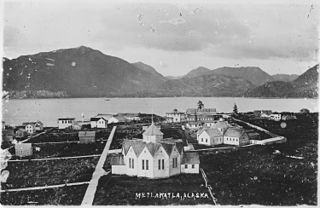
Metlakatla is a census-designated place (CDP) on Annette Island in Prince of Wales-Hyder Census Area, Alaska, United States. At the 2010 census the population was 1,405; this had grown to 1,454 by the 2020 census.
Revillagigedo Channel is an ocean channel in the Alexander Archipelago of the U.S. state of Alaska. Extending 56 km (35 mi) northwest from the Dixon Entrance, it lies between the mainland to the east, Revillagigedo Island to the north, and Duke Island and Annette Island to the southwest. It is part of the Inside Passage to Ketchikan.
Clarence Strait, originally Duke of Clarence Strait, is a strait in southeastern Alaska, in the United States in the Alexander Archipelago. The strait separates Prince of Wales Island, on the west side, from Revillagigedo Island and Annette Island, on the east side. Clarence Strait is 126 miles (203 km) long, extending from Dixon Entrance to Sumner Strait. Moira Sound is on the west side of the strait.
Revillagigedo Island is an island in the Alexander Archipelago in Ketchikan Gateway Borough of the southeastern region of the U.S. state of Alaska. Running about 89 km (50 mi) north-south and 48 km (35 mi) east-west, it is 2,754.835 km² (1,063.65 mi²) in area, making it the 12th largest island in the United States and the 170th largest island in the world. Its center is located near 55°38′03″N131°17′51″W.

Annette Island or Taak'w Aan (Tlingit) is an island in the Gravina Islands of the Alexander Archipelago of the Pacific Ocean on the southeastern coast of the U.S. state of Alaska. It is at 55°08′06″N131°27′21″W. It is about 18 km (11 mi) long and about 18 km (11 mi) wide. The land area is 332.573 km2 (128.407 sq mi). Annette Island is located west across the Revillagigedo Channel from the Alaska mainland and south of Revillagigedo Island. The Island was named in 1879 by William Healey Dall, an American naturalist and explorer in Alaska, in honor of his wife Annette Whitney Dall.

Gravina Island is an island in the Gravina Islands of the Alexander Archipelago in southeastern Alaska. It is 21 miles (34 km) long and about 9.5 miles (15.3 km) wide, with a land area of 94.81 square miles (245.6 km2). The island had a population of 50 people at the 2000 census.
The Gravina Islands are a group of islands that are a part of the Alexander Archipelago in southeast Alaska. The islands are bounded by the Clarence Strait on the west and the Revillagigedo Channel on the east.

Misty Fjords National Monument is a national monument and wilderness area administered by the U.S. Forest Service as part of the Tongass National Forest. Misty Fiords is about 40 miles (64 km) east of Ketchikan, Alaska, along the Inside Passage coast in extreme southeastern Alaska, comprising 2,294,343 acres (928,488 ha) of Tongass National Forest in Alaska's Panhandle. All but 151,832 acres (61,444 ha) are designated as wilderness.

New Eddystone Rock an Alaskan island located in Behm Canal, about 40 miles (64 km) east of Ketchikan. It is a pillar of basalt.
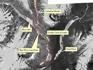
The Unuk River is a river in the U.S. state of Alaska and the Canadian province of British Columbia. It flows from the Coast Mountains southwest to Behm Canal, northeast of Ketchikan, Alaska.
Cape Fox Village is a locality in Southeast Alaska near present-day Ketchikan. It is the site of a former village called Gaash of the Cape Fox people of the Tlingit. The location of the village is on the east side of Revillagigedo Channel, four miles south of Boca de Quadra. The name was recorded in 1880 by Ivan Petroff during the 10th Census, who reported 100 Tlingit still living there. During the Harriman Expedition of Alaska that took place in 1899 several native artifacts that were important to the neighboring populations of Cape Fox were removed and relocated to several academic institutions across the United States, including the Field Museum in Chicago, and Cornell University. The expedition saw the artifacts as inanimate objects from a deserted village. To the Tlingit living nearby, the artifacts were a sacred part of their identity. This event is referred as the "Looting of Cape Fox." Since the looting, several artifacts have been returned to Tlingit communities near Cape Fox in an effort to return stolen artifacts to the ancestors of who created them.
Bell Island is an island in the Alexander Archipelago in Southeast Alaska, United States. It is 14 kilometres (8.7 mi) long, lying in Behm Canal, north of Revillagigedo Island. George Vancouver first visited the island on August 12, 1793, in the evening dining on its south coast. He suspected that it was an island, but this was not proven until later in the same month, when Joseph Whidbey, master of HMS Discovery, charted its entire coastline. Vancouver later named it "Bell's Island" after one of his crew, Midshipman Bell.
Favorite Channel is a channel in Southeast Alaska, northwest of Juneau, Alaska, United States. It is 25 kilometres (16 mi) long, extending northwest from Stephens Passage to Lynn Canal, separating Lincoln and Shelter islands from the mainland to the east. It was named in 1880 by U.S. Navy officers after the 80-foot (24 m) steamboat Favorite, which was chartered by the Navy for surveying work in Alaska, later being used to carry out trading and fishing for the herring plant at Killisnoo. The first European to traverse and chart the channel was Joseph Whidbey, master of HMS Discovery during George Vancouver's 1791–95 expedition, in 1794.

Loring was established in 1885 with the first post office in the District of Alaska and is a census-designated place (CDP) in Ketchikan Gateway Borough in the U.S. state of Alaska. As of the 2020 census, The population is 0, down from 4 at the 2010 census, although the number increases in summer months.

Tongass Narrows is a Y-shaped channel, part of Southeast Alaska's Inside Passage. The waterway forms part of the Alaska Marine Highway and as such, is used by charter, commercial fishing, and recreational vessels, as well as commercial freight barges and tanks, kayaks and passenger ferries. A proposal to build the Gravina Island Bridge across the Tongass Narrows was shelved due to a national-level controversy over the "bridge to nowhere".

Pennock Island is located in the U.S. state of Alaska near the city of Ketchikan. The island is situated within the Ketchikan Gateway Borough and is part of the Alexander Archipelago. Most of the island is public land managed by the Tongass National Forest.
George Inlet is a bay in the U.S. state of Alaska. It is situated within the Alexander Archipelago at the southern shore of Revillagigedo Island. It was named by the United States Coast and Geodetic Survey in 1880 after pilot W. E. George, who created the first sketch of Revillagigedo Channel and Tongass Narrows.

Clover Pass is an unincorporated community in Ketchikan Gateway Borough, Alaska. Workers organized and built the Clover Pass School in 1947 and it was used as a community center in the 1960s. Wards Cove was a shipwreck in the area after an engine fire sank it in 1929. The area, on Clover Passage, includes a marina and is popular for sportfishing as well as kayaking and sailing. It is home to Clover Pass Resort including campsites.
References
- 1 2 U.S. Geological Survey Geographic Names Information System: Behm Canal
- ↑ "Alaska place-names". Archived from the original on 2008-07-08. Retrieved 2008-05-07.
- ↑ Rogoway, Tyler (August 15, 2018). "The U.S. Navy Has A Critically Important Submarine Test Base Tucked Away In Alaska". The War Zone.
| Authority control databases: National |
|---|
55°56′13″N131°11′18″W / 55.93694°N 131.18833°W
| | This article about a location in the Ketchikan Gateway Borough, Alaska is a stub. You can help Wikipedia by expanding it. |