
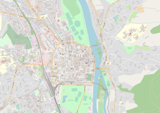
Perth is a centrally located Scottish city, on the banks of the River Tay. It is the administrative centre of Perth and Kinross council area and is the historic county town of Perthshire. It had a population of about 47,430 in 2018.

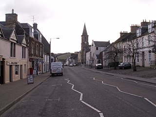
Crieff is a Scottish market town in Perth and Kinross on the A85 road between Perth and Crianlarich, and the A822 between Greenloaning and Aberfeldy. The A822 joins the A823 to Dunfermline. Crieff has become a hub for tourism, famous for whisky and its history of cattle droving. Attractions include the Caithness Glass Visitor Centre and Glenturret Distillery. The nearby Innerpeffray Library is Scotland's oldest lending library. St Mary's Chapel beside it dates from 1508. Both are open to the public: the library is run by a charitable trust; the chapel is in the care of Historic Scotland.

The M90 is a motorway in Scotland. It runs from Junction 1A of the M9 motorway, south of the Queensferry Crossing, to Perth. It is the northernmost motorway in the United Kingdom. The northern point goes to the western suburbs of Perth at Broxden. A small part of the M90 was originally numbered as the M85 motorway.

The Carse of Gowrie is a stretch of low-lying country in the southern part of Gowrie, Perth and Kinross, Scotland. It stretches for about 20 miles along the north shore of the Firth of Tay between Perth and Dundee. The area offers high-quality agricultural land and is well known as a major area for strawberry, raspberry and general fruit growing. Fruit is easy to cultivate in the area because of its southerly aspect and low rainfall. It has been suggested that monks brought new varieties of apples and pears to the area in the Middle Ages and there may have been vineyards growing on slopes near the River Tay.

Auchterarder is a town north of the Ochil Hills in Perth and Kinross, Scotland, and home to the Gleneagles Hotel. The 1+1⁄2-mile-long (2.5-kilometre) High Street of Auchterarder gave the town its popular name of "The Lang Toun" or Long Town.

Pitlochry is a town in the Perth and Kinross council area of Scotland, lying on the River Tummel. It is historically in the county of Perthshire, and has a population of 2,776, according to the 2011 census.

The County of Kinross or Kinross-shire is a historic county and registration county in eastern Scotland, administered as part of Perth and Kinross since 1975. Surrounding its largest settlement and county town of Kinross, the county borders Perthshire to the north and Fife to the east, south and west.

The A92 is a major road that runs through Fife, Dundee, Angus, Aberdeenshire, and Aberdeen City in Scotland. From south to north, it runs from Dunfermline to Blackdog, just north of Aberdeen.
Newburgh is a royal burgh and parish in Fife, Scotland, at the south shore of the Firth of Tay. The town has a population of 2,171, which constitutes a 10% increase since 1901 when the population was counted at 1,904 persons.
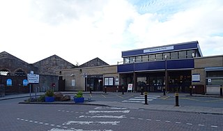
Perth railway station is a railway station located in the city of Perth, Scotland, on both the Glasgow to Dundee line and the Highland Main Line. It is managed by ScotRail, who provide almost all of the services.

Errol is a village in Perth and Kinross, Scotland about halfway between Dundee and Perth. It is one of the principal settlements of the Carse of Gowrie. It lies just north of the River Tay. The 2016 population of Errol was estimated to be 1,500 persons, compared to 1,070 in the 2001 Census.

Dunkeld is a town in Perth and Kinross, Scotland. The location of a historic cathedral, it lies on the north bank of the River Tay, opposite Birnam. Dunkeld lies close to the geological Highland Boundary Fault, and is frequently described as the "Gateway to the Highlands" due to its position on the main road and rail lines north. Dunkeld has a railway station, Dunkeld & Birnam, on the Highland Main Line, and is about 25 kilometres north of Perth on what is now the A9 road. The main road formerly ran through the town, however following modernisation of this road it now passes to the west of Dunkeld.

Bridge of Earn is a small town in Perthshire, Scotland. Often referred to simply as 'The Brig'. The village grew up on the south bank of an important crossing of the River Earn, whose sandstone bridge existed from at least the early 14th century, when it is known to have been repaired by order of King Robert I of Scotland (1306–1329). Substantial remains of the medieval bridge survived into the 1970s, when almost all the stonework was demolished, for (allegedly) being in a dangerously ruinous condition. This ancient bridge was a major landmark on the road between Edinburgh and Perth for several centuries. The village's oldest houses are to be found lining the road leading south from the site of the demolished bridge. Among them are some with 18th-century datestones.
There have been several railway stations serving the town of Newburgh, Fife. The original was opened on 17 May 1848 by the Edinburgh and Northern Railway, on their line from Ladybank to Hilton Junction, near Perth. This station lasted until August 1906, when a larger replacement station was opened.
The A912 is a major road in both Perth and Kinross and Fife, Scotland. It runs from the A9 in Perth, in the north, to the A92 at Muirhead, in the south. Part of it was formerly part of the A90.
Longforgan is a village and parish in the Carse of Gowrie, in Perth and Kinross, Scotland. It lies 5 miles west of Dundee on the main A90 road.

Glenfarg is a village in the Ochil Hills in Perth and Kinross, Scotland. Until 14 June 1964, the village had a railway station, Glenfarg railway station, on the main line between Perth and Edinburgh via Kinross. Although not recommended for closure under the Beeching Axe, the line nevertheless closed to passengers and freight on 5 January 1970, resulting in slower passenger services to Perth via longer routes. The former railway line is now the route of the M90 motorway, which runs along the eastern periphery of the village. At its peak, the village became a popular holiday destination, boasting 4 hotels. Services in the village include a church, small shop, tennis courts, riding school and a primary school with nursery.
The Railways of Kinross were a local network of three rural railways which made the town of Kinross in Scotland their objective in the 1850s.

South Inch is a large public park in Perth, Scotland. About 31 hectares in size, it is one of two "Inches" in Perth, the other being the larger, 57-hectare North Inch, located half a mile across the city. The Inches were granted to the city, when it was a royal burgh, by King Robert II in 1374. Both Inches were once islands in the River Tay. The two Inches are connected by Tay Street.
The A989 is a road in Perth, Scotland. Also known as the Perth Inner Ring Road, due to its circumnavigation of the city centre, it is 1.93 miles (3.11 km) long. Perth's city centre is around 0.5 miles (0.80 km) long and wide. The road was constructed around 1985.


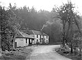 The inn in 1905, looking west along the B996. The building closest to the camera, at the corner of the old Great North Road, is no longer part of the inn