
Transport in Pakistan is extensive and varied. In recent years, new national highways have been built, with the addition of motorways which have improved trade and logistics within the country. Pakistan's rail network is also undergoing expansion in recent years. Airports and seaports have been built with the addition of foreign and domestic funding. Transportation challenges in Pakistan are escalating due to poor planning, inadequate governance, and corrupt practices.

The Eurasian Land Bridge, sometimes called the New Silk Road, is the rail transport route for moving freight and passengers overland between Pacific seaports in the Russian Far East and China and seaports in Europe. The route, a transcontinental railroad and rail land bridge, currently comprises the Trans-Siberian Railway, which runs through Russia and is sometimes called the Northern East-West Corridor, and the New Eurasian Land Bridge or Second Eurasian Continental Bridge, running through China and Kazakhstan. As of November 2007, about one percent of the $600 billion in goods shipped from Asia to Europe each year were delivered by inland transport routes.
Rail transport in Australia is a component of the Australian transport system. It is to a large extent state-based, as each state largely has its own operations, with the interstate network being developed ever since Australia's federation in 1901. As of 2022, the Australian rail network consists of a total of 32,929 kilometres (20,461 mi) of track built to three major track gauges: 18,007 kilometres (11,189 mi) of standard gauge, 2,685 kilometres (1,668 mi) of broad gauge, and 11,914 kilometres (7,403 mi) of narrow gauge lines. Additionally, about 1,400 kilometres (870 mi) of 610 mm / 2 ft gauge lines support the sugar-cane industry. 3,488 kilometres (2,167 mi), around 11 percent of the Australian heavy railways network route-kilometres are electrified.
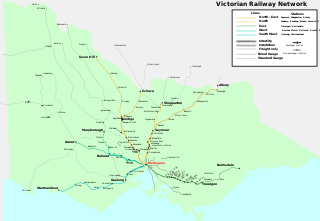
Rail transport in the Australian state of Victoria is provided by a number of railway operators who operate over the government-owned railway lines. The network consists of 2,357 km of Victorian broad gauge lines, and 1,912 km of standard gauge freight and interstate lines; the latter increasing with gauge conversion of the former. Historically, a few experimental 762 mm gauge lines were built, along with various private logging, mining and industrial railways. The rail network radiates from the state capital, Melbourne, with main interstate links to Sydney and to Adelaide, as well as major lines running to regional centres, upgraded as part of the Regional Fast Rail project.
Australians generally assumed in the 1850s that railways would be built by the private sector. Private companies built railways in the then colonies of Victoria, opened in 1854, and New South Wales, where the company was taken over by the government before completion in 1855, due to bankruptcy. South Australia's railways were government owned from the beginning, including a horse-drawn line opened in 1854 and a steam-powered line opened in 1856. In Victoria, the private railways were soon found not to be financially viable, and existing rail networks and their expansion were taken over by the colony. Government ownership also enabled railways to be built to promote development, even if not apparently viable in strictly financial terms. The railway systems spread from the colonial capitals, except for a few lines that hauled commodities to a rural port.
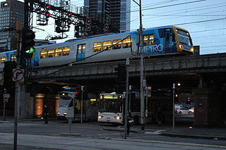
Transport in Melbourne, the state capital of Victoria, Australia, consists of several interlinking modes. Melbourne is a hub for intercity, intracity and regional travel. Road-based transport accounts for most trips across many parts of the city, facilitated by Australia's largest freeway network. Public transport, including the world's largest tram network, trains and buses, also forms a key part of the transport system. Other dominant modes include walking, cycling and commercial-passenger vehicle services such as taxis.
South Road and its southern section as Main South Road outside of Adelaide is a major north–south conduit connecting Adelaide and the Fleurieu Peninsula, in South Australia. It is one of Adelaide's most important arterial and bypass roads. As South Road, it is designated part of route A2 within suburban Adelaide. As Main South Road, it is designated part of routes A13 and B23.

The Islamic Republic of Iran Railways is the national state-owned railway system of Iran. The Raja Passenger Train Company is an associate of the IR, and manages its passenger trains. The Railway Transportation Company is an associate of the IR, which manages its freight transport. The Ministry of Roads & Urban Development is the state agency that oversees the IRIR. Some 33 million tonnes of goods and 29 million passengers are transported annually by the rail transportation network, accounting for 9 percent and 11 percent of all transportation in Iran, respectively (2011).

Transnet Freight Rail is a South African rail transport company, formerly known as Spoornet. It was part of the South African Railways and Harbours Administration, a state-controlled organisation that employed hundreds of thousands of people for decades from the first half of the 20th century and was widely referred to by the initials SAR&H. Customer complaints about serious problems with Transnet Freight Rail's service were reported in 2010. Its head office is in Inyanda House in Parktown, Johannesburg.
AusLink is a former Government of Australia land transport funding program, that operated between June 2004 and 2009. The former program was administered by the former Department of Transport and Regional Services. In 2009, the program was replaced with the Nation Building Program under the Nation Building Program Act 2009. The Nation Building Program was administered by the Department of Infrastructure and Transport and that program was replaced by The National Land Transport Network, as determined by the Minister for Infrastructure and Regional Development under the National Land Transport Act 2014.

The Onehunga Branch railway line is a section of the Onehunga Line in Auckland, New Zealand. It was constructed by the Auckland Provincial Government and opened from Penrose to Onehunga on 24 December 1873, and extended to Onehunga Wharf on 28 November 1878. It is 3.6 kilometres (2.2 mi) in length and is single-track only.

The Sydney Freight Network is a network of dedicated railway lines for freight in Sydney, Australia, linking the state's rural and interstate rail network with the city's main yard at Enfield and Port Botany. Its primary components are the Southern Sydney Freight Line (SSFL) and a line from Sefton to Enfield and Port Botany. The Network has been managed by the Australian Rail Track Corporation (ARTC) since 2012. Prior to the completion of the SSFL, it was managed by RailCorp as the Metropolitan Freight Network.

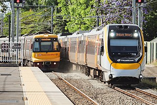
The rail network in Queensland, Australia, was the first in the world to adopt 1,067 mm narrow gauge for a main line, and, in 2013, was claimed to the second largest narrow gauge network in the world, consists of:

Rail transport in Tasmania consists of a network of narrow gauge track of 1,067 mm reaching virtually all cities and major towns in the island state of Tasmania, Australia. Today, rail services are focused primarily on bulk freight, with no commercial passenger services being operated. The mainline railways of Tasmania are currently operated by TasRail, a Government of Tasmania-owned Corporation, who owns and maintains both rolling stock, locomotives, and track infrastructure.
The Mildura railway line is a heavy rail line in northwestern Victoria, Australia. The line runs from Yelta station to Ballarat station via the settlements of Mildura, Ouyen and Maryborough in an approximate south-southeasterly direction. Initial sections of the line opened from Ballarat in 1874 and the line reached Mildura in 1903.

The rail network of Melbourne, Australia, has a significant number of railway lines and yards serving freight traffic. Rail transport in Victoria is heavily focused on Melbourne, and, as a consequence, much of the state's rail freight passes through the metropolitan network.
The city of Hobart, Tasmania is served by a wide variety of transport. While the city's main form of transport is private transport on the road network, transport is also available by bus, ferry and aircraft. A suburban train service operated between Hobart and Brighton from the 1870s until 31 December 1974. There has been, however, talk in recent years of reinstating a train service in the northern suburbs.
Bell Bay is an industrial centre and port located on the eastern shore of the Tamar River, in northern Tasmania, Australia. It lies just south of George Town. In the year ended June 2021, 3.6 million tonnes of exports and imports passed through Bell Bay.

The Redcliffe Peninsula line is a 12 km (7.5 mi) stretch of heavy gauge dual-track railway between Petrie and Kippa-Ring on the Redcliffe peninsula in Queensland, Australia. The new line is part of Queensland Rail's City suburban network, branching from the North Coast line. It starts 200 metres (656 ft) north of Petrie railway station, extending from.

The South Line, also known as the Main Line and sometimes the North/South Line or the North–South Line, is a rail corridor connecting Hobart to the northern ports of Tasmania. The Railway Line was built by the Tasmanian Main Line Company.